Second day of blizzard conditions prompt school, road closures on the Prairies

A fast-moving Alberta clipper threatens dangerous travel across parts of the Prairies through Tuesday morning, followed by a blast of Arctic air that will bring frigid temperatures back Wednesday.
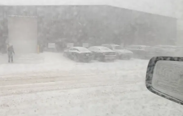
The end of January went out on a stormy note on the Prairies, as a quick-moving clipper brought blizzard conditions across a large swath of the region Monday. While conditions have improved in Alberta, blowing snow and blizzard conditions will persist into Tuesday for parts of Saskatchewan and Manitoba, with some areas still on the hook for 15-20 cm of additional snowfall before the system departs. In behind it will be another shot of bitter Arctic air, set to send daytime highs plummeting into the -20s or colder, with wind chills into the -30s for some. More on what's left of the clipper, still-to-come impacts and the cold temperatures beyond, below.
RELATED: See it here: Blizzard-like conditions move through the Prairies
TUESDAY: BLIZZARD CONDITIONS LINGER IN EASTERN PRAIRIES
As the clipper system continues marching east, widespread blizzard and snowfall warnings cover Manitoba Tuesday morning, prompting several road and school closures first thing. Extreme cold warnings were also issued for northern sections of the province.
The falling snow and strong winds gusting between 70-90 km/h will reduce visibilities to near-zero at times, with drivers being urged to avoid any non-essential travel.
"Travel is expected to be hazardous due to reduced visibility. Visibility will be suddenly reduced to near zero at times in heavy snow and blowing snow. Prepare for quickly changing and deteriorating travel conditions," says Environment and Climate Change Canada in the blizzard warning.
Several flights at Winnipeg Richardson International Airport were also delayed or cancelled because of the poor conditions Tuesday morning.

Snow and winds are expected to subside across both Saskatchewan and Manitoba by the afternoon, as winds die down from west to east.
Additional snowfall accumulations will be the heaviest in central Manitoba, in the Interlake Region, where 15-20 cm is still to come through Tuesday. Parts of central Saskatchewan could see aother 5-10 cm before the clipper moves out completely.
BLOWING SNOW CREATES SCARY DRIVING CONDITIONS ON ALBERTA HIGHWAYS MONDAY
EXTREME COLD RETURNS
Behind this system, brisk Arctic air flows in with bitter wind chill values reaching into the -20s and -30s. For Alberta, it will be a short-lived chill for southern areas as temperatures climb to the freezing mark by Thursday.
Daytime highs in the mid -20s are possible, with lows approaching -40°C and the wind chill extending into the -40s.

Saskatchewan and Manitoba will continue to see frigid temperatures this week as relief sets in for the weekend with temperatures hovering above seasonal.
Meanwhile, another clipper is expected to develop over northern Alberta Thursday night and Friday, and then dive southeast to near southern Manitoba on Saturday. It will bring a swath of snow primarily near and north of the Yellowhead Highway.
Thumbnail image courtesy of Brycen Mitchell/Saskatoon, Sask.
Check back for the latest updates on conditions across the Prairies.