Up to 400 mm: B.C. faces flooding, avalanche risks from atmospheric river
An unseasonable atmospheric river event is set to impact British Columbia. It will bring torrential rainfall, rising freezing levels and rapid snowmelt, leading to a significant risk of flooding and avalanches
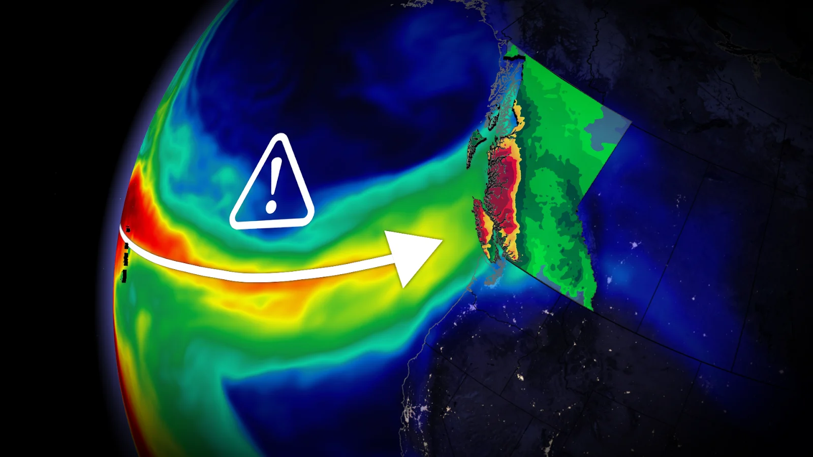
A strong-rated atmospheric river is expected to bring significant, prolonged rainfall to British Columbia through this week.
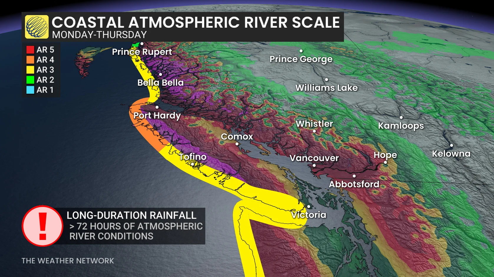
Expected to rank as an AR3 or AR4 event along the immediate coastline, the result to B.C. is a heightened avalanche danger and a rising flood threat. It's unusual to have such a potent atmospheric river for mid-March. Most of the affairs tend to happen in mid-fall and early winter.
RELATED: What’s a Pineapple Express? Diving into this robust atmospheric river
Some areas could see 75 mm to 400 mm of rain while other locales could see up to 100 consecutive hours of rain without a break.
Expect extensive water pooling on roads and washouts may occur, so there could be road closures and difficult travel with the rainfall.
Pineapple express expected through much of this week
A pineapple express is an atmospheric river that originates near Hawaii. This deep, rich plume of tropical moisture can fuel heavy rainfall and rising freezing levels across southwestern B.C.

There has been lots of lower-elevation snow in elevations 400-1200 metres over the past week, increasing run-off with snowmelt.
Given its strength and predicted longevity, forecasters anticipate this upcoming pineapple express event to rank an AR3 or AR4 along the immediate coastline, which means this type of event is often hazardous with river flooding impacts possible. Some areas could see the atmospheric river endure in two waves and persist for more than 72 hours.

Some remote locations on western Vancouver Island and the North Shore Mountains will be subjected to up to 100 straight hours of rainfall this week. That’s more than four days of consecutive rainfall, highlighting the risk of flooding and rapid snowmelt.
Sunday afternoon initially features low snow levels on Vancouver Island and the Lower Mainland, with wet snow above 300 metres in elevation.
This surge of moisture tracking northeast directly from Hawaii will fuel heavy rainfall beginning late Sunday and continuing into next work week.
DON’T MISS: A potentially strong El Niño will develop by this summer

Rainfall forecast
Tofino: 200-400 mm
North Shore Mountains: 150 mm-200+ mm
Squamish: 150 mm-200 mm
Campbell River/Comox Valley: 75 mm
Nanaimo: 50-75 mm
Victoria: Approximately 50 mm
Lower Mainland (south of Fraser River: 75 mm-100 mm)
North of Fraser: 100-200 mm

In addition to the heavy rainfall, we’ll also see freezing levels spike to more than 2000 metres on Monday, a rise that will last through the week before falling on Friday.
As a result, alpine rain is expected over the course of the week, leading to the elevated avalanche danger .

Monday's avalanche danger is serious at high levels for Vancouver Island, the Sea-to-Sky, South Coast inland, and the northern and southern Columbia Mountains.
Significant snow that fell through the beginning of the month will begin to melt next week with the arrival of warmer temperatures.
The combination of heavy rainfall and snowmelt will likely elevate flood alerts throughout the region during the days ahead.
Pay close attention to forecasts and alerts for your area in the coming days.
Stay with The Weather Network for all the latest on conditions across B.C.