Potentially damaging fall storm threatens Ontario on the weekend

As Ontario snaps back into a more typical November reality, a classic fall storm that may have damaging impacts is on deck for the weekend.
Temperatures have been falling to more seasonal levels into the weekend, continuing Saturday, albeit with a touch of sun during the day. Sunday will be a different story, however, with an incoming fall storm set to bring cold showers and strong, potentially damaging winds, followed by some lake-effect snow for some. Winds up to 100+ km/h, possible shoreline flooding and a swath of heavy snow for northern areas are all in play for Sunday. More on the timing and areas impacted, below.
WEATHER HIGHLIGHTS:
Temperatures tumble back to seasonal values across Ontario Saturday
Eyes on a potentially damaging fall storm Sunday that will bring rain, powerful winds to southern Ontario, risk of shoreline flooding
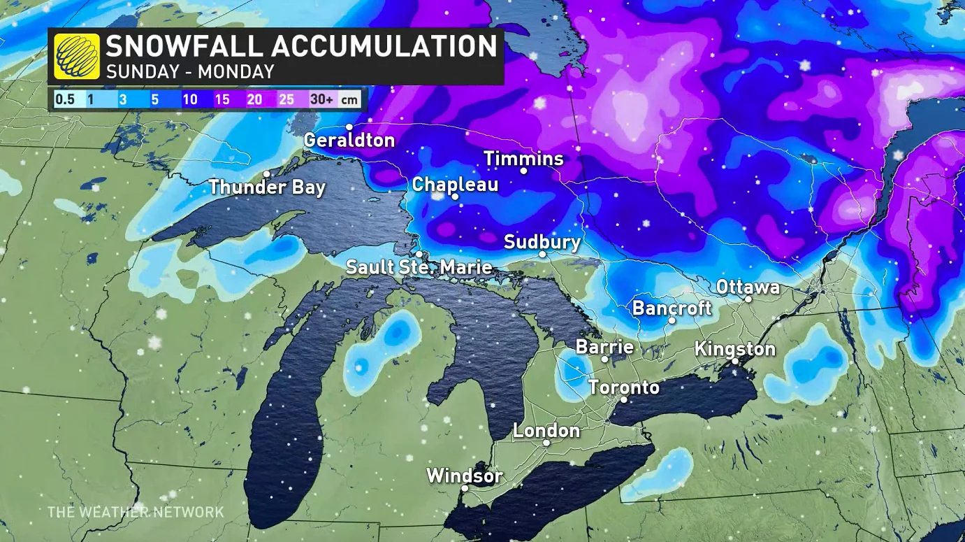
Heavy snow expected north and east of Lake Superior with 10-15+ cm forecast through Monday
SATURDAY: TEMPERATURES DROP, SUNSHINE TO START THE WEEKEND
The start to the weekend will noticeably chillier than on Friday, with daytime highs likely to stay below the 10°C mark, especially in cottage country and eastern areas, where they will hover closer to freezing.
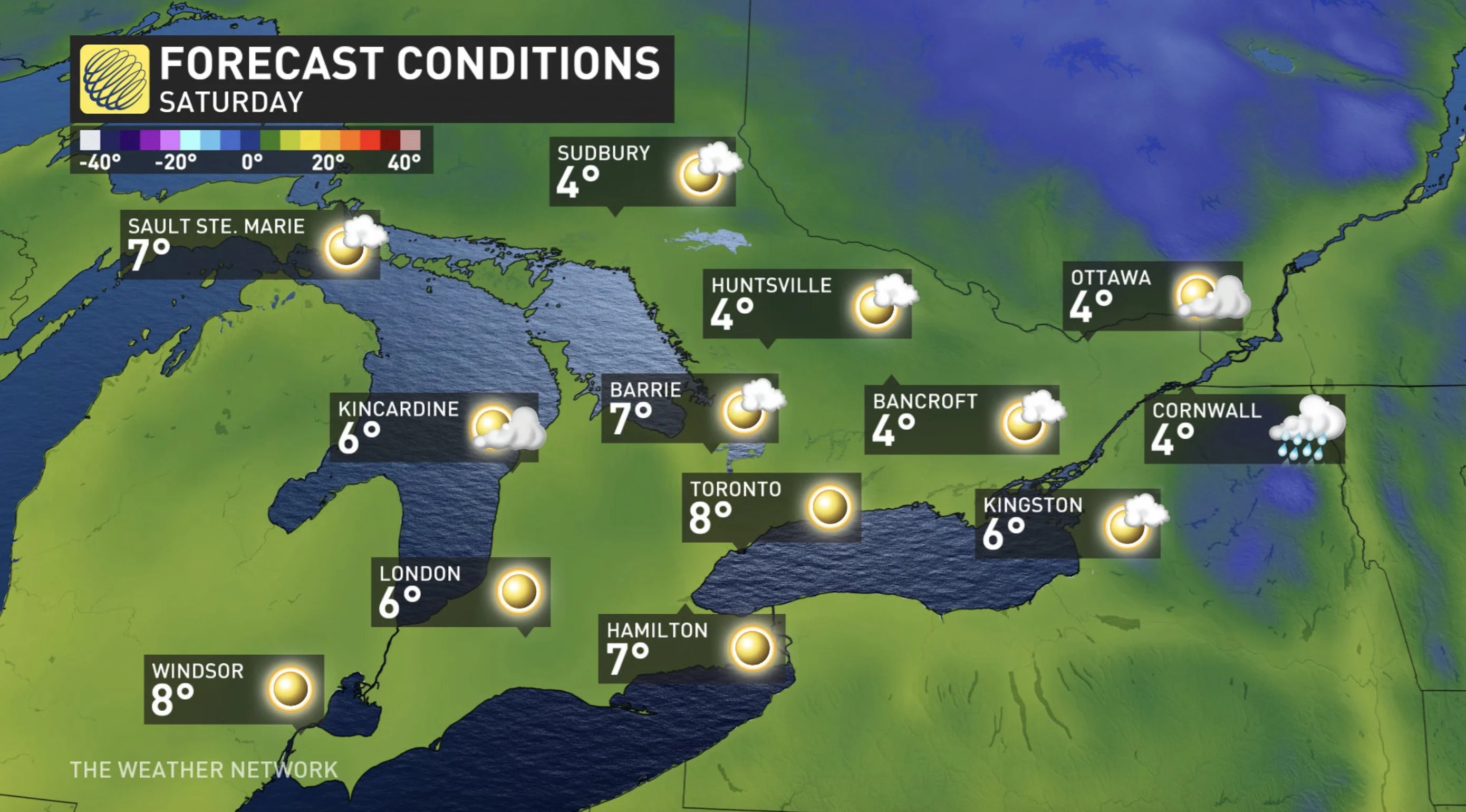
The upside is that most of the day will be dry, but rain from an impending potent low will begin to push into the southwest in the evening hours, spreading east into southern areas overnight. Winds will also pick up during this time, with gusts of 40-60 km/h along the lakeshores.
SUNDAY INTO MONDAY: COLORADO LOW THREATENS STRONG WINDS AND RAIN
By early Sunday morning, the effects from that Colorado low will be entrenched across the Great Lakes region and northern Ontario. This storm will bring strong, potentially damaging winds and rain to southern Ontario and heavy snow in the north.
MUST SEE: November still tips to the milder side despite some wintry interruptions
Strong, potentially damaging, winds are likely, with gusts of 80-100 km/h across the south -- possibly reaching 110 km/h near lakes Erie, eastern shores of Huron and eastern Georgian Bay -- in the afternoon and evening hours on the backside of the low.
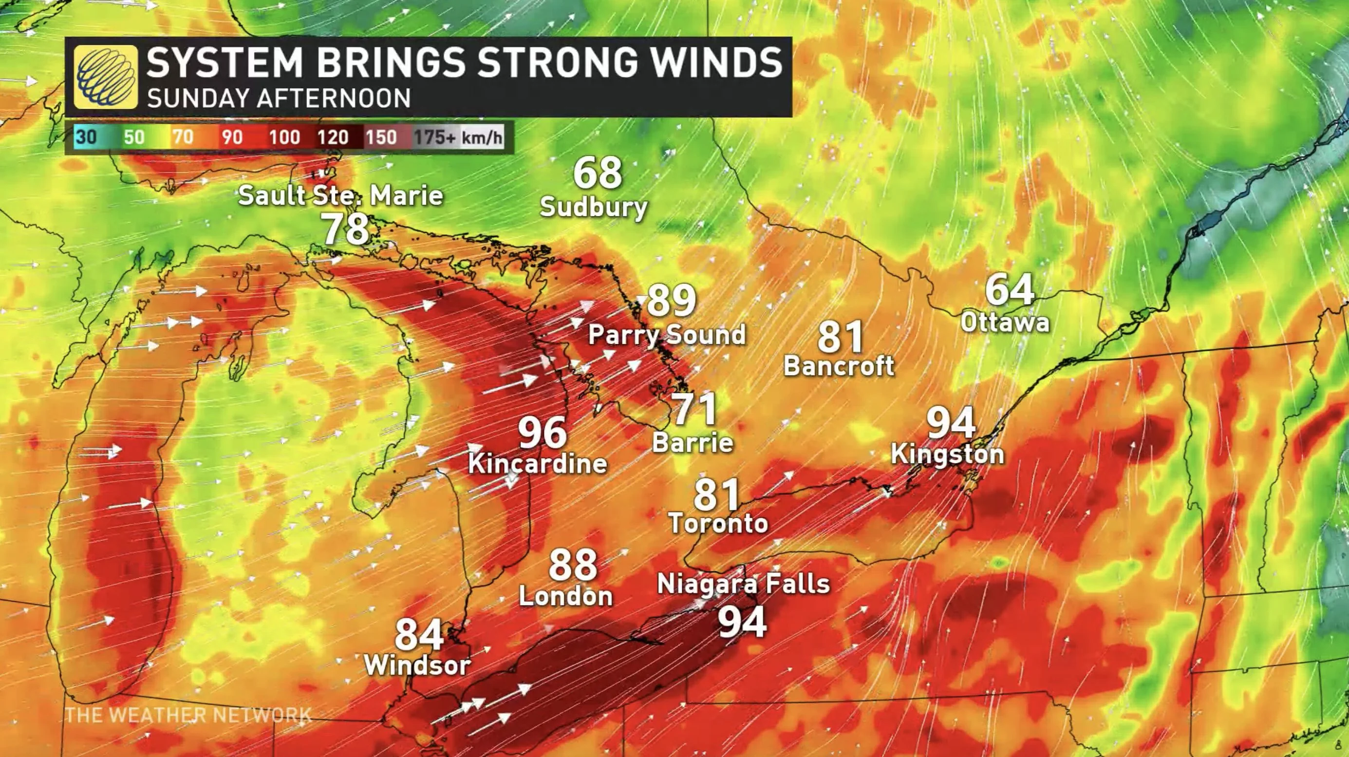
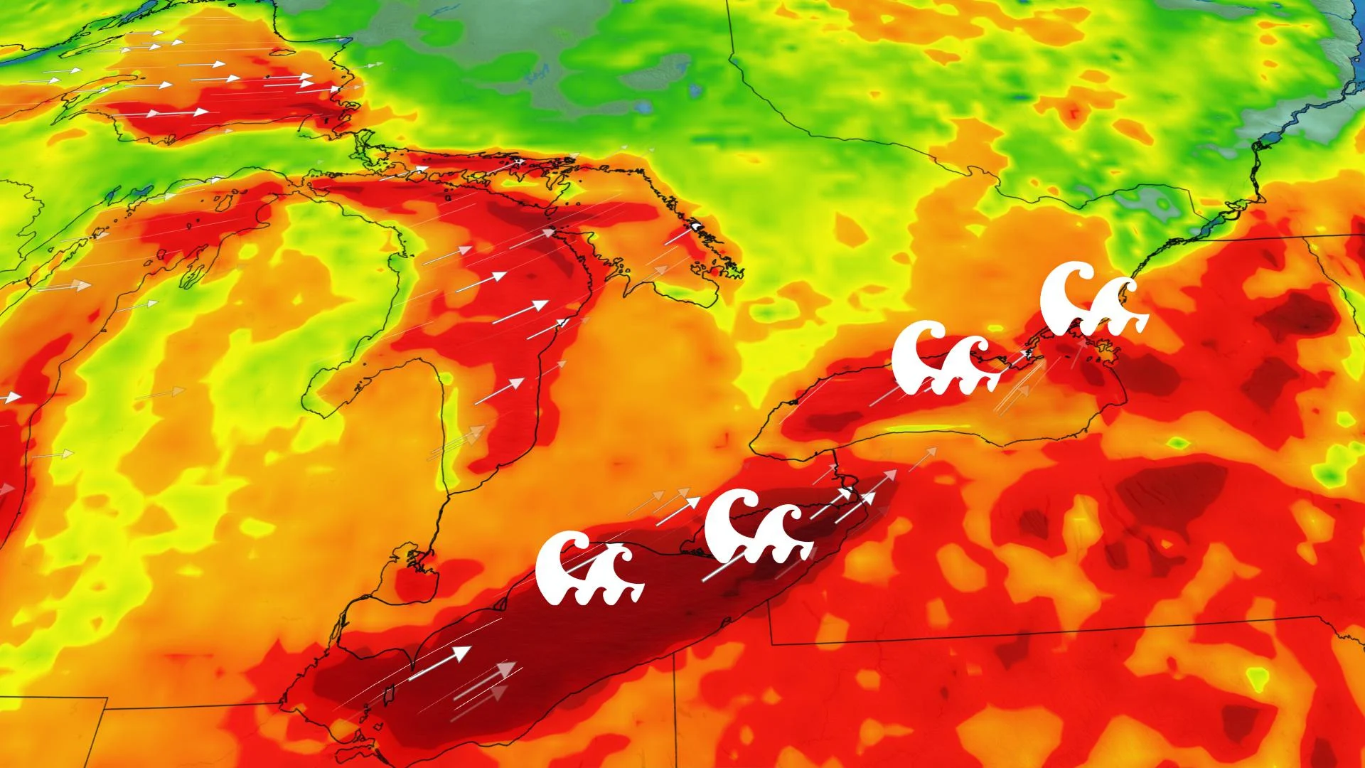
These winds will heighten the risk for shoreline flooding due to the current high lake levels and large waves.
“Our greatest concern is for the north shore of Lake Erie, from Long Point to Fort Erie, as a seiche is expected with significant lakeshore flooding. Wind gusts could reach 120 km/h along the north shore of Lake Erie,” says Weather Network meteorologist Dr. Doug Gillham.
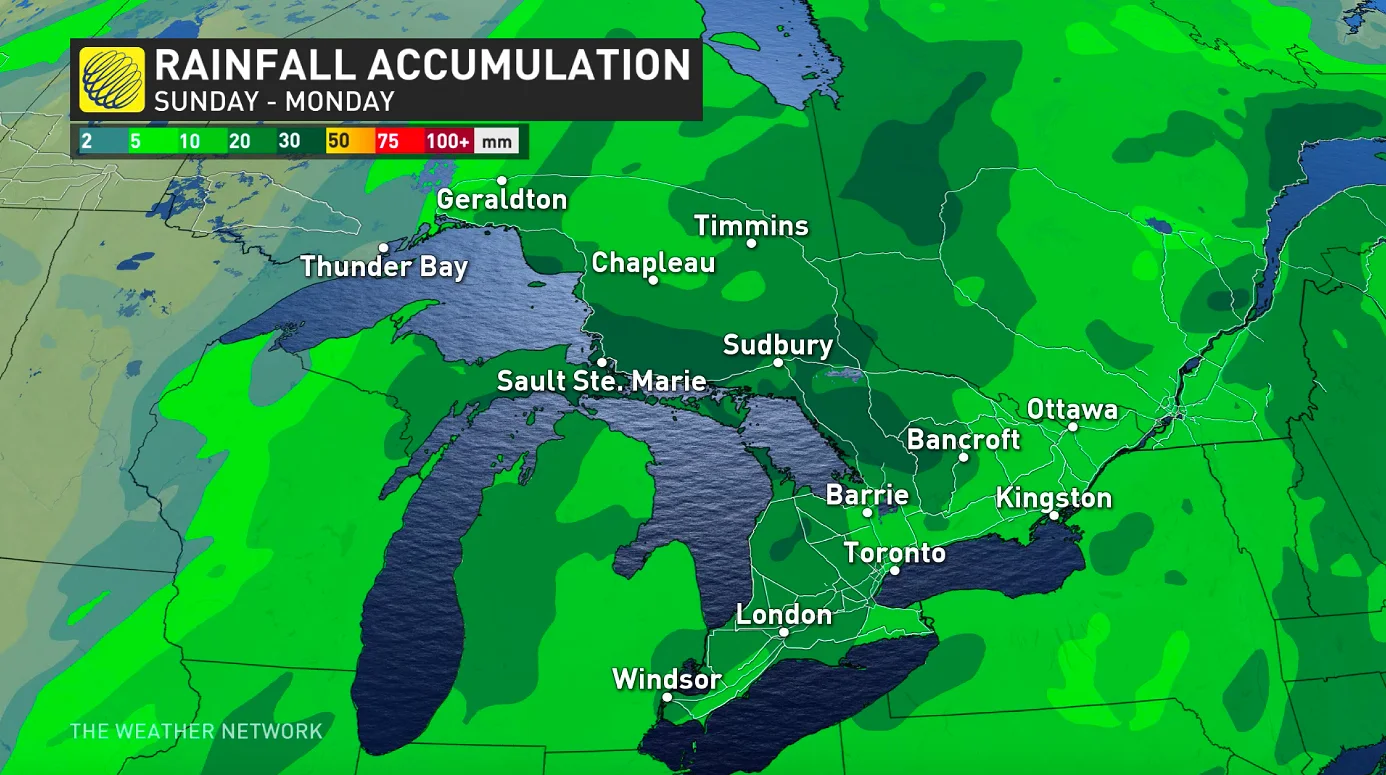
As for the snow from this system, the most significant amounts will fall across parts of northern Ontario with this system, with 10-15+ cm forecast for areas north and east of Lake Superior. The snow will change to rain across much of northeastern Ontario.
INTO NEXT WEEK: SNOW CONTINUES FOR SOME AREAS
For the south of the province, the icy winds of the still unfrozen Lake Huron and Georgian Bay will set up lake-effect snow squalls, beginning Sunday night and continuing on and off into Wednesday.
The first round of flurries and squalls will initiate east of Georgian Bay and Lake Huron. Substantial snow totals are possible, especially east of Georgian Bay.
The bands could briefly weaken or even fall apart Monday before a colder blast of Arctic air arrives Monday night and Tuesday, which will reignite the squall, this time southeast of Georgian Bay and Lake Huron.
"Heavy snow and difficult travel are likely across the snow belts. Flurries and quick bursts of heavier snow will extend into parts of the GTA. Wednesday will be the coldest day with temperatures remaining well below freezing north of the GTA and across southern Quebec," adds Gillham.
TEMPERATURES RECOVER LATE NEXT WEEK
Milder weather will return for late week and on the weekend with temperatures recovering to near or above seasonal. However, forecasters are keeping an eye on the warm front and possibly a system with the transition to milder weather around Thursday.
"The cold air could resist and bring a period of messy/wintry weather, especially for areas well north of the GTA, eastern Ontario and southern Quebec," Gillham says.
Be sure to check back as we continue to fine tune the details of this weekend storm.
Subscribe: Apple Podcasts | Amazon Alexa | Google Assistant | Spotify | Google Podcasts | iHeartRadio | Overcast