Spring sits on the sidelines with winter’s wild ride to the finish line

Most Canadians will need to be patient as winter lingers on and we wait for warmer spring weather. Expect a sluggish start to the season in most areas.
Spring-like weather arrived early this year across most of Canada, with extended thaws and even record-breaking warmth at times during the heart of winter. Was spring just teasing us, or can we anticipate that consistent warm weather will arrive early this year?
According to The Weather Network’s 2023 Spring Forecast for the months of March, April and May, most Canadians will need to be patient as we wait for consistent warm weather.
While winter lacked commitment this year with episodes of severe winter weather followed by extended periods of early spring-like weather, it appears that winter will attempt to make up for lost time during March and even into April. Several more rounds of wintry weather are expected across the country before spring finally hits its stride.
The sluggish start to spring should result in most of Canada seeing temperatures that are near normal or on the cool side of normal for the season. Here is a look at our national forecast map for March, April, and May:
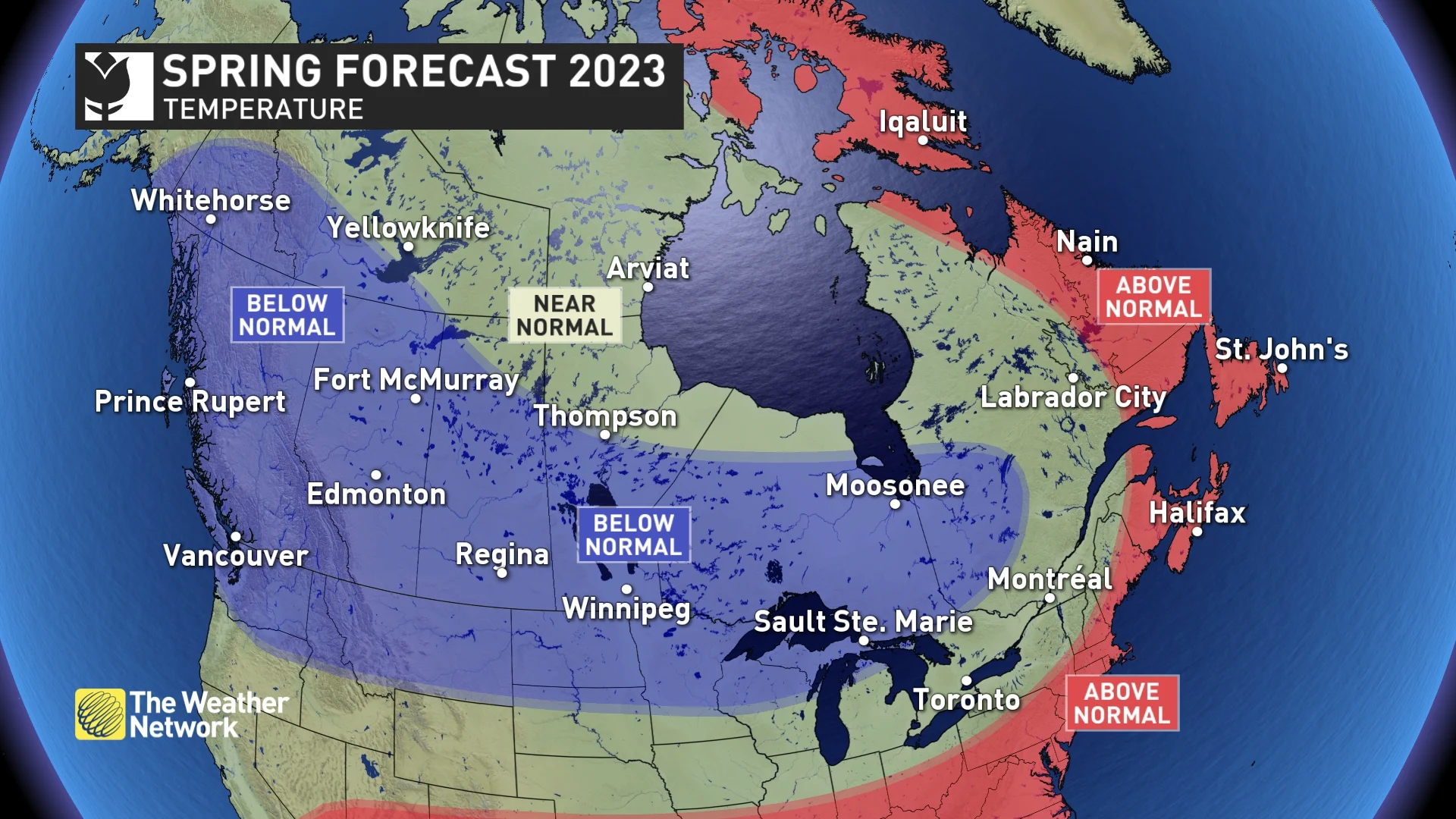
Even the regions where we expect near-normal and warmer-than-normal temperatures can expect an extended period of colder-than-normal temperatures during March and into April.
RELATED: We have TWO first days of spring, but which one is real?
Spring Pattern Drivers: Goodbye La Niña; Hello El Niño?
The primary driver of the spring weather pattern is the fading La Niña pattern in the Pacific Ocean. La Niña is associated with cooler than normal ocean water temperatures near the Equator and to the west of South America. This has a strong influence on the jet stream pattern across the Northern Hemisphere.
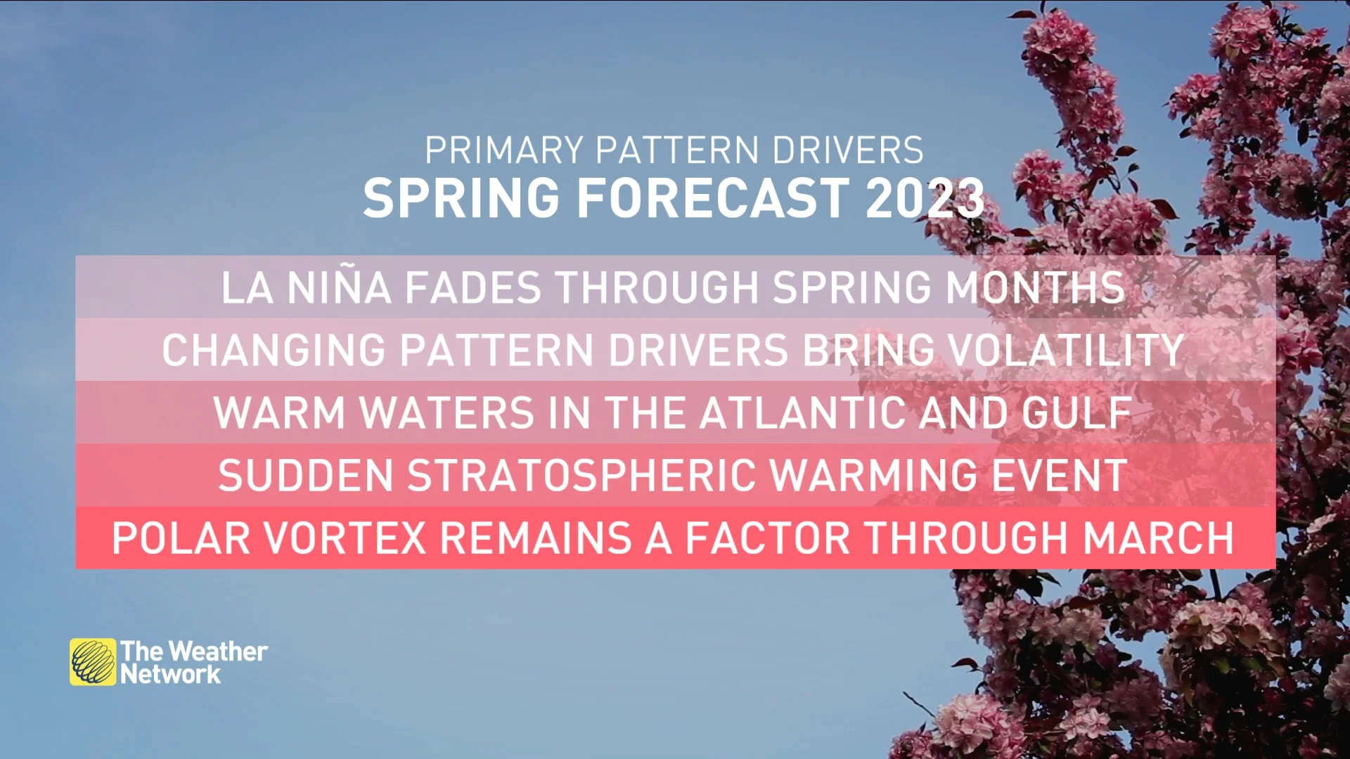
La Niña has been with us for the past three years, but this pattern is quickly fading now, and it appears that we could head into an El Niño pattern later this year. A fading La Niña pattern is often associated with a sluggish spring, especially across western Canada.
DON'T MISS: La Niña fades, so what does that mean for a Canadian spring?
In addition, a strong blocking pattern is developing over the Arctic, and the polar vortex is expected to be more displaced than normal during the first half of the season. This combination should deliver colder than normal temperatures at times during March and into April.
Spring is typically an active weather season as the atmosphere is in a state of change as we make the transition from winter to summer. Add to that a reversal in the primary pattern driver (especially one that has been with us for three years), and that is a recipe for active and stormy weather.
Therefore, we expect that most of Canada will see near-normal or above-normal precipitation for the season.
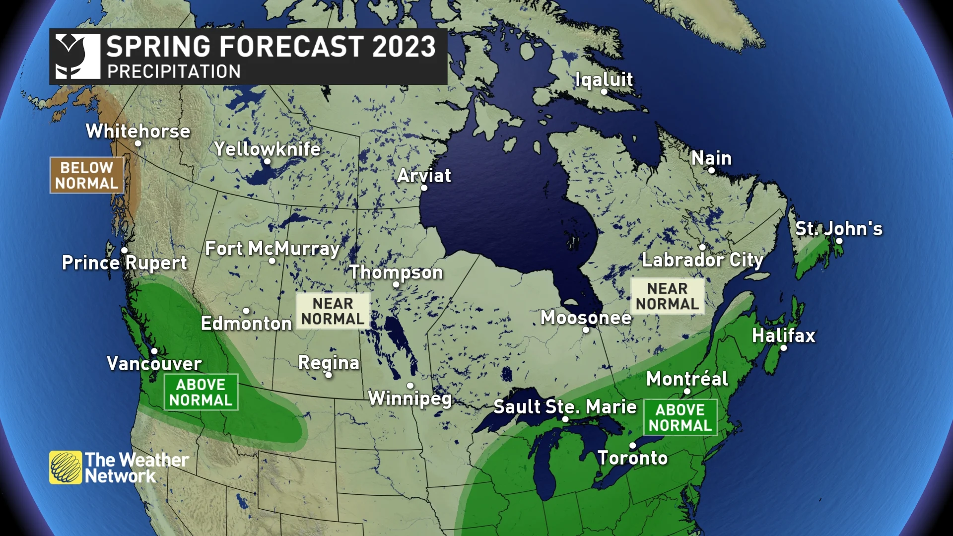
However, while it is inevitable that there will be parts of the country that are often missed by the spring storms and end up dry, the long-range signals are not strong enough to specifically identify those areas just yet. The Prairies are one area that we will be watching closely, especially since parts of the region are experiencing a multi-year drought. Receiving adequate spring precipitation across this region will be critical to a successful agricultural season.
MUST SEE: Canada was a global climate hot-spot in January
Below is a more detailed look at the regional conditions expected during March, April, and May:
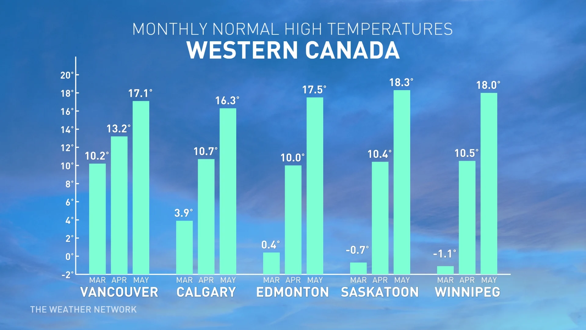
British Columbia
While the South Coast region of B.C., including Vancouver and Victoria, is typically the first region in Canada to see the arrival of consistent spring weather, a slower than normal start to the season is expected with below-normal temperatures, especially during March and April.
Cooler weather and slightly above-normal precipitation, including heavy snow in the alpine regions, should allow for an extended spring ski season. These conditions should also reduce the risk of an early start to the fire season and help replenish reservoirs before we head into summer.
WATCH: Your love of spring will depend on your love of snow
Alberta
A slow start to spring is expected with colder than normal temperatures, especially during the first half of the season. Therefore, March and even April could look and feel more wintry than what we experienced at times during the heart of winter. Near-normal precipitation is expected across most of the region, but southwestern Alberta has the potential to see above-normal precipitation totals.
Much of the province will start the spring in better condition in terms of soil moisture compared to this time last year. However, it is still critical for agriculture that the central and southern parts of the province receive adequate precipitation during the next three months to replenish the groundwater following the multi-year drought.
WATCH: Winter looks to 'strike back' on the Prairies
Saskatchewan and Manitoba
Spring is expected to start more slowly than normal across Manitoba and Saskatchewan, with colder than normal temperatures, especially during the first half of the season. As a result, March and April could look and feel more like winter than what we experienced at times during the heart of winter. Near normal precipitation is expected across most of the region.
At this point, spring flooding is not a major concern across southern parts of the region, as most areas received near-normal or below-normal snowfall during the winter, and the outlook for spring is for much drier conditions than last year, especially across southern Manitoba. Further to the north, the spring flood risk is near normal and locally above normal.
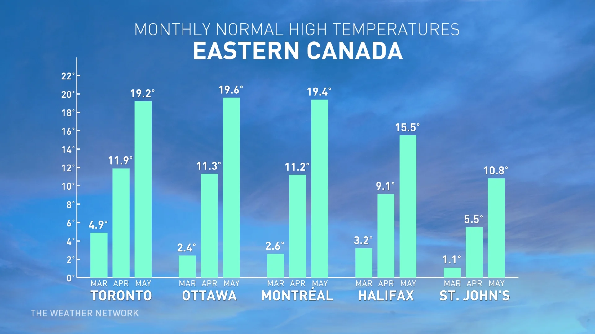
Ontario
Extended periods of early spring-like weather during the heart of winter provided false hope that spring was going to arrive early this year. March and even parts of April will feature several bouts of late winter weather, with periods of colder than normal temperatures and messy winter storms at times. However, we are watching the potential for a strong ending to the season with warmer and drier weather.
MUST SEE: Rideau Canal Skateway won't open this winter
An active storm track is expected across southern Ontario through at least April, as this region will be the battleground between colder weather to the north and a much milder pattern over the eastern U.S., which will attempt to surge north at times. This will bring above-normal precipitation to southern Ontario and parts of northern Ontario for the season.
The risk for spring flooding appears to be lower than normal, especially across southern Ontario, as the extended winter thaw greatly reduced the snowpack and the amount of ice on creeks and rivers. The snowpack across northern Ontario is more substantial, but in most places it is much less than this time last year. However, a snowy March could increase the spring flood risk later in the season.
WATCH: What does a fading La Niña mean for spring in Ontario?
Quebec
Through most of the winter, temperatures were well above seasonal, with just brief periods of severe cold. However, that does not mean that spring will arrive early this year. March and even parts of April will feature several bouts of winter weather, with periods of colder than normal temperatures and messy winter storms at times. However, we are watching the potential for a warmer and drier ending to the spring season.
An active storm track is expected across southern Quebec through at least April, as this region will be the battleground between colder weather to the north and a much milder pattern over the eastern U.S., which will attempt to surge north at times. This should bring above-normal precipitation to southern Quebec.
RELATED: Spring is here: When should you take your winter tires off?
The risk for spring flooding currently appears to be lower than normal as the extended winter thaw greatly reduced the snowpack. However, a snowy March could elevate the spring flood risk for later in the season.
WATCH: Will the word of the season be 'extremes' for Quebec?
New Brunswick, P.E.I. and Nova Scotia
While mild weather dominated through most of the winter, a colder pattern will take shape in March and April, along with a more active storm track, bringing a strong end to a lacklustre winter season. This pattern change includes a heightened risk for late-season winter storms.
That being said, spring should make a solid recovery during the second half of the season, with temperatures ending up near seasonal levels or warmer than seasonal across the region.
Frequent thaws throughout the winter have prevented a deep snowpack from developing across most of the region and led to less ice on creeks and rivers; therefore, the risk of spring flooding appears to be lower than what we typically see (March is the month to keep an eye on, as it is possible that the risk will increase).
WATCH: Will the above-seasonal temperature trend continue across Atlantic Canada?
Newfoundland and Labrador
Mild temperatures dominated across the province during December and January, but February has been more of a typical winter month, and that pattern is expected to continue into early spring. This includes a heightened risk for late-season winter storms through March and well into April.
However, spring should make a solid recovery during the second half of the season, with temperatures ending up near seasonal or warmer than seasonal across the region.
Northern Canada
The polar vortex is expected to have a greater than typical influence on much of the region during the start of the season, especially near Hudson Bay. Meanwhile, a strong blocking pattern over Greenland and Baffin Island could bring above normal temperatures to northeastern parts of Nunavut.
Colder than normal spring temperatures are expected across southern parts of the Yukon and southwestern parts of the Northwest Territories. Meanwhile, a strong blocking pattern over Greenland and Baffin Island should bring above normal temperatures to northeastern parts of Nunavut. Near-normal temperatures are expected elsewhere. Near-normal precipitation is expected across most of the region.
WATCH: The polar vortex will be playing a big role on Northern Canada's spring weather
Plan for the season ahead with The Weather Network's exclusive spring content, here!