Welcome to spring, Canada! Your next three months of weather, here

With winter finally coming to an end, many Canadians are wondering when we can expect milder weather to lock in across the country. Below we take a look at what weather patterns you can expect across the country over the next few months.
March has been a tumultuous month so far across most of Canada. Many Canadians have enjoyed an early taste of spring as the first few weeks of the month have delivered brief periods of very mild, and even record-breaking, warm temperatures.
However, March has also delivered high-impact winter weather and even record cold temperatures. Is winter finally ready to retreat for good? Or should we expect more parting shots from winter during the weeks ahead?
According to The Weather Network’s Spring Forecast for the months of March, April and May, most Canadians will need to be patient as we wait for more consistent warm weather.
While spring is notorious for its changeable weather, this year looks especially turbulent. The first few weeks of March have provided us with a preview of what is still to come. Periods of warm spring weather will continue to provide us with a delightful contrast to winter’s fury, but we still have a rocky road ahead with a few more bouts of late-winter-like weather before spring finally hits its stride across the country.
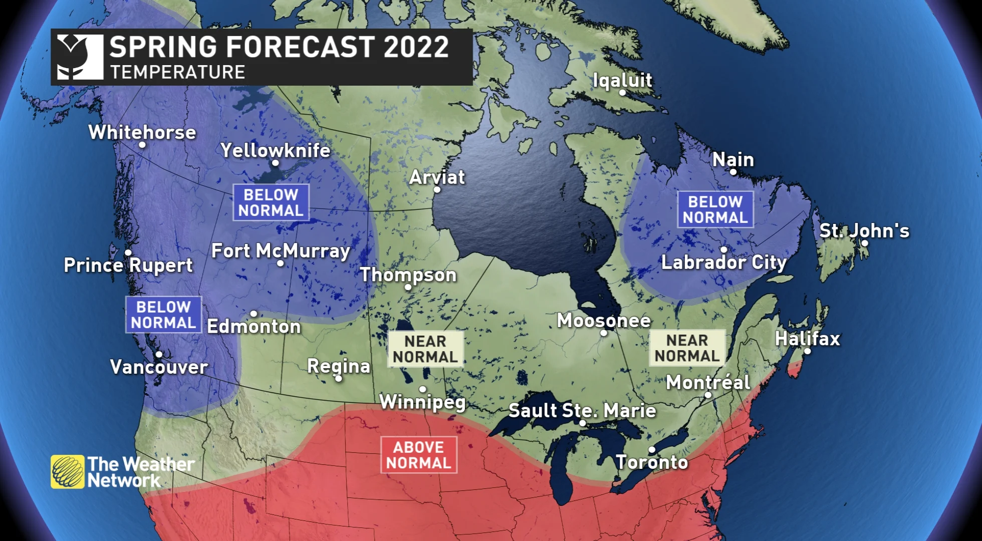
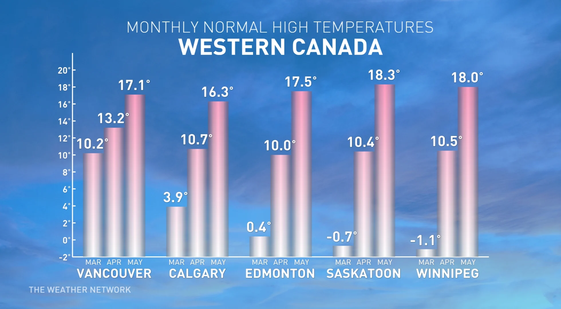
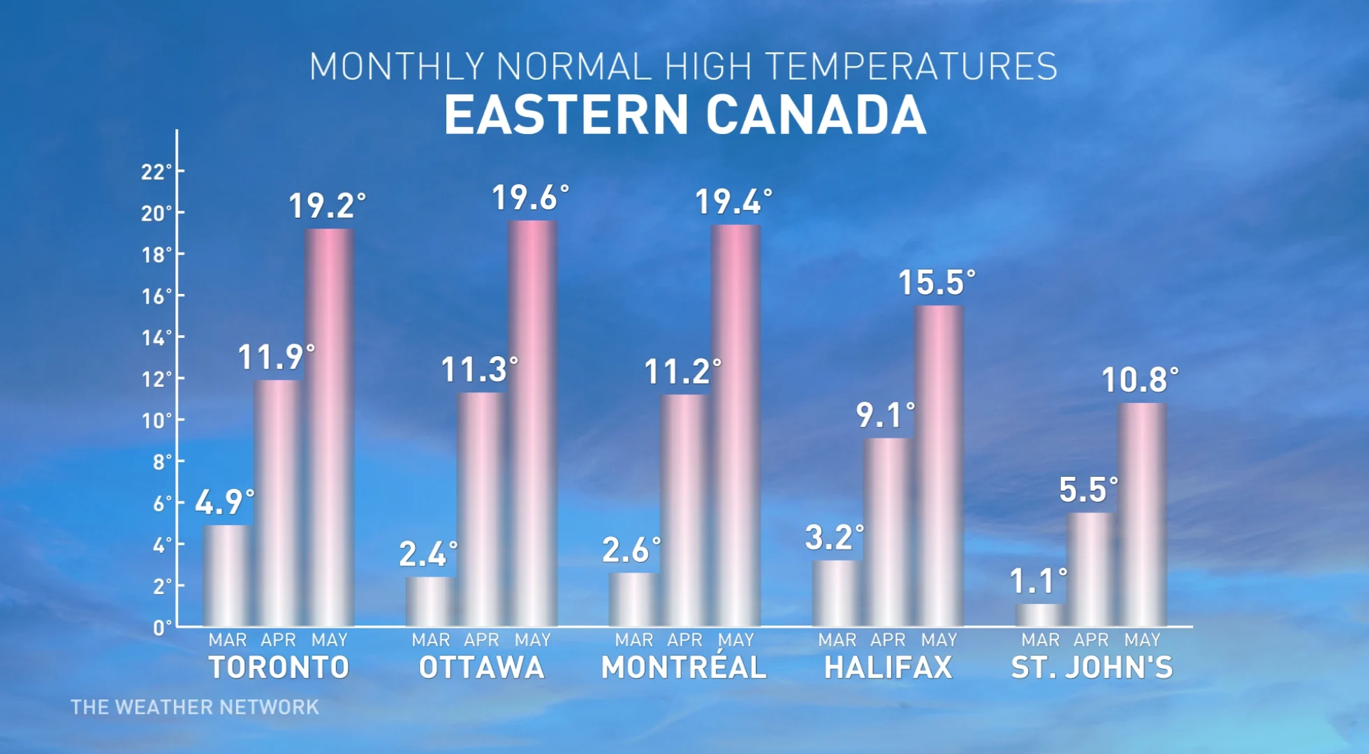
NATIONAL TEMPERATURE PATTERN
The volatile temperature pattern should result in most of Canada seeing temperatures that are near normal or on the cold side of normal for the season. The coldest weather relative to normal is expected across Western and Northwestern Canada, and also across northeastern parts of the country.
Meanwhile, a warmer than normal spring is expected across much of the United States. At times this very warm weather will spread north of the border, and this could tip the Windsor, Ont., area and southwestern Nova Scotia to the warm side of normal for the season. However, even these areas will see some significant setbacks with periods of colder than normal temperatures, especially during the remainder of March and April.
NATIONAL PRECIPITATION PATTERN
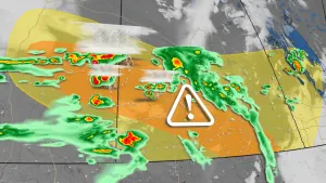
An active storm track should bring near-normal or above-normal precipitation to most of the country. The wettest areas relative to normal are expected to be from Ontario to Atlantic Canada, and of course, some of this precipitation will fall as snow and ice through the first half of the season. We also expect a wet spring across southern and central B.C. with substantial alpine snow.

We do not have any parts of Canada highlighted for a dry spring, but a dry spring is expected south of the U.S. border, and therefore, we will closely watch to see if the very dry conditions expand north into the Prairies. At this point, however, we expect the Prairies will head into the new growing season in better condition than last year.
Despite our forecast for above-normal precipitation for large parts of Canada, the overall threat for spring flooding appears to be somewhat lower this year as periods of mild weather have reduced or eliminated the snowpack in many areas. However, the snowpack is above normal across parts of southern Manitoba (including the Red River basin) and into northern Ontario, so we will closely monitor the risk for spring flooding across these regions.
Below is a more detailed look at the regional conditions expected during March, April, and May:
BRITISH COLUMBIA
Spring usually comes first to this part of Canada. While that will still be the case this year, we expect that our progress through the season will be slower than what we often see across the province, especially during the second half of the season.
However, a positive side to a cooler spring is that this will allow for a more extended spring ski season. Most of the alpine regions have a near-normal or slightly above normal snowpack in place and significant additional snow is expected into April.
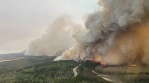
At this point, it does not look like we will see an early start to the wildfire season. While it is too early to discuss the entire summer wildfire season, a cooler and wet spring should at least help delay its start.
WATCH BELOW: COULD B.C.’S SKI SEASON BE EXTENDED?
ALBERTA
The first few weeks of March have provided us with a preview of what we expect for the rest of the season as we have already seen sharply contrasting temperatures patterns with periods of very warm weather and high-impact winter weather.
We expect that this changeable pattern will continue as we head deeper into the spring season, with the ups and downs offsetting each other across southern parts of the province, including Calgary. However, for areas north of Edmonton, we expect temperatures will tip to the cool side of seasonal.
Near normal precipitation is expected across the province, but we will closely monitor southern parts of Alberta where soil moisture is currently well below normal with the approach of another growing season. However, at this point, we are cautiously optimistic that this region will head into the upcoming growing season in better condition than last year.
WATCH BELOW: HOW 'TURBULENT TEMPERATURES' COULD BE IMPACTFUL ACROSS THE PRAIRIES
SASKATCHEWAN AND MANITOBA
There is a heightened potential for turbulent temperatures expected across this region, which typically sees changeable temperatures through the spring season. April is expected to tip to the cool side of normal, while temperatures swings during May should come close to offsetting each other.
Meanwhile, an above-normal snowpack across southern Manitoba provides some good news for agricultural interests, but this also brings a risk for spring flooding. A delay in the start of the planting season and growing season is also a concern.
ONTARIO
Early tastes of warm spring weather will continue to tease at times, but overall, late March and April will test our patience with periods of colder than normal weather and even quick shots of late-winter weather. However, we are optimistic that we will settle into a more consistently warm pattern during the month of May.
An active storm track and a few moisture-laden systems are forecast to bring above normal precipitation to the region. As a result, we are concerned about the potential for a delay in the start of the planting season as fields could initially be too wet for heavy equipment.

While localized spring flooding could still occur, the risk for widespread spring flooding is lower than normal across southern Ontario, as thaws during February and March have wiped out the snowpack already. However, it is a different story across northern Ontario, where parts of the region have a very deep snowpack in place.
WATCH BELOW: WILL THE LA NIÑA PATTERN MEAN MORE PRECIPITATION ACROSS ONTARIO?
QUÉBEC
While March has brought tastes of spring weather, late March and April will test our patience at times with periods of colder than normal weather. This could even include additional high-impact winter weather. However, we are optimistic that May will bring enough warm weather to bring our temperatures to near normal for the season, as a whole, across southern parts of Québec.
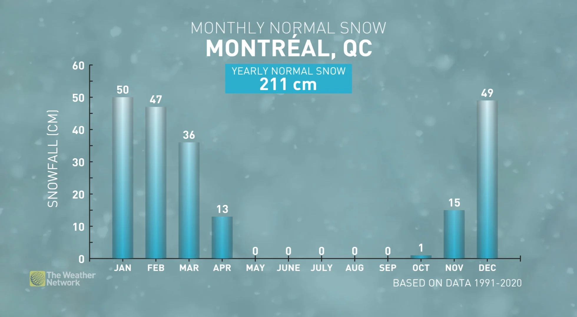
An active storm track and a few moisture-laden systems are forecast to bring above normal precipitation to the region. However, at this point, we do not anticipate a heightened risk for widespread spring flooding as the current snowpack is not exceptional across most of the province.
WATCH BELOW: HOW ICE COULD BECOME AN ISSUE THIS SEASON IN QUEBEC
NEW BRUNSWICK, NOVA SCOTIA, PRINCE EDWARD ISLAND, AND NEWFOUNDLAND & LABRADOR
After a mild winter, this region is settling into a more typical spring pattern with back-and-forth temperature swings that will come close to offsetting each other.
Meanwhile, an active storm track and moisture-laden systems should bring above normal precipitation across the region, including a risk for late-winter-like weather at times.
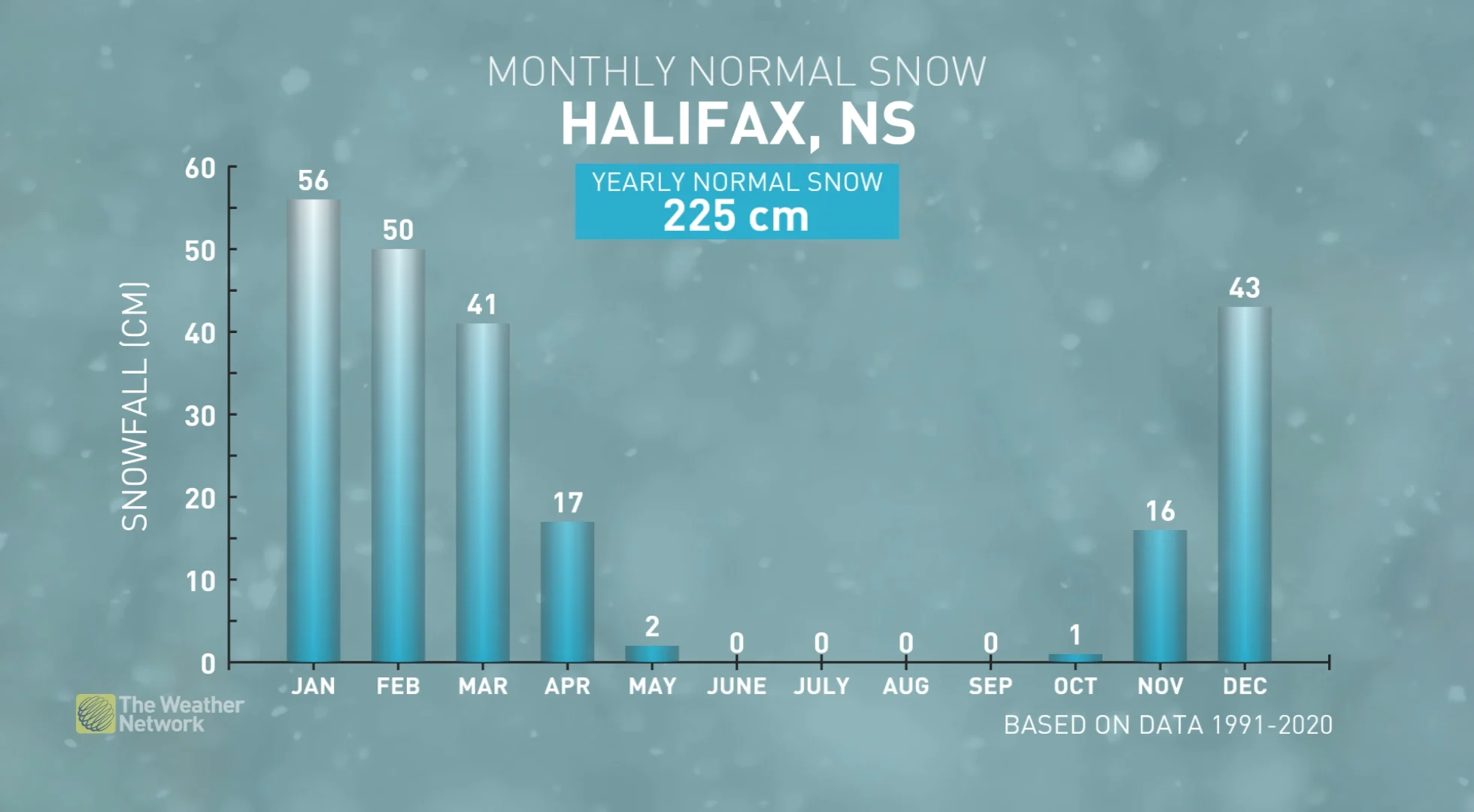
While localized spring flooding could still occur, the risk for widespread flooding appears lower than normal across the region as thaws during February and March have already significantly reduced (or eliminated) the snowpack. However, wet soil conditions could be an issue at the start of the planting season across agricultural areas.
WATCH BELOW: BERMUDA RIDGE AND ARCTIC AIR DUKE IT OUT OVER ATLANTIC CANADA
YUKON, NUNAVUT, AND NORTHWEST TERRITORIES
Colder than normal spring temperatures are expected across the Yukon and the Northwest Territories, while near normal temperatures are expected across Nunavut. Near normal precipitation is expected across most of the region, but southwestern parts of the Yukon territory have the potential to be drier than normal.