Spring 2020: Changeable weather will test our patience

Spring is notorious for bringing changeable weather and this year will be no exception.
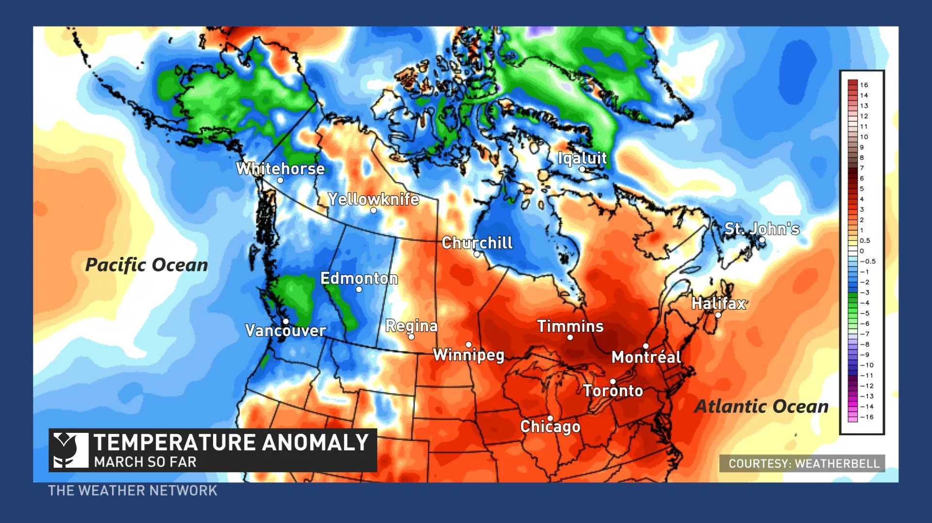
March is living up to its reputation of bringing wild temperature swings and sharp contrasts in temperature across Canada.
Most residents of Canada have enjoyed periods of mild weather during March with just brief shots of colder weather, but parts of western Canada have also experienced a period of severe mid-winter cold and significant snow. Newfoundland has also seen periods of mid-winter like weather.
The map below shows temperature anomalies since March 1st. The various shades of orange and red highlight the warmer than normal temperatures that have dominated from Manitoba to the Maritimes. On the other hand, the various shades of blue and green highlight the colder than normal temperatures that have been found across B.C., Alberta, Newfoundland and parts of northern Canada.
What can we expect for the rest of March, April and May? Please read on!
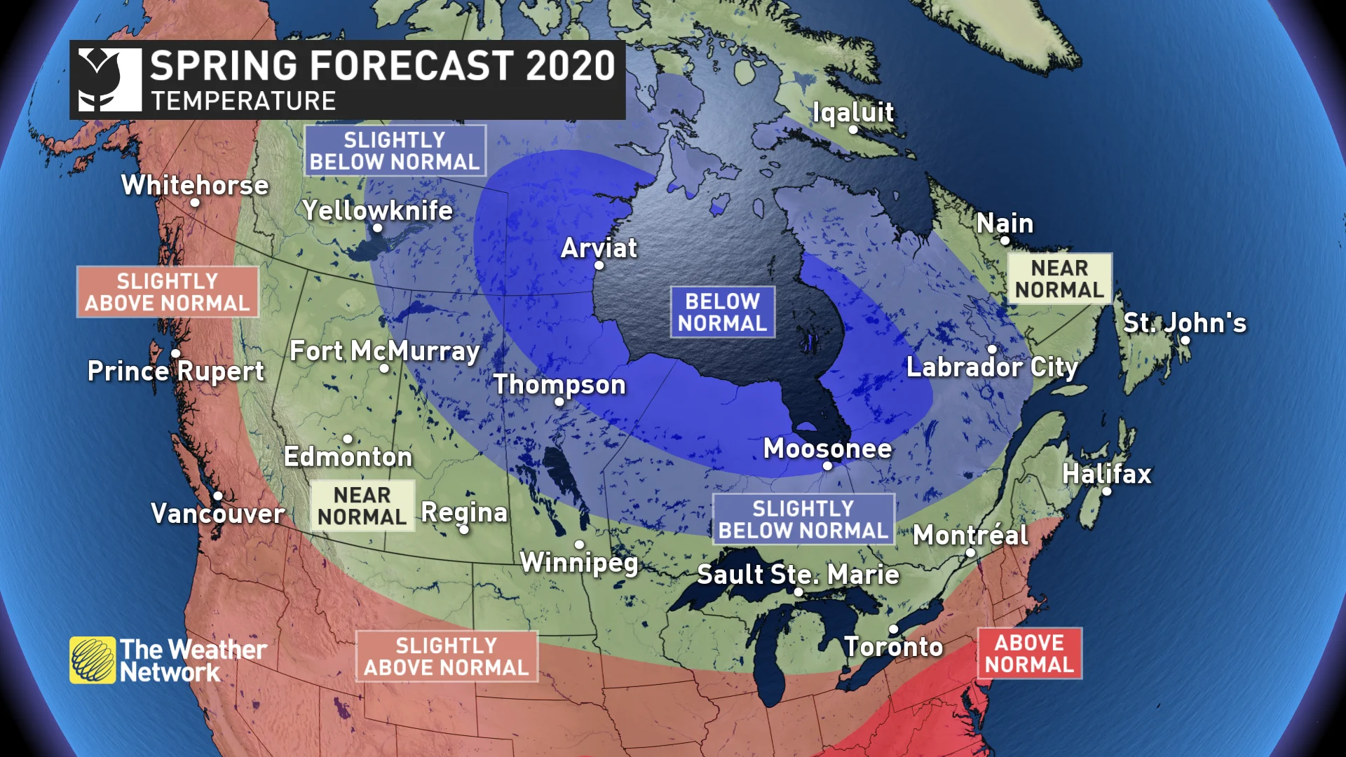
NATIONAL TEMPERATURE PATTERN
Spring will continue to feature the changeable weather that we typically experience during this season of transition from winter to summer. Periods of warmer than normal weather are likely across the country, but interruptions will test our patience at times.
For much Canada, these alternating periods of warm and cold weather will offset each other with near-normal temperatures for the remainder of March, April and May as a whole.
For the eastern half of Canada, this means a warmer spring than the past two years. However, colder than normal weather is expected to be more dominant from northern Saskatchewan to western Labrador and for parts of Nunavut and the Northwest Territories. Meanwhile, temperatures are expected to tip to the warm side of normal across western British Columbia, Yukon and parts of southwestern Ontario.
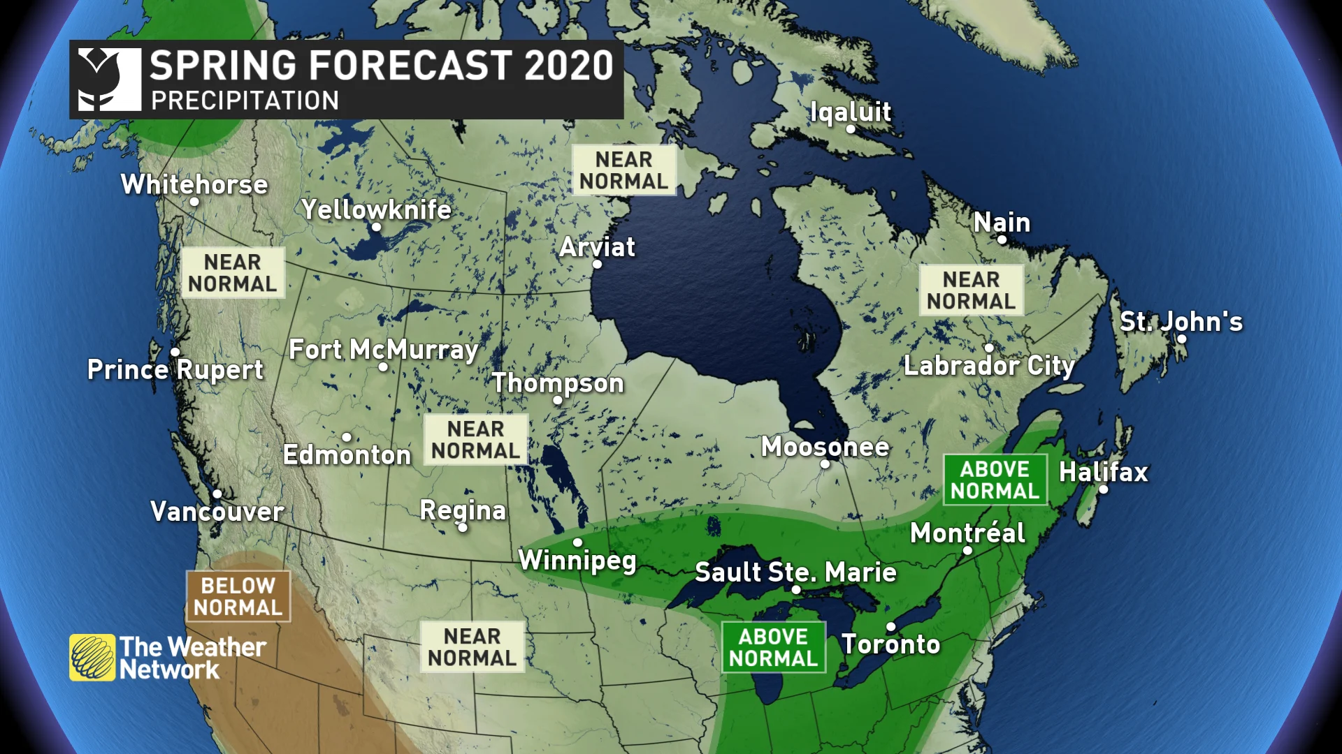
NATIONAL PRECIPITATION PATTERN
Most of Canada is expected to see either near-normal or above-normal precipitation during the spring season. At this point we do not see any long-range signals pointing to widespread dry conditions but we are closely monitoring parts of the southern Prairies which have had a dry conclusion to the winter season.
Wetter than normal weather is expected this spring from the Great Lakes region to the Maritimes. We continue to include parts of southern Manitoba and northwestern Ontario in the “wetter than normal” region, but forecast confidence in this region is lower.
Below is a more detailed look at the conditions that we expect for each region across Canada during the remainder of March, April and May.
BRITISH COLUMBIA
Spring typically comes first to this part of Canada, but so far spring is off to a sluggish start with colder than normal temperatures dominating through March and possibly continuing into early April. However, temperatures are expected to be near seasonal or slightly above seasonal for most of April and May. When warmer weather does arrive, we will have to closely monitor the risk for spring flooding due to the abundance of snow in the alpine regions.
While March has been dry so far, precipitation is expected to be closer to normal during late March through May.
THE PRAIRIES
After a winter lacked consistent cold, this spring will continue to struggle to produce consistent warmth. So far March has brought periods of mid-winter cold, and winter will take a couple more parting shots before we settle into a warmer pattern.
Near-normal precipitation is expected for much of the region. A wetter pattern has been expected to develop later this spring near the U.S. border of Manitoba but forecast confidence is lower in this region. We are also closely monitoring parts of the southern Prairies that have had a dry conclusion to the winter season. We have some concern that those trends could continue if La Niña conditions continue to develop.
Above-normal snow depths on the Rocky Mountains means that we will have to closely monitor the risk for spring flooding along many creeks and rivers in Alberta.
ONTARIO AND QUEBEC
A changeable and wet spring is expected across the region. Temperatures will be colder than normal across northern areas and near seasonal across southern areas, but parts of southwestern Ontario could even tip to the warm side of normal. Overall, temperatures will be noticeably warmer than the previous two springs.
However, interruptions to the milder pattern are still expected before consistent warmth arrives. This spring pattern is somewhat reminiscent of what we saw during the fall which featured extended periods of warm weather, but that was offset by a few weeks of colder than normal weather.
An active pattern should continue to bring above-normal precipitation to the region. This will bring a heightened risk of spring flooding to northern areas that have a deep snowpack and along the shores of the Great Lakes.
ATLANTIC CANADA
Spring will feature the typical back and forth swings in temperature which should come close to offsetting each other. An active storm track will bring near to above-normal precipitation to the region, including a risk for additional late winter-like systems.
As for the threat for spring flooding, the snowpack is currently less than it has been during recent years, contributing less to the threat. However, snowpack is not the only factor when it comes to flooding, especially in New Brunswick. Ice jams, the rate of melt of the snowpack and additional precipitation during late March and April could add to the threat, so that will need to be continuously monitored through the next several weeks.
YUKON, NUNAVUT AND NORTHWEST TERRITORIES
The unusually strong polar vortex is breaking down, but colder than normal temperatures will continue across eastern parts of the region into the start of spring. However, temperatures will trend closer to normal as the season progresses.
Above-normal temperatures are expected to dominate across the Yukon, especially during the second half of the season. Above-normal precipitation is also expected across parts of the Yukon with near-normal precipitation elsewhere.


