Flood, power outage risk rises in B.C. as potent fall storm pushes in
The remnants of Typhoon Bolaven continue to track across the Pacific Ocean, helping to set up the pattern for a strong atmospheric river through Wednesday
A potent fall storm will lash the B.C. coast with extreme rainfall and potentially damaging wind gusts.
The significant storm is being bolstered by the remnants of a typhoon and subtropical moisture that will result in a moderate-to-strong atmospheric river ranking.
DON'T MISS: A ‘historically strong’ El Niño is possible heading into winter
Wind and rainfall warnings are in effect, with some areas potentially seeing 100-300 mm of rain.
Impacts include higher-than-normal water levels and localized flooding, especially around the Vancouver Island and South Coast burn scars. Power outages may also be elevated for some areas.
Wednesday through Thursday morning
A potent atmospheric river sticks around Wednesday, so expect much of the same, soggy weather.
With the amount of moisture and the longer duration of the rain with this atmospheric river, it will be classified as a moderate to strong. For most of the B.C. coast, it will be classified as a Category 3, but for the northern shores of western Vancouver Island, it could be a bit stronger and classified as a Category 4.

Rainfall will be heavy at times, peaking Wednesday afternoon, especially around Tofino. Western Vancouver Island is expected to see 150-300 mm of rain, with areas surrounding Tofino being the heaviest. Rainfall rates could reach upwards to 15 mm an hour for the west coast of Vancouver Island.
Eastern Vancouver Island will have a substantial rain-shadow effect, but will still see 40-75 mm of rain this week. The Sunshine Coast will have 100-150 mm of rain, while the Lower Mainland ranges from 40-100 mm this week.
RELATED: How a super typhoon will alter Canada's late-October weather
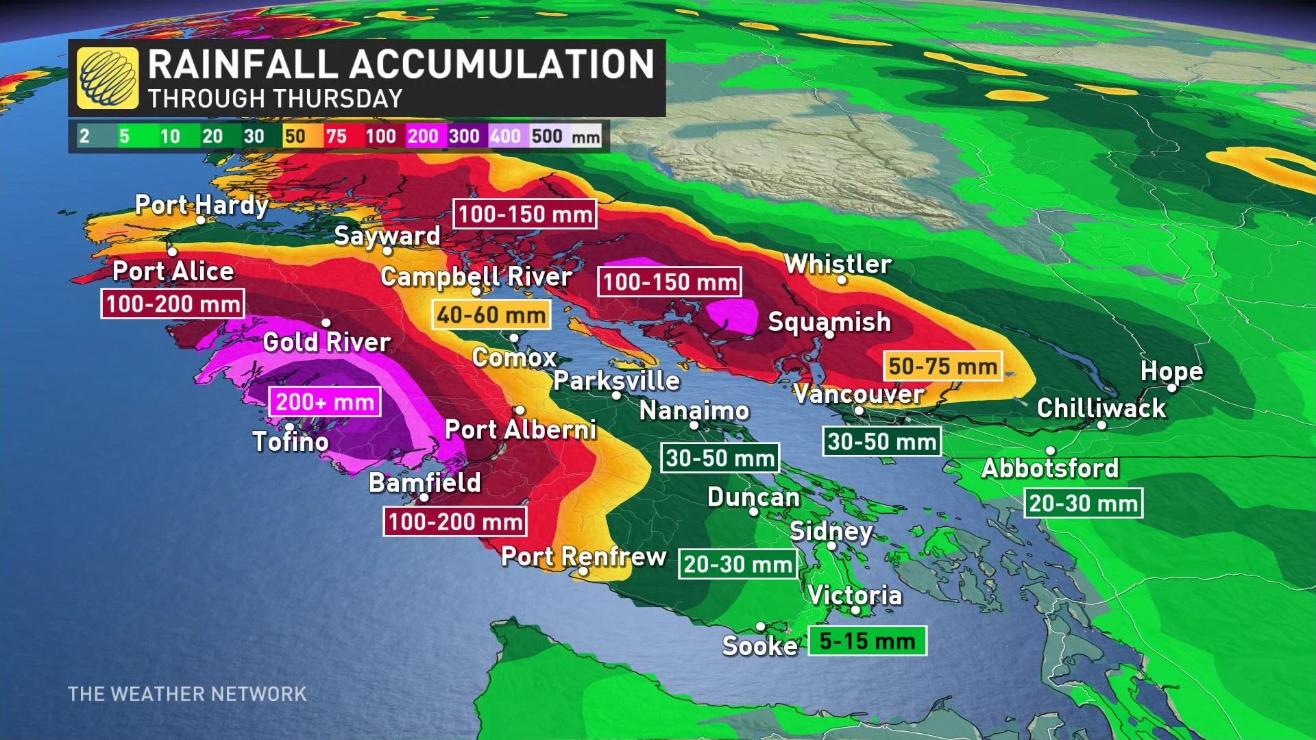
Impacts include higher than normal water levels and localized flooding, especially around Vancouver Island and South Coast burn scars.
There is also the chance of mudslides on Vancouver Island.
Visit our Complete Guide to Fall 2023 for an in-depth look at the Fall Forecast, tips to plan for it and much more!
Relief is in sight but not for another 24 to 36 hours. On Thursday, the heavy rainfall rates will begin to ease into showers for much of the day. The driest day of the week appears to be Friday, with cloudy and unsettled conditions.

Stay tuned to The Weather Network for the latest updates across British Columbia.
Thumbnail courtesy of Alex Dukhanov/Unsplash.