B.C.: New round of storms Thursday ahead of mid-July snow threat

The rain will gradually taper off into Thursday, but B.C. is not quite done with thunderstorms yet.
A potent stream of Pacific moisture has brought some major rainfall to parts of British Columbia, and while there are still a few drops to fall into Thursday, there is also still some thunderstorm risk. Beyond, this unusually wet pattern (for this time of year) is even threatening to bring snow to the Rockies by the end of the week. Details on what to expect, and where.
WEATHER HIGHLIGHTS:
Rain tapers off through Thursday, thunderstorm risk for lower mainland
High elevation snow expected Thursday in the Rockies
For current watches and warnings in your area HERE
WATCH BELOW: THUNDERSTORM ENERGY SPILLS INTO THURSDAY
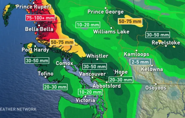
The conveyor belt of moisture that has taken aim at B.C. has been bringing significant rainfall to much of the province, with the northern and central coastlines expected to pick up 100 mm.
The showers were already beginning to ease Wednesday night, though by Thursday morning there could be some lingering rain across the North Coast and Central Interior.

Embedded thunderstorms were one side effect of this system, but Thursday will also feature some scattered thunderstorm risk, particularly through the Fraser Valley, and more widespread rain across the north. This system will also cause a brief cooldown and the majority of the region will experience below-seasonal temperatures.
The good news is that a somewhat warmer pattern will likely develop later next week and should continue into August as well.

MID-JULY SNOW?
This fall-like pattern for B.C. is also bringing an unusual chance of snow in the mountains. Meteorologist Tyler Hamilton notes that there is the possibility for some rare mid-July snow later this week in high elevations of the mountainous regions due to an upper trough setting up the ideal temperatures for flakes to fall.
The abnormally strong jet stream across the international border will allow cold air to pool over the Rockies and southern B.C. for the next couple of nights with the chance for some alpine snow for Banff and Jasper as well.

Stay tuned to The Weather Network for the latest updates.