Bret continues to grow stronger as it approaches Barbados, alerts issued

Bret became the Atlantic's second named storm of the year on Monday, with projections of it strengthening as it continues to trek towards the Lesser Antilles this week
Tropical storms on their own aren’t uncommon in the middle of June, but a system that rolled off Africa and developed deep in the Atlantic became Bret on Monday -- the second named storm of the year -- an extremely rare feat this early in the season.
DON'T MISS: Canada, here's your 2023 summer outlook
The storm has the potential to become the Atlantic's first hurricane in 2023, but there is some uncertainty with how strong it will get.

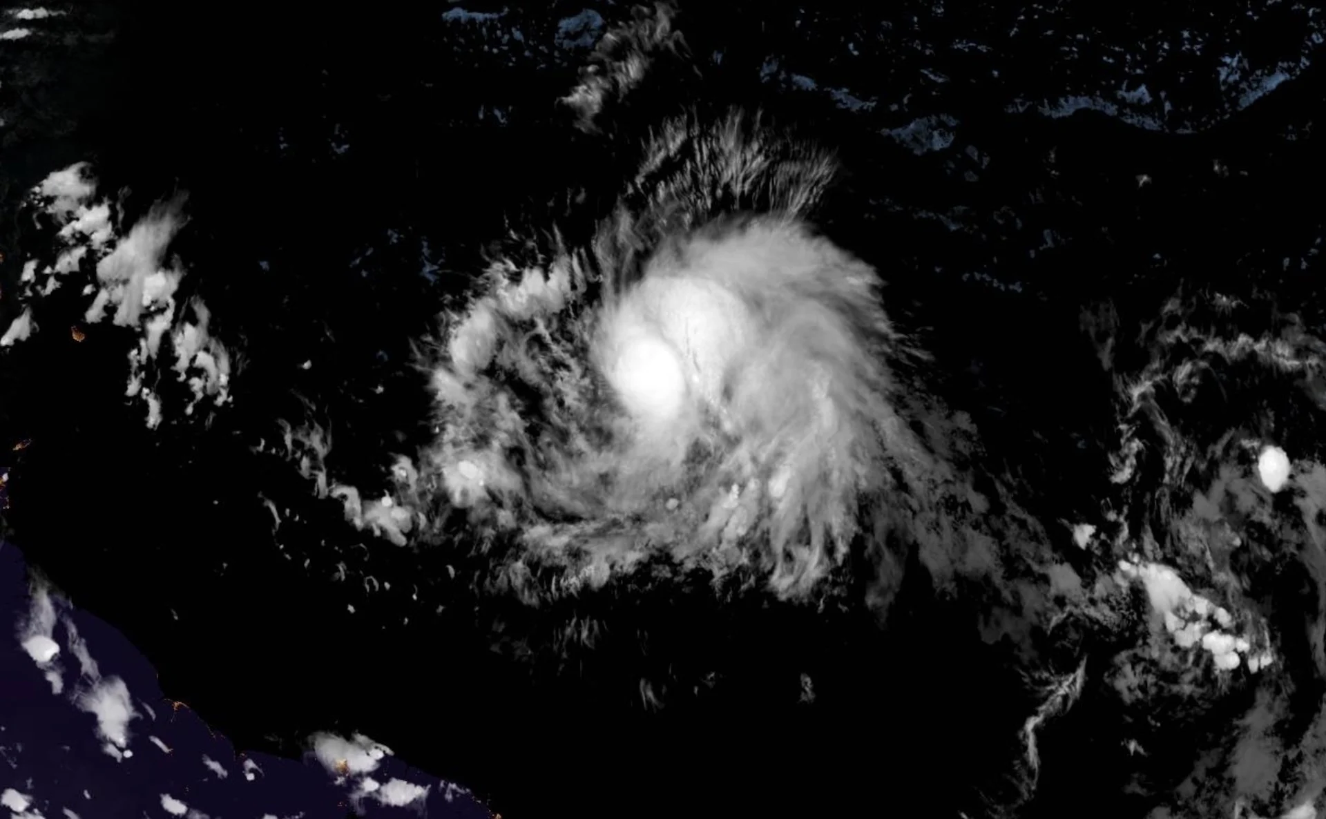
Bret becomes the Atlantic's second named storm this season
Meteorologists with the U.S. National Hurricane Center (NHC) updated the status of the recently minted tropical storm, putting Bret 1,255 kilometres east of the Windward Islands as of Tuesday evening. On the forecast track, forecast track, the centre of Bret is expected move across portions of the Lesser Antilles Thursday afternoon and evening, and then move across the eastern Caribbean Sea on Friday.
Tropical storm watches have been issued for Barbados, Dominica and St. Lucia.
Maximum sustained winds have increased to near 75 km/h, with higher gusts. Strengthening is forecast during the next day or so, and Bret is expected to be a tropical storm when it reaches the Lesser Antilles Thursday. There remains some high uncertainty on whether Bret will reach hurricane status.

The origins of Bret include its start as a healthy tropical wave that rolled off the western coast of Africa late last week.
Unusually low wind shear, decent moisture throughout the atmosphere, and very warm sea surface temperatures are all factors that helped this system defy the odds and become more organized.
A strong ridge of high pressure nestled over the central Atlantic Ocean will steer this system west-northwest through the middle of this week.
Rainfall amounts between 100-150 mm are possible across portions of the Lesser Antilles from Guadeloupe southward to St. Lucia. Between 50-100 mm are possible across Barbados, and St. Vincent and the Grenadines.
"The heavy rainfall could lead to flash flooding, especially across areas of higher terrain," the NHC warns. "Isolated urban flooding is also possible."

Current guidance shows this system could stick around a while. As with any storm, coastal residents from Aruba to the Avalon Peninsula should watch the progress of this system as it moves through the Atlantic Ocean.
Meanwhile, NHC forecasters are also monitoring a tropical wave, designated AL93, located several-hundred kilometres southwest of the Cabo Verde Islands. Showers and thunderstorms have started to redevelop after a lull in activity Tuesday afternoon. Environmental conditions appear conducive for further development of this system, and a tropical depression will likely form during the next couple of days. It has a 70 per cent chance of tropical development in the next 48 hours.
In the likelihood it becomes a named storm, it will be given the Cindy moniker.
Bret is the season's third storm
While this is the season’s second named storm, it’s actually the season’s third storm. Our first system was an unnamed subtropical storm that formed south of Nova Scotia in January. Forecasters didn’t issue advisories on it at the time, opting instead to add it to their records upon reviewing the data in the middle of May.
Temperatures across the entire Atlantic Ocean are much warmer than normal, to an extent that’s surprised many experts who track global ocean temperatures. While a growing El Niño would act to subdue Atlantic hurricane activity under normal conditions, the Atlantic’s unseasonable warmth could counteract that effect and give this season a boost.
MUST SEE: El Niño is here for the summer—but how strong will it grow?
Tropical activity ramps up through the summer months before reaching its peak between mid-August and mid-September, though storms are possible from now through at least the end of November.
WATCH: Will another hurricane hit Canada this year? We have the 2023 outlook
This storm’s location is an extreme outlier in recorded history
It’s quite unusual to have a developing tropical system in this part of the Atlantic Ocean during the month of June. Tropical systems in the Atlantic tend to follow a predictable pattern as the season wears on.
Early-season tropical storms usually develop in the Caribbean, Gulf of Mexico, or far western Atlantic. Cold fronts or thunderstorm complexes rolling off land can stall once they reach these relatively balmy ocean waters, providing the seed needed to develop a weak and short-lived tropical system.

As we get deeper into the summer months, tropical activity reaches farther east into the tropical Atlantic Ocean. The stretch of the Atlantic between the Lesser Antilles and the Cabo Verde Islands is often called the main development region.
The annual monsoon in sub-Saharan Africa allows vivid clusters of thunderstorms to roll off the continent’s west coast on a regular basis.
These tropical waves stream into the Atlantic’s main development region, where the hot summer sun has settled the atmosphere and warmed the surface of the sea, providing the necessary ingredients for storms to develop and flourish.
Only three other June storms recorded this far east
While that’s how things typically go, some storms take advantage of optimal conditions to break the rules and grow into outliers.

Since reliable hurricane records began in the late 1800s, there have only been three other tropical storms that formed this far east in the Atlantic in the month of June.
A hurricane that spun up in the far eastern Atlantic back in June 1933 hit Trinidad, Cuba, and Mexico as a hurricane during its long lifespan. 1979’s Tropical Storm Ana and 2017’s Tropical Storm Bret also formed just east of the Lesser Antilles.
Stay with The Weather Network this hurricane season for the latest information and forecasts.
Thumbnail courtesy of NOAA.