Blizzard conditions ongoing on the Prairies amid potent storm

Prairie drivers beware: blizzard, snowfall, and winter storm warnings continue as the weekend begins
Snowfall warnings stretch from Pincher Creek to Winnipeg this weekend as a robust winter storm straddling the international border blankets the southern Prairies with a dose of heavy snow and high winds.
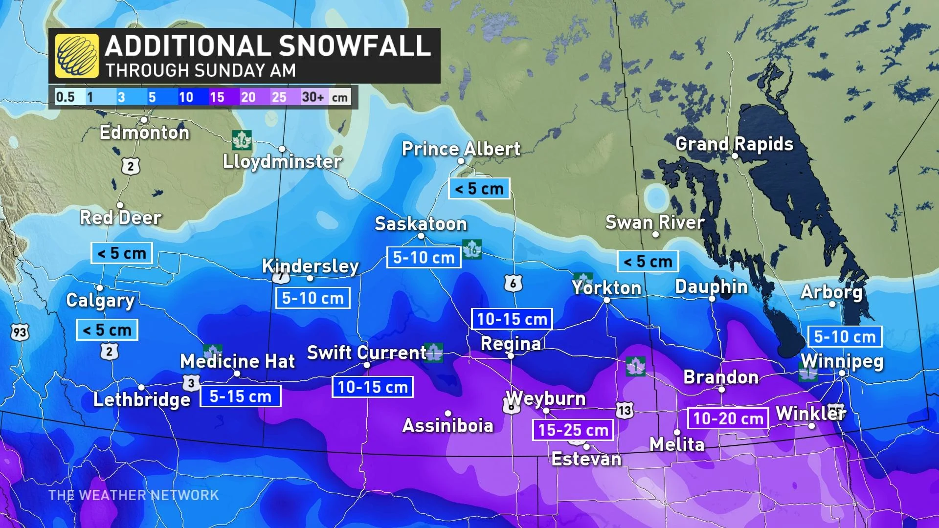
Many communities are on the lookout for 15-25 cm of additional snowfall through Sunday morning.
Visit our Complete Guide to Spring 2023 for an in-depth look at the Spring Forecast, tips to plan for it and much more!
The focus is on southern Saskatchewan, especially, where full-fledged blizzard conditions are possible. Blizzard conditions are occurring across southwest Manitoba throughout Saturday, as well.
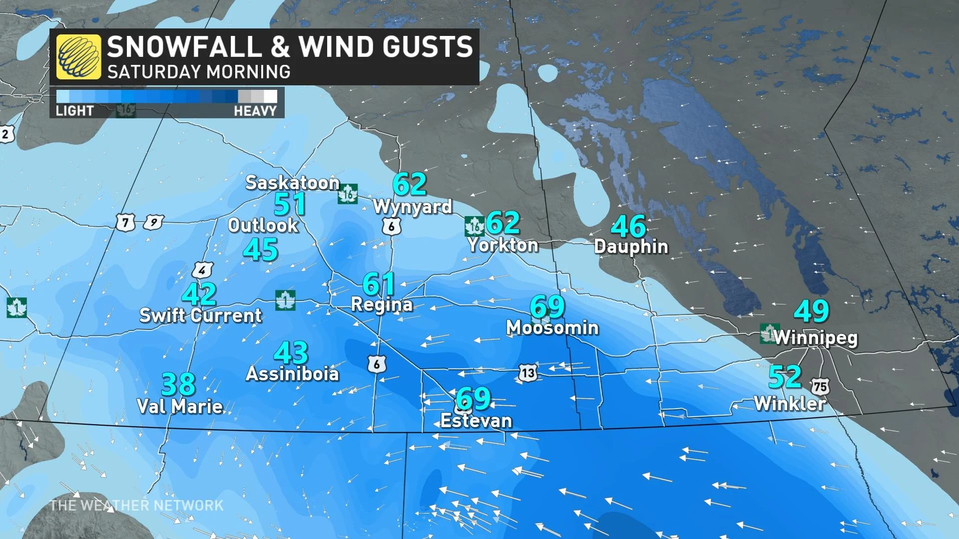
Environment and Climate Change Canada (ECCC) issued blizzard warnings for portions of Saskatchewan, including the City of Regina, as well as the communities of Fort Qu'Appelle, Weyburn, Estevan, Carlyle, and Oxbow.
The combination of heavy snow and gusty winds will lead to low visibility and whiteout conditions through Friday night, and travel is not recommended in these areas as the weather deteriorates.
"Rapidly accumulating snow will make travel difficult," ECCC said in its blizzard warning for Regina.
"Visibility will be suddenly reduced to near zero at times in heavy snow and blowing snow. Prepare for quickly changing and deteriorating travel conditions. If you do travel and become lost, remain where you are until the blizzard has passed."
Snowfall warnings are also in place for southern Manitoba, including the City of Winnipeg.
The system moving into the southern Prairies will feed on tropical moisture pushing in from the Pacific. This moisture, fed by the same atmospheric river bringing a high-risk flood threat to California, will give this Prairie snowfall an extra nudge to produce even higher totals in spots.
Snowfall this time of year often has a tropical connection—and wayward moisture making its way north is a major driver behind March and April typically coming in as one of the snowiest months in Calgary, Alberta.
DON'T MISS: How the tropics help produce big springtime snows on the Prairies
While things wound down in southern Alberta, snow will continue to spread across Saskatchewan and Manitoba through the day Saturday.
In southern Saskatchewan, a widespread swath of 15-25 cm is expected, with 10-20 cm of snow likely across Manitoba. The City of Winnipeg can expect to see between 10-15 cm.
Calmer conditions will arrive by the end of the weekend, with a warmup expected for much of the Prairies by early next week.
Regina and Winnipeg could both see daytime highs climb above freezing by mid-week. This would be the first time Regina’s seen the north side of zero since February 17.
WATCH: Whipping winds cause dangerous travel in Saskatchewan
Be sure to check back for the latest weather updates across the Prairies.