
Swift temperature drop imminent as frigid air spills across Ontario

We’re in for a frigid weekend across Ontario as Arctic air pushes into Central Canada. Forecasters are watching an unsettled pattern next week.
Here comes the cold. A blast of Arctic air will push across Ontario through the day on Saturday, sending weekend temperatures plunging more than 10 degrees below seasonal for the middle of February. Gusty winds will make things feel even colder. The frosty air will stick around through early next week before a pattern change takes hold across the region. More on the weekend cold and a preview of what could arrive next week, below.
DON’T MISS: Here's how to stock your vehicle's emergency kit, BEFORE you get stranded
FRIDAY NIGHT INTO SATURDAY: SNOW LINGERS, ICY ROADS POSSIBLE, TEMPERATURE PLUNGE IMMINENT
We’ll see some lingering snow across parts of Ontario overnight Friday into Saturday morning as a clipper system pulls away from the region. The best chance for additional snow exists near Lake Huron, Georgian Bay, and parts of eastern Ontario still grappling with the tail-end of the clipper.
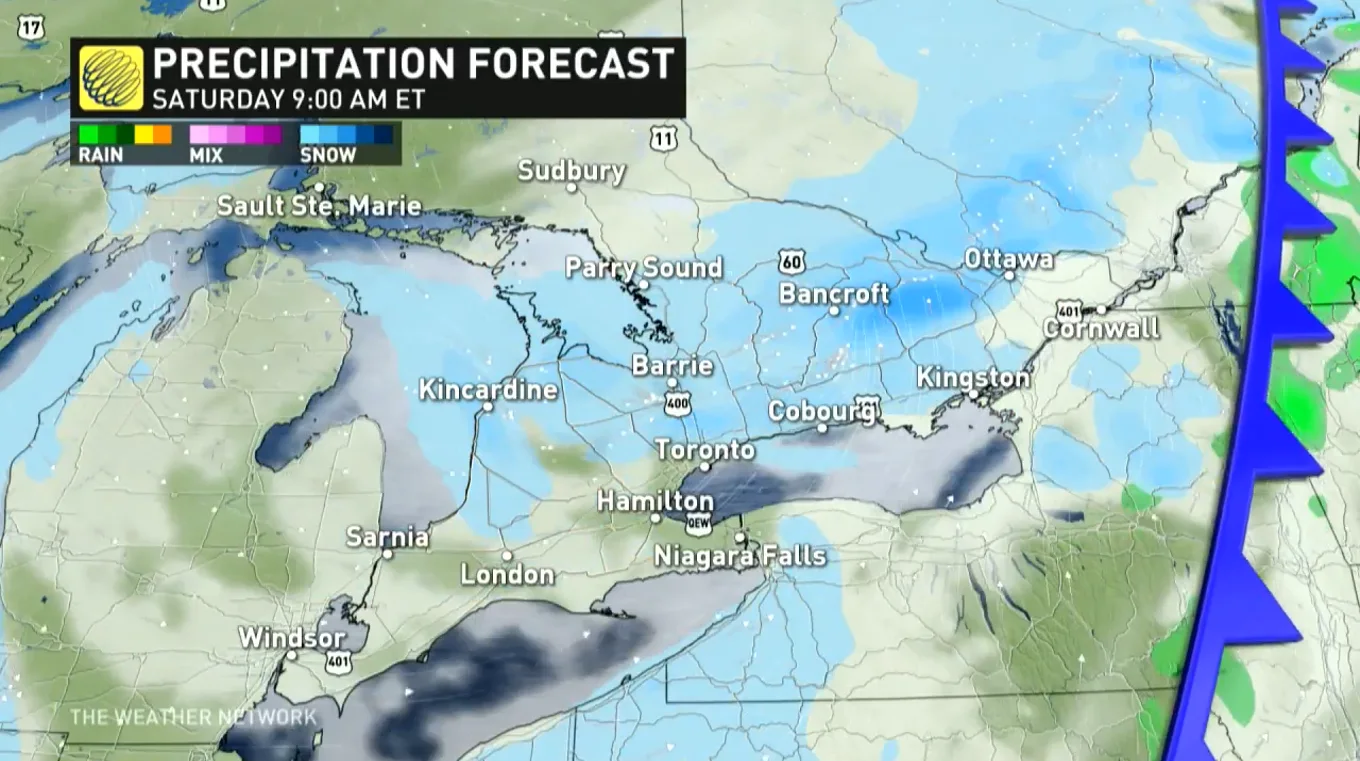
While most areas will only see additional snowfall accumulations that amount to little more than a nuisance, communities along the shores of Lake Huron and Georgian Bay could see a little more courtesy of lake-effect snow showers blowing in with the colder air. This lake-effect snow could continue into Saturday morning.
Slick roads will continue to pose a travel hazard through early Saturday as temperatures fall and any wet or slushy roads freeze.
LOOK AHEAD: FRIGID WEEKEND AHEAD, POTENTIAL UNSETTLED PATTERN NEXT WEEK
Colder air flooding in behind the clipper will send temperatures plummeting through the day on Saturday. Most areas will see the day’s high temperature occur early on Saturday, with temperatures steadily falling through the day behind the cold front.
We’ll see such a sharp drop in temperatures that there are even flash freeze warnings in parts of Quebec. The risk for a sudden freeze extends into parts of central Ontario, as well, where temperatures around freezing on Friday evening fall into the negative teens before sunrise.
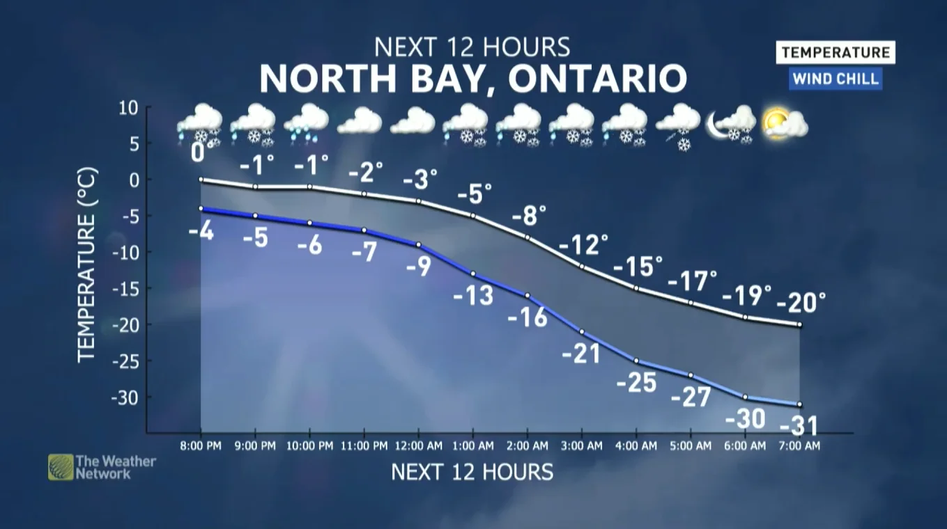
North Bay’s forecast through pre-dawn Saturday tells the brutal tale of the Arctic air. A steady temperature around the freezing mark Friday evening enters into a freefall that reaches -20°C with a -31 wind chill value by 7:00 a.m.
Winds could gust as high as 60 km/h across southern Ontario during the day on Saturday, with gusts calming down by nightfall. The winds will make the cold air feel even more unpleasant.
Sunday is going to be downright cold, with frigid daytime highs expected to dip into the minus double digits across the region. Subfreezing daytime highs and even colder nighttime lows will continue to bathe Ontario through Tuesday.

Milder air will begin to push into southern Ontario by Wednesday, and the arrival of more agreeable temperatures will portend a more unsettled pattern heading into the latter half of next week.
PLAN AHEAD: Winter loosens its grip in Central Canada, but it's not over, yet
A boundary setting up across the Great Lakes through southern Quebec will act as a battleground between mild air to the south and colder air to the north. This stark temperature divide will serve as an active storm track that could see one or more systems trek across the region late next week.
Southern Ontario and southern Quebec could see rain, possibly heavy, followed by the potential for ice and snow. Heavy snow is possible for the northern Great Lakes and central Quebec.
Keep the storm risk on your radar and plan accordingly as we head into next week. Stay tuned to The Weather Network for all the latest as forecasters get a clearer idea of how next week’s storm threat is shaping up.

The milder pattern we’ll experience next week has the potential to linger through the remainder of February. While winter isn’t coming to an end, this pattern shift might signal that we’ve turned the corner on the slow but steady climb toward longer days and the spring equinox in March.
Subscribe to 'This Day in Weather History': Apple Podcasts | Amazon Alexa | Google Assistant | Spotify | Google Podcasts | iHeartRadio | Overcast'
Check back for the latest forecast across Ontario.