B.C. 'weather bomb' will bring heavy rain, strong winds, and snow

The unsettled trend will continue in B.C. for the foreseeable future with waves of moisture bringing copious amounts of rainfall for the South Coast, blustery winds, and considerable amounts of snowfall for the mountain passes.
A significant wave of moisture will push through southern British Columbia on Monday morning and many will see heavy rain and snow in higher elevation areas. Some regions will see a break from the soggy weather during the day but another round of moisture will quickly track in. More on the blustery conditions, and what to expect later on in the week, below.
Visit our Complete Guide to Fall 2021 for an in-depth look at the Fall Forecast, tips to plan for it and much more!
MONDAY: ROUNDS OF RAIN, SNOW, AND INTENSE WINDS
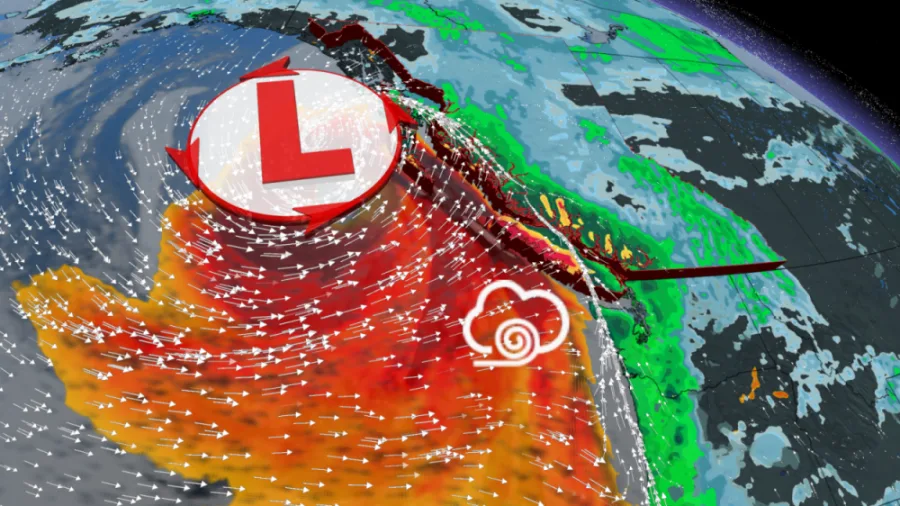
The broad upper trough that is sitting over the Gulf of Alaska will continue sending low pressure systems towards the Pacific Coast. A potent system that will reach B.C. during the pre-dawn hours on Monday will rapidly intensify and reach ‘weather bomb’ status. A system becomes a ‘weather bomb’ when the pressure drops at least 24 millibars in 24 hours.
"We have our third ‘weather bomb’ (bombogenesis) in less than three weeks about to rapidly intensify. Proximity to northern Vancouver Island means this will be quite the windstorm for some,” says Tyler Hamilton, a meteorologist at The Weather Network.
A heavy round of rain will track in during the pre-dawn hours Monday morning and push precipitation northward along the coast through the day. During this time the Lower Mainland will see a bit of break from the precipitation.
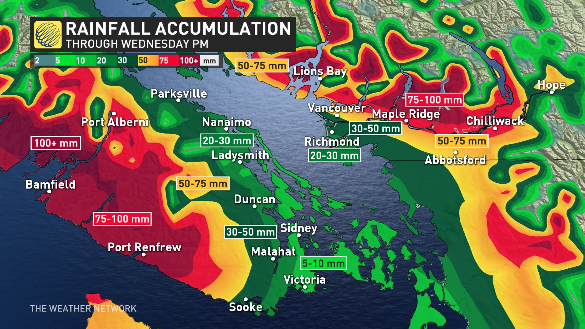
Rain will approach the northern tip of Vancouver Island on Monday night and will generate strong southeast winds ahead of its arrival. Special weather statements are in place. Through Tuesday, accumulative totals up to 60 mm are anticipated for Metro Vancouver.
The average total for November is 188 mm, meaning it is the wettest month of the year for the city. Areas along the southwestern coast of Vancouver Island could see 100+ mm of rainfall during the same time period.
RELATED: 'Ultra-rare' November tornado hits Vancouver, B.C., damage reported
Strong southeast winds of 50-80 km/h are expected, except for exposed coastal sections of western Vancouver Island where winds will veer to a westerly direction, reaching 70-90 km/h, while outer coastal regions could see over 100 km/h gusts. Communities adjacent to the Strait of Georgia, Haro Strait, Juan de Fuca Strait and exposed coastal sections of the west coast of Vancouver Island will be impacted.
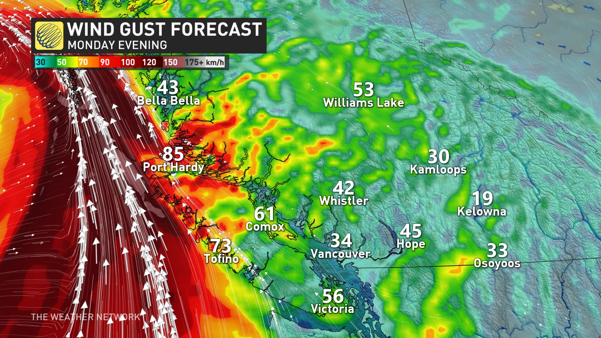
“A rapidly deepening weather system will generate strong southeast winds over the west coast of Vancouver Island, Central Coast and Haida Gwaii beginning Monday evening. The southeast winds will quickly progress into the inner south coast waters. The weather system will remain very intense Tuesday and these blustery conditions are expected to continue,” states Environment and Climate Change Canada (ECCC).
“The exact track and strength of the weather system is still uncertain. Any changes in the evolution of this system can affect the timing and strength of the winds. As the event nears, wind warnings may be issued.”
In addition to the rain, the persistent train of storms along the coast has allowed Arctic air to reach southern B.C. Freezing levels won't lift above 1000 metres until the middle of next week, even dropping to 400 metres overnight.
Snowfall will be a given for the mountain passes, with accumulations of 5-15 cm through Monday. This will make for difficult travel in these regions. Because of the lower freezing levels, there will be the chance for mixing to reach some of the higher communities along the periphery of the Lower Mainland.
ON CAMERA: RARE TORNADO HITS VANCOUVER, CAPTURED BY MULTIPLE WITNESSES
LOOK AHEAD: RAINY PATTERN CONTINUES, ALONG HEFTY AMOUNT OF ALPINE SNOW
A colder pattern will continue in B.C. for most of the week, along with no stopping in the parade of storms for the South Coast.
Seven-day rainfall totals continue to be 70-150 mm for the Lower Mainland, including Metro Vancouver, and 150-300 mm for the higher terrain and west coast of Vancouver Island.
The low north of Vancouver Island will eventually die out by Wednesday but a high pressure south of the border will redirect some residual moisture into the South Coast as it runs into that cold air.
Freezing levels will remain low this week and that means more snow for many ski areas including Whistler, with higher accumulations for the higher alpine. The North Shore Mountains may see 100 cm through Wednesday.
Heavy snow for the North Shore ski areas, as well, and very difficult travel is expected through the mountain passes. Some snow will even make it to the valley floors of the Interior.
Be sure to check back for the latest updates on the weather in B.C.


