Atmospheric traffic jam to please some, disappoint others across Eastern Canada

While some will have pleasant, sunny weather for the weekend, others will be bogged down in chilly rain across Canada's eastern provinces.
A traffic jam in the atmosphere will lead to the saying ‘what you see is what you get’ when it comes to your forecast in Eastern Canada over the next few days.
An omega blocking pattern will develop in the upper levels of the atmosphere leading to a somewhat ‘stalled’ weather pattern with some areas expected to experience several days of rainy weather, while others will escape with fair conditions and lots of sunshine. Which side of this pattern will you fall on? Read on to find out.
DON'T MISS: Lyrid fireballs may light up your night sky this weekend. Here's how to watch
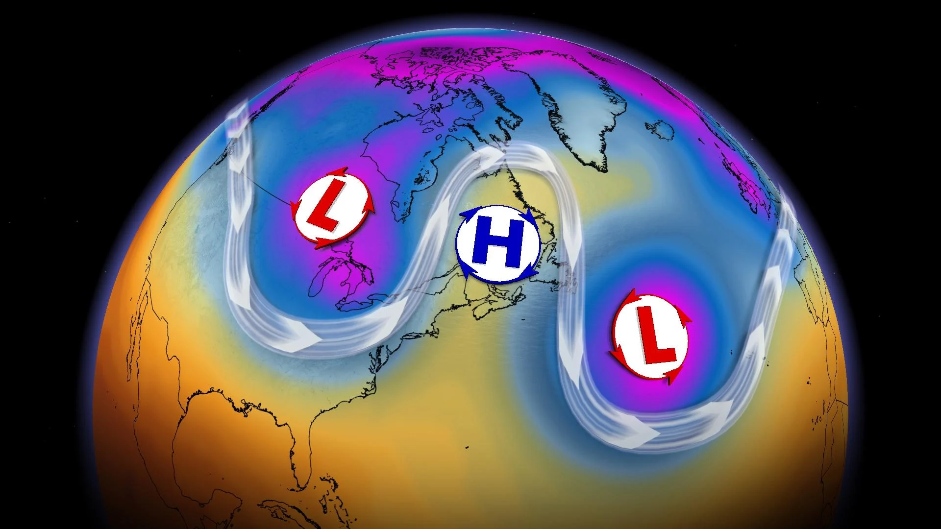
Omega block
Atmospheric patterns can take different forms and shapes. Across Eastern Canada over the weekend, we are going to be seeing the impacts of what is called an ‘omega block’.
This atmospheric pattern can be quite stubborn to move; it can make some quite happy about the forecast, and others, not so much.
An omega block takes form high up in the atmosphere, where high pressure becomes sandwiched between two areas of low pressure. The troughs and ridges that settle in take the shape of the Greek letter omega.

Soggy days ahead
Much like a trough on a house, these troughs funnel precipitation. Unfortunately, the atmosphere is not a house and it funnels the precipitation directly onto those within it, rather than away.
That means soggy and gloomy days are ahead for those located within the trough. This will be much of Ontario and Quebec through the weekend as an upper-level low spins stationary over the region.

How the precipitation will fall will depend on temperatures. Areas with cooler temperatures will likely see snow, while areas with warmer temperatures are going to see rain.
What also might be a bit unusual is the movement of precipitation. We know weather systems usually travel west to east, but in this case with the blocking ridge, precipitation might appear to move from south to north if you take a glance at the radar over the weekend.
ALSO READ: Road closures escalate as flooding reported in 5 areas of New Brunswick
Fair and sunny
In sharp contrast, those within the high-pressure ridge are going to have much more pleasant days ahead. You could think of it like being on a ridge or hill to avoid the water below.

A stationary upper level high is going to bring sunny days galore and fair, spring-like temperatures through the next few days. This pleasant weather will be sitting over the Atlantic provinces, except for Newfoundland which is caught in its own trough.
These provinces are definitely where you will want to be for the next few days, especially since this pattern will be stalled over Eastern Canada for the next little while.
How long will it last?
Blocking patterns can be notoriously tough to shake, and this one may be hanging around through the first half of next week. That will leave cloudy and rainy skies in place for places like Montreal, where temperatures may linger in the single digits until Wednesday.

On the flip side, northern locations in Eastern Canada will continue to bask in unseasonal warmth - at least those that aren’t exposed to on-shore flow off the chilly North Atlantic.

Unlikely locations including Happy Valley-Goose Bay will see temperatures boosted into the double digits, which is more than five degrees above normal for late April.
Keep checking back to The Weather Network for more forecast information for Eastern Canada.