Newfoundland: Storm ushers in hefty shot of snow, heavy rain and strong winds

A significant winter-like storm is now bringing heavy snow, strong winds and rain to Newfoundland through early Monday morning
Newfoundland will be dealing with most of the effects of a system tracking south of Atlantic Canada Sunday, as snow pushes out of eastern Nova Scotia. Heavy snow, rain and strong winds will be the impacts for the province through the day, with some lingering effects into pre-dawn hours Monday. Winds will also be blustery in southern Nova Scotia Sunday. Details and timing, below.
WEATHER HIGHLIGHTS:
Effects wind down for Cape Breton in Sunday morning, ongoing in Newfoundland through early Monday morning
Interior Newfoundland to see heavy snow, rain for the Avalon
Winds of 60-80 km/h expected, possible 100 km/h in coastal Newfoundland
Keep on top of the latest weather ALERTS in your area
SUNDAY: STORM IMPACTS MOVE THROUGH NEWFOUNDLAND
Effects from the low have pushed into Newfoundland, as snow is winding down in eastern Nova Scotia Sunday morning.
Initially Halifax was on the edge of either receiving a considerable amount of snow or getting just a little, and the latter has proven true. The city will pick up no more than 4 cm or so from this entire system, with the low remaining offshore. Cape Breton was a different story, and southern areas will have picked up 10-20 cm of snow while 5-15 cm is expected for northern sections by the time it eases off.
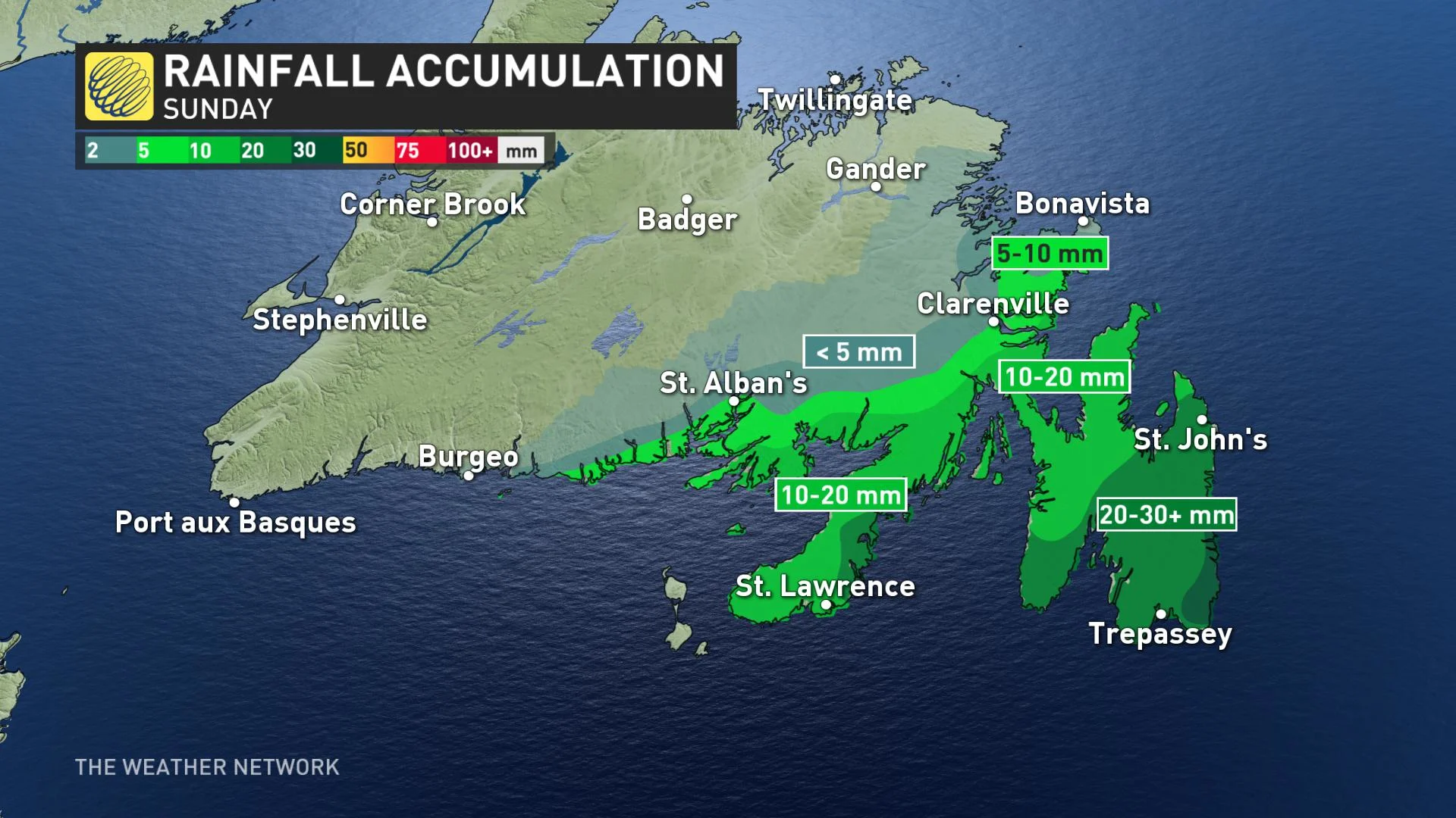
The storm's effects started in Newfoundland overnight and will continue Sunday. The heaviest amounts are expected to be inland, with some 20-30 cm possible for areas north of the south coast, but amounts will still be hefty for most places, including the Avalon, parts of which are still on track to receive as much as 15 cm from this system.

Precipitation has started out falling as snow in much of Newfoundland, but will eventually switch to a rain/snow mix for the Burin, Avalon and Bonavista late morning into early afternoon. A transition to periods of rain for the aforementioned areas will occur through the afternoon hours.
The Avalon will see more rain than snow with this low, possibly picking up as much as 30+ mm for southern parts of the peninsula, while the rest of the region, along with the Burin, are in the 10-20 mm range. Beyond those areas, amounts will be quite low.
A switch back to a brief rain/snow mix is possible overnight Sunday before it wraps up in the pre-dawn hours Monday for most areas, except for western mountain ranges.
Wind gusts of 60+ km/h are expected along the coast in the Halifax area Sunday, with higher speeds of up to 80 km/h along the shores of southern Cape Breton through the evening. Winds will begin to intensify in Newfoundland in the afternoon, hitting 80-90 km/h, and as high as 100 km/h, in the Avalon and coastal areas, before easing off early Monday morning.
The unsettled weather will continue next week, as another low threatens a Monday night into Tuesday impact.
NEXT WEEK: UNCERTAINTY WITH INCOMING LOW
Monday will be mainly dry for the Maritimes, with temperatures in the double digits. Clouds will increase late in the day as the next system will track south of the Atlantic into Tuesday, further than previously forecasted, but will still be close.
Like with the weekend system, there is uncertainty in its track. If it shifts even slightly to the north, the southern Maritimes and parts of Newfoundland may get wet snow, but wind won't be an issue.
Check back for updates as we continue to monitor the forecast.