April features a classic duel between winter and spring

We break down what you can expect weather-wise across Canada in April.
Most of us associate April with warmer weather and the emergence of spring flowers. But we all know that April can still deliver late winter-like weather and this year will be no exception.
However, before we dive into the details, let’s take a quick look back at March. Spring has gotten off to a sluggish start across Western Canada. The map below shows temperature anomalies for March 2020 and the various shades of blue and green highlight the colder than normal weather that was found from British Columbia to central Saskatchewan.
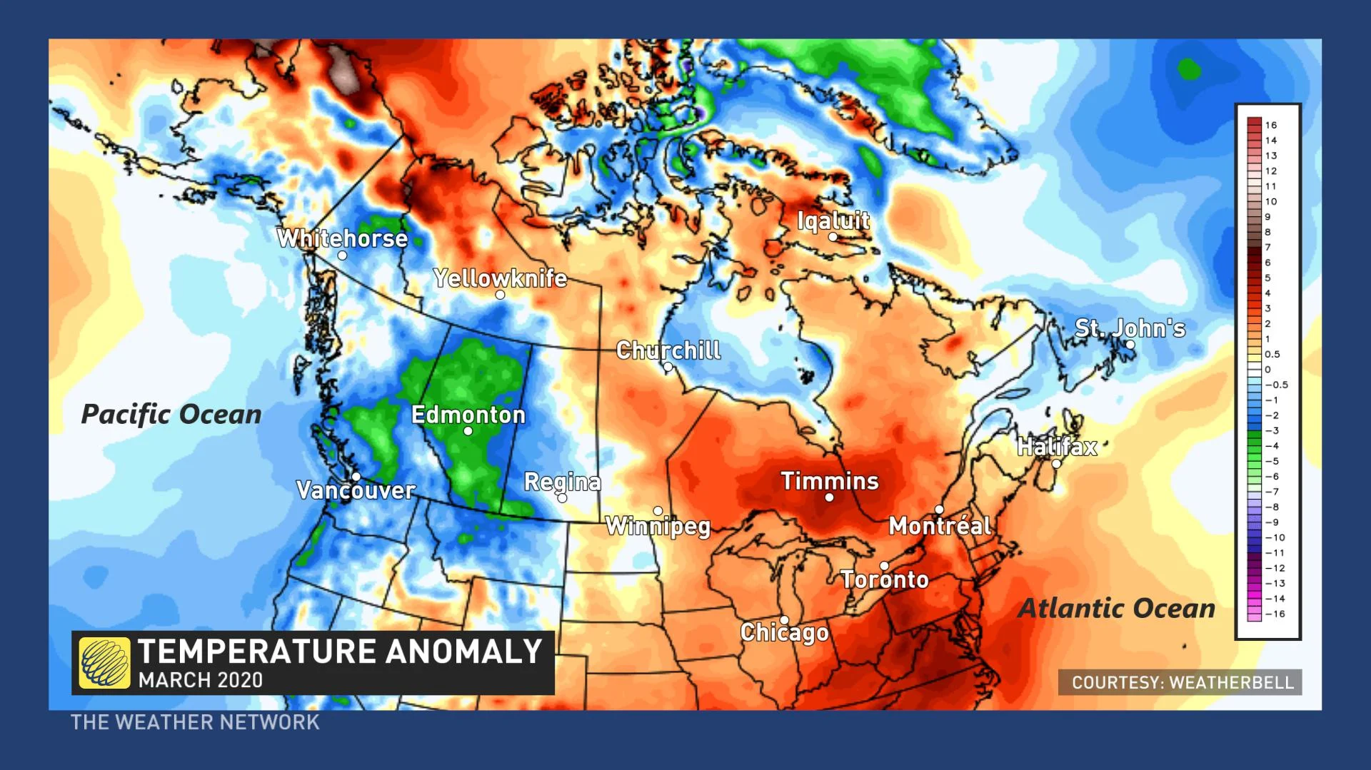
In addition, Newfoundland had a chilly March. While each of these areas have seen some mild days, winter weather out duelled spring weather for the month as a whole. Meanwhile, the region from Manitoba to the Maritimes has had a warmer than normal March. This area saw some high-impact winter weather at times, but mild temperatures were more dominant.
RELATED: Spring 2020 will test our patience
Now as we look ahead to April, it looks like the dominant pattern across Canada will resemble what we saw during March. Please read on for more details.
EARLY APRIL PATTERN
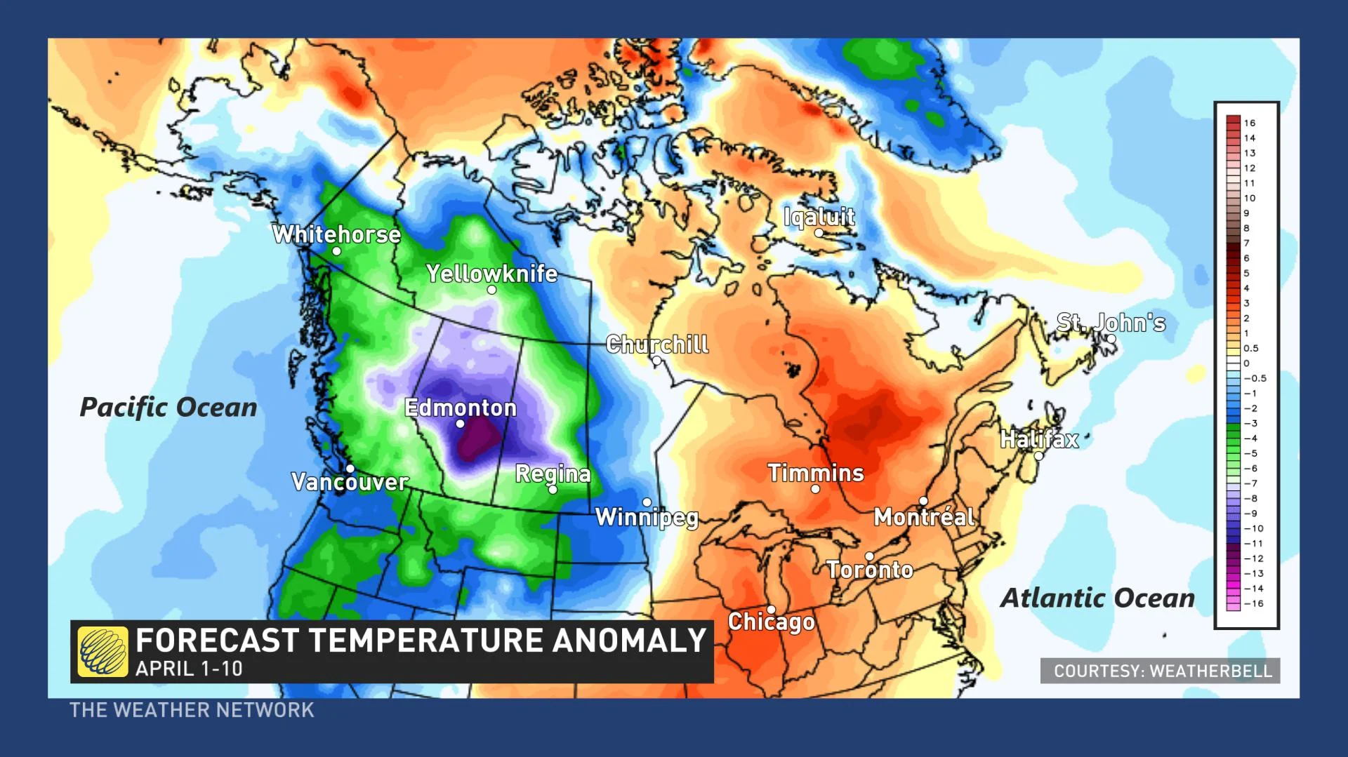
April will pick up where March left off across the Prairies with more winter-like weather. The coldest weather relative to normal will be found across Alberta, but chilly weather will dominate from B.C. to western Manitoba.
The map below shows a model forecast for temperature anomalies during the first 10 days of April. The various shades of blue, green and violet highlight the areas that are expected to be colder than normal during early April. We also expect that most of Newfoundland (especially eastern areas including the Avalon) and the eastern Maritimes will be on the cool side of normal. Meanwhile, warmer than normal weather is expected across Ontario, Quebec and into the western Maritimes.
SHIFT IN THE PATTERN FOR MID-APRIL
As we head deeper into April, we are watching the increasing potential for the chilly weather to shift east. We expect that this will bring a period of colder weather into Ontario and Quebec, and allow for a period of milder weather for parts of Western Canada. However, we expect that this pattern change will be temporary.
WATCH BELOW: AREAS MOST AT RISK OF SPRING SNOWFALL
FAMILIAR PATTERN FOR LATE APRIL
As we head into late April and into early May, we expect that a warmer than normal pattern will return to most of Ontario, southern Quebec, where we could see some very warm temperatures by the beginning of May. This will be quite a contrast to the very chilly weather that this region experienced during the last two springs. The warm weather could also reach into the Maritimes.
Meanwhile, much of Western Canada is expected to be cooler than normal. However, we should keep in mind that “normal” temperatures rise by 5°C to 10°C across the country during April.
GREAT LAKES: Lack of ice, high water levels will have spring consequences
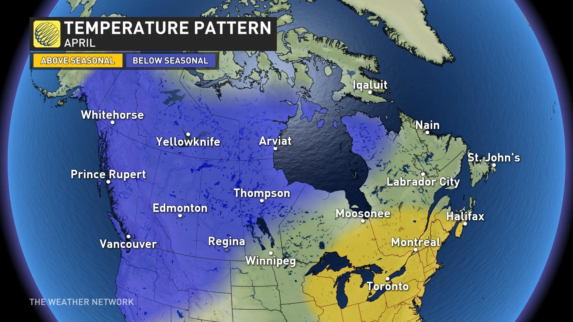
MONTHLY SUMMARY FOR APRIL
So, when we look at the month of April as a whole, we expect that the overall pattern will resemble what we saw during March, but of course the actual numbers will be warmer. While everyone will see back-and-forth swings in temperature, Western Canada will likely tip to the cold side of normal, while the Great Lakes region to the western Maritimes are expected to be warmer than normal. Near normal temperatures are expected for southern Manitoba, northwestern Ontario, the eastern Maritimes, Newfoundland and Labrador.
