A southeast U.S. soaker will send tropical moisture to Atlantic Canada next week

A tropical disturbance in the Gulf of Mexico is on the cusp of tropical storm status as it moves into Louisiana. The system will drench the southeastern United States this weekend, and its moisture could bring heavy rain to Atlantic Canada by the middle of next week.
A tropical disturbance in the Gulf of Mexico might develop into the third named storm of the Atlantic hurricane season on Friday night as it nears landfall in Louisiana. The disturbance will bring a risk for significant rainfall to parts of the southeastern United States this weekend. The system’s remnants will then travel up the U.S. East Coast, the moisture from which could reach Atlantic Canada by the middle of next week and provide the opportunity for heavy rains in the region.
THE SYSTEM IS CLOSING IN ON LOUISIANA
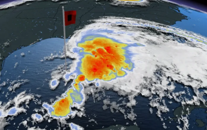
The U.S. National Hurricane Center (NHC) declared the disturbance in the southwestern Gulf of Mexico a “Potential Tropical Cyclone” on Thursday evening, a special designation that alerts coastal residents that a tropical cyclone is predicted to form and hit land within the next 48 hours.
It's possible that the system won't organize enough to become Tropical Storm Claudette by the time it reaches Louisiana early Saturday morning. However, the disturbance will have the same impacts in the United States regardless of whether forecasters officially declare the system a tropical storm and assign it a name.

Winds of 70-75 km/h began to buffet the northern Gulf Coast on Friday evening. A tropical storm warning is in effect for parts of the Louisiana, Mississippi, and Alabama coasts as the system's thunderstorms draw closer to shore.
THIS WEEKEND: FLOODING RAINS A SERIOUS THREAT FOR GULF STATES
Gusty winds could lead to tree damage, power outages, and minor coastal flooding from storm surge in communities along the northern Gulf Coast as the system pushes inland. Tornadoes are also possible, a common threat for any landfalling tropical disturbance. The U.S. Storm Prediction Center said Friday evening that the tornado threat will peak on Saturday in southern Alabama and the western part of the Florida Panhandle.

While blustery winds and the potential for tornadoes are hazards for communities in and near the storm’s path, flooding rains are far and away the greatest threat. The system is expected to produce heavy rainfall and flash flooding in the southeastern states, continuing through the weekend as slug of tropical moisture heads toward the Carolinas.
Rainfall totals of 75-100 mm are possible in portions of Alabama, Florida, and Georgia as tropical downpours cover the region over the next couple of days. Some spots could measure more than than 200 mm of rain by the end of the storm.

The swampy, low-lying terrain of the northern Gulf Coast makes the region extremely vulnerable to flooding during the drenching rains of a tropical system. Making matters worse, the high rainfall rates associated with tropical downpours are tough for storm sewers to handle.
The approaching storm is unwelcome news for residents still weary from last year’s hurricane season. A barrage of hurricanes made landfall along the northern Gulf Coast in 2020, including Hurricanes Sally and Zeta, each of which tracked close to where forecasters expect this week’s storm to make landfall.
NEXT WEEK: HEAVY RAINS POSSIBLE FOR ATLANTIC CANADA
After landfall, the core of the tropical storm will begin to fall apart over the southeastern United States this weekend.

There two possible outcomes for Claudette once it moves further inland. The first is that the remnants of the storm could redevelop off the East Coast of the mid-Atlantic States and track into the Maritimes Tuesday night into Wednesday.
"Increasing potential for this storm to redevelop once it is back over the Atlantic and have an impact on Atlantic Canada as the system tracks towards the Maritimes," says Dr. Doug Gillham, a meteorologist at The Weather Network.
The other possible scenario is that the storm does not redevelop, but moisture from the remnants of the storm gets drawn north, and phases with the system and cold front that will track across Atlantic Canada mid-week.
Stay tuned to The Weather Network for the latest updates.