80-100+km/h: Damage potential with blustery winds on the Prairies
A potentially record-setting low is forecast to bring widespread, powerful winds, rain, thunderstorms and snow this week to parts of the Prairies
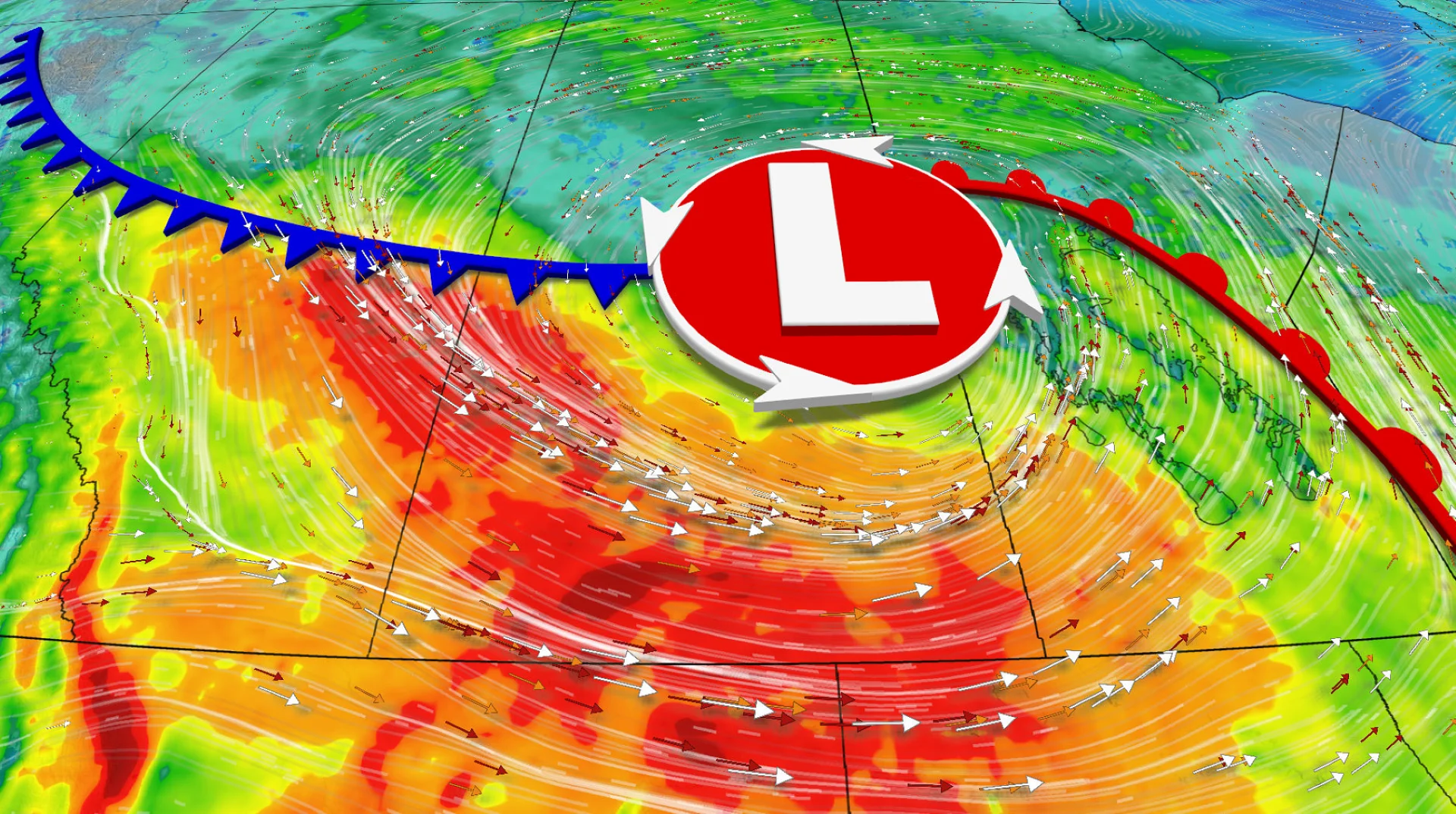
An incoming Prairies system could be powerful enough to set a record for low pressure for May. So, brace for some intense wind gusts.
Parts of the region will see a rough Thursday, with potentially damaging winds in store. Gusts could reach 80-100+ km/h in parts of Alberta and Saskatchewan. Winds will pick up late-day Thursday in Manitoba.
DON'T MISS: Summer Sneak Peek: El Niño may split Canada’s summer in two
Residents are reminded to secure loose outdoor objects and prepare in case of any power outages.
As well, with a looming cooldown, that means snow will return with single-digit, daytime highs in time for the long weekend.
Weather Highlights:
Warmth, instability on Wednesday drives up chance of thunderstorms along the Alberta foothills, extreme southern areas
Intense wind gusts of 60-100+km/h possible Thursday for the Prairies
Blustery winds of 50-70+ km/h continue Friday for parts of Saskatchewan, Manitoba
Cooldown brings chance of snow for some, with chill continuing on the long weekend
Wednesday: Storm risk for Alberta, winds pick up in the evening
Showers and thunderstorms will spread across Alberta through Wednesday.

SEE ALSO: Canada's May long weekend hopes hang on looming pattern change
The foothills and southern Alberta have the greatest chance of seeing thunderstorms.
Breezy winds of 40-60+ km/h are forecast for southern Alberta and Saskatchewan through the evening and overnight.
Thursday: Unusually strong storm for May, winds intensify
Based on forecast models, the low-pressure system is forecast to strengthen to a possible, record-low pressure for the month of May.

If the low deepens below 980 millibars as it sweeps across the central Prairies, it will be the deepest, low-pressure system for the month of May.
Impacts that come along with this type of low pressure system are strong winds due to a tight pressure gradient, and can also indirectly increase precipitation totals.

Showers and narrow bands or pockets of moderate to heavy rain will spread across Saskatchewan and Manitoba through Thursday as the low strengthens over Saskatchewan. Locally moderate rain will continue across northern Alberta.
30-60 mm of rain is possible across northern Alberta, heightening the flooding threat.

Strong, northwesterly winds will blow across Alberta and Saskatchewan with local gusts of 80-100+ km/h. Damage and power outages are possible.
Strong winds will spread into southwestern Manitoba late-day Thursday.
WATCH: Powerful winds headed for the Prairies, how to best prepare
Friday: Intense winds move east, chance of snow for some
Strong wind gusts of 50-70+ km/h are still likely Friday for southern areas of Saskatchewan and Manitoba, and northern sections of the latter through the day.
Through the pre-dawn hours of Friday, cold air will force south, transitioning rain to snow and icy precipitation across far northern Saskatchewan and Manitoba, with snow also possible across northeastern Alberta.

2-5+ cm of snow is forecast across parts of northern Saskatchewan and Manitoba, with locally up to 10 cm.
A near 20-degree temperature contrast across northern and southern Manitoba is expected Friday with near 20 degree-warmth hanging on in the south, and sub-freezing daytime highs in the far north.
Long-range outlook includes cool temperatures and snow for the Rockies
Below-seasonal temperatures will be the general trend for the long weekend across the Prairies, with single-digit, daytime highs possible for some.
Snow is likely for the Rockies and chances for showers on and off throughout the weekend, with an unsettled, cool pattern generally across the region.
WATCH BELOW: Whisky made in Alberta has special qualities thanks to the weather
Stay tuned to The Weather Network as we continue to update the forecast for Alberta.