Night-shining clouds over Calgary: What's the cause of this spectacular sight?

The origin of these eerie clouds is literally out of this world!
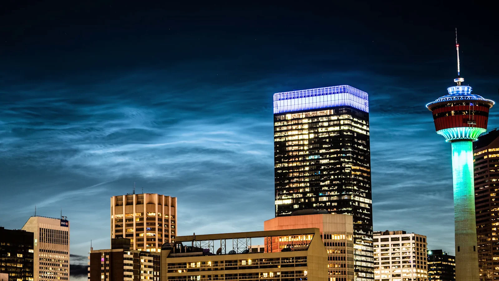
Weather Network Calgary video journalist and storm chaser Kyle Brittain captured something amazing Thursday evening, high above the city of Calgary, AB. The entire sky was filled with noctilucent, or 'night-shining', clouds. So, what causes this spectacular sight?
The basis for all clouds we see in the sky is the same simple process: water vapour collects or freezes onto tiny particles in the air (called 'cloud condensation nuclei'), producing water droplets and/or ice crystals. The wide variety of cloud types we see are a result of the specific circumstances - the amount of water vapour present, the abundance (and sometimes the type) of particles in the air, the temperature of the air and how it changes with time and altitude, the motion of the wind, and even the geographic terrain of the region.
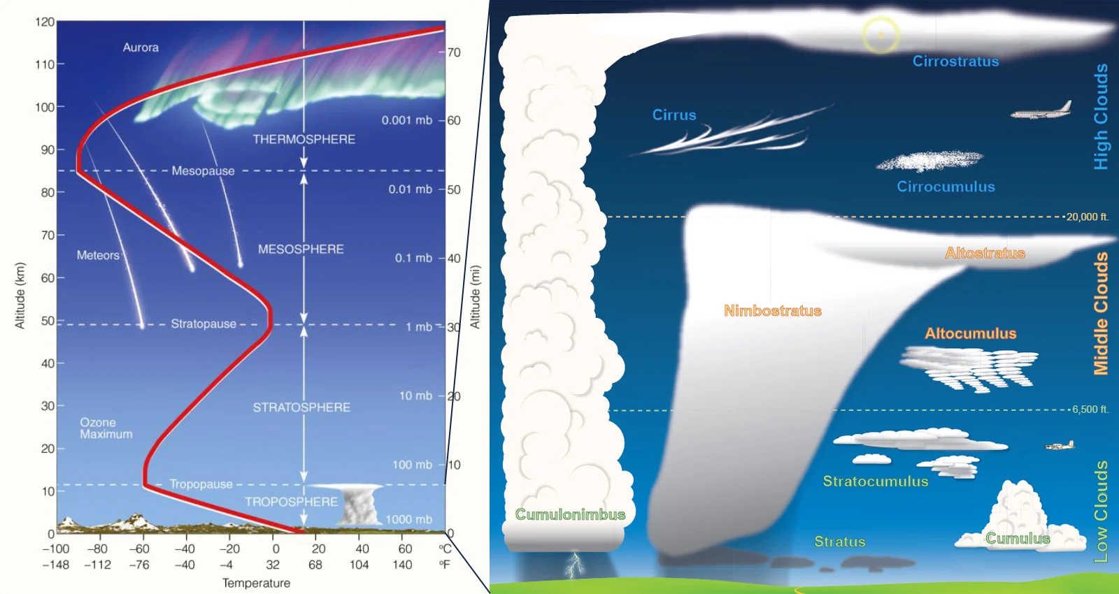
The temperature profile of Earth's atmosphere (left) with significant features, and the various types of clouds that occur in the lowest 12 kilometres (right). Credit: NOAA/Weather.gov
All of the cloud types we see, on a routine day-to-day basis, appear in the troposphere - the lowest 12 kilometres or so of the atmosphere. This is where water vapour is at its highest concentration. It is also where the vast majority of atmospheric particles are (dust, sand, sea salt, pollen, smoke, ash, etc.). Plus, temperatures generally fall, the higher you go above the ground, which results in warm, humid air rising, cooling and causing clouds to condense. Thus, the troposphere is where nearly all of Earth's weather occurs. Above the troposphere, water vapour and particles tend to be more scarce, though, and conditions aren't typically suitable for producing clouds of any type.
Something weird happens at around 80 kilometres above the ground, though.
At an altitude bordering on the edge of space, where water vapour and particles are extremely scarce, vibrant shining clouds can suddenly appear in the sky, just after sunset or just before sunrise.

These noctilucent clouds appeared over Calgary, AB, in the evening on July 2, 2020. Credit: Kyle Brittain
Officially known as noctilucent, which is Latin for 'night-shining', these clouds occur only in the coldest conditions, because in the thin mesospheric air, ice crystals only form below -120°C. Thus, in the northern hemisphere, we see them in polar regions during summer, where and when the mesosphere is at its coldest.
The exact timing of when you can see these thin, eerily glowing clouds is also very specific. They are only visible when the Sun is just below the horizon when sunlight can reflect off the bottom of the clouds, and the sky is dark enough to provide some contrast to the clouds' brightness.
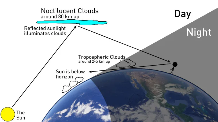
This diagram shows how evening noctilucent clouds are spotted. Credit: Scott Sutherland
OUT OF THIS WORLD
We've known about noctilucent clouds (NLCs) for nearly 135 years, but their likely origin was only figured out fairly recently.
They were first spotted in the days following the August 1885 eruption of the Krakatoa volcano in Indonesia. Their origin was a mystery for a long time afterwards, though. First thought to have been caused by ash from Krakatoa, it was only in the last 10 years, with the launch of certain satellites into orbit, that scientists were able to pin down their source.
The particles in the mesosphere that act as condensation nuclei for NLCs may originate from space!
"We've detected bits of 'meteor smoke' embedded in noctilucent clouds," James Russell of Hampton University, who is the principal investigator of the Aeronomy of Ice in the Mesosphere (AIM) mission, told NASA. "This discovery supports the theory that meteor dust is the nucleating agent around which NLCs form."
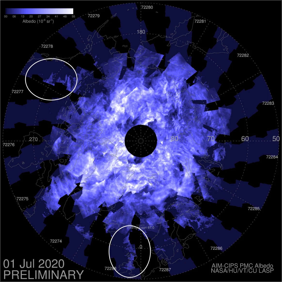
Noctilucent clouds as seen over the northern hemisphere from space by the AIM satellite. Two regions where they have spread much farther south than usual have been circled by the author. Credit: NASA
According to NASA, every day, Earth sweeps up more than 100 tons of dust and sand-sized particles as the planet travels in its orbit around the Sun. The finest grains of this space dust are small enough to act as cloud condensation nuclei for the water vapour present. As are the smoke particles produced by meteors from the larger, faster-moving bits.
When it comes to where the water vapour in the mesosphere is coming from, there are a few potential sources. Some of it likely comes naturally from lower down in the atmosphere. Some is known to come from rocket exhaust during space launches. Micrometeoroids themselves are known to contain water, and some of the material swept up by Earth includes ice crystals. So, space could be, at least partially, the source of both components of these clouds.
THEY ARE SPREADING
There's one other potential source of water vapour that scientists have identified. This one may explain why we are seeing more NLC displays in recent years, and why they are being spotted farther from the poles.
Until recently, NLCs have been pretty much restricted to a range between 50° and 70° latitude (or, from just north of the Canada - U.S. border in western Canada to the middle of Baffin Island). Over that span, you're far enough north so that ice crystals can form in the upper atmosphere, while far enough south that you actually get twilight, as opposed to the Midnight Sun.
In 2019, however, they seemed to be turning up all over the place. In fact, a new 'southern record' for sightings was set in mid-June of last year, when they were spotted near Los Angeles, California. That's nearly 20° latitude farther south than typical.
NLCs were also seemingly more vibrant last year, making the rounds on social media in numerous 'outbreaks' all across Canada, the United States, and Europe.
So why are these, some of Earth's rarest clouds, not as rare as they used to be? As is so often the case, it may be our fault.
A recent study points to the increase in methane in the atmosphere as the main culprit. Researchers from the Leibniz Institute of Atmospheric Physics found that increased methane drove a rise in water vapour in the mesosphere, making it both easier for the clouds to form, and making them brighter and more visible.
"In recent decades it is likely to see one or more NLC per season," said the team, "whereas the probability was only once per several decades before the beginning of industrialization." And they add that, in historic times, the clouds were likely too infrequent and too hard to see to be noticed and categorized.
Their conclusion? The spread of NLCs and their sightings are a "long-term indicator" for climate change.
Sources: NASA Science | NASA | With files from The Weather Network