
Snow-powered Ontario winter storm leaves hefty cleanup in its wake

The first weekend in March certainly came in like a lion in southern Ontario with a potent winter storm hammering the region with significant snowfall and intense wind gusts.
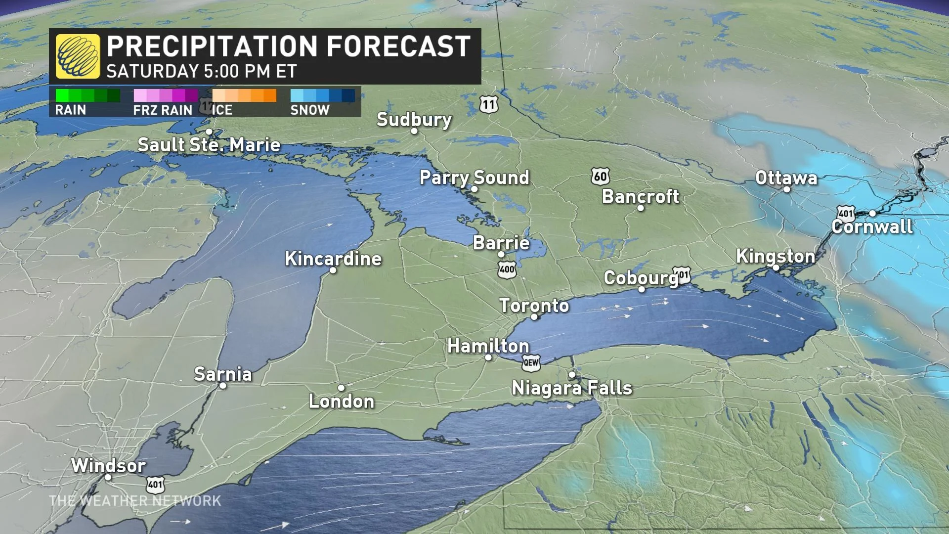
The result was dangerous travel conditions, localized power outages, and flight delays and cancellations as high winds and heavy snowfall blanketed the region. Poor conditions will hang on into Saturday afternoon for eastern sections.
Visit our Complete Guide to Spring 2023 for an in-depth look at the Spring Forecast, tips to plan for it and much more!
Conditions improve Saturday afternoon
For most of the south, the heaviest snowfall and gustiest winds lasted through the early-morning hours on Saturday. During the height of the storm, snowfall rates of over 5 centimetres per hour were forecast, along with wind gusts of 60-70+ km/h. Thundersnow was also reported in many locales experiencing the most intense snowfall rates.
DON'T MISS: PHOTOS: Winter storm illuminates skies and buries roads in Ontario
While snow has since exited most of southern Ontario, it will linger in eastern Ontario into the early afternoon, with an additional 10 cm forecast by the time it departs.
WATCH: 'The night of thundersnow'; Winter and spring clash over Ontario
RELATED: How the City of Toronto is preparing for the big storm
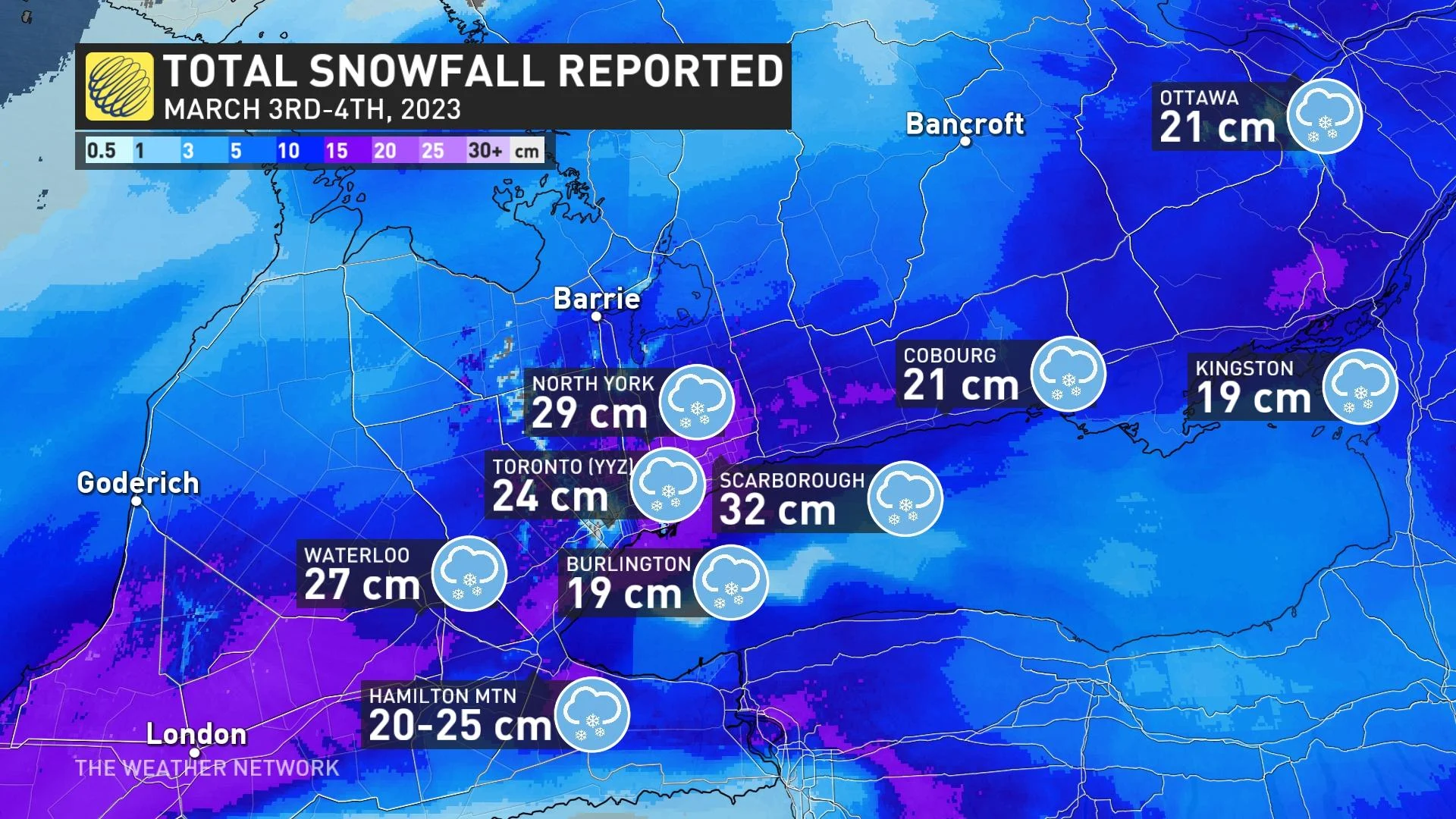
As of early Saturday afternoon, hefty snowfall totals have been reported in several locales including 32 cm in Scarborough, 31 cm at Trenton airport, 30 cm in Vaughan and Newmarket, 29 cm in North York, 27 cm in Waterloo and 24 cm at Toronto's Pearson International Airport.
Making a bad situation worse, temperatures hovering near the freezing mark made this a heavy, wet snowfall.
Gusty winds and the weight of this wet snow on trees and power lines brought localized power outages throughout the area, with Hydro One reporting more than 1,500 as of Saturday afternoon. Remain mindful of trees and tree branches that could fall during the storm.
BE PREPARED: Staying safe during a power outage
Shovelling up to 30 cm of snow is also a chore on its own, but the sheer weight of the snow will increase the challenge of the post-storm cleanup. Pay extra mind to the physical stress of shovelling heavy snow, taking care to stretch beforehand, shovel with safety in mind, and stop for frequent breaks.
Beyond this storm, temperatures will warm up a touch heading into the first weekend of March. Daytime highs approaching the mid-single digits will aid with cleanup efforts, though black ice will be a concern each night as lows drop below freezing.
WATCH: Thundersnow light show comes to Ontario, see it here
Prime ski conditions for March break
Below-seasonal temperatures will return for the second half of next week and through the following week, which is March break for most schools.
At this point, we don't expect frigid weather, but not very spring-like either, with temperatures a few degrees colder than seasonal.
Southern Ontario ski areas should be in great shape for March break.
Thumbnail courtesy of Jia Liu, taken in Mississauga, Ont.
Stay tuned to The Weather Network for the latest on this major storm hitting southern Ontario.