New laser mapping shows dozens of sinkholes near Trans-Canada Highway
Cumberland County officials want the Nova Scotia government to check for sinkholes under the Trans-Canada Highway near the town of Oxford, N.S.
That's after laser mapping showed the area is filled with dozens of large sinkholes in a wide band that crosses the highway between Oxford and Springhill.
"Could what happened at the Lions park … a cover-collapse sinkhole, happen on the Trans-Canada Highway?" said Rachel Jones, CAO of the Town of Oxford.
"That's the question. I don't know if that can happen. It's a concern."
NEW SINKHOLE RISKS A MYSTERY
The issue of sinkholes in Cumberland County roared into the headlines with the collapse of a section of the Lions Club park in Oxford last August.
Extensive seismic and electrical resistivity testing on the property led the Oxford and District Lions Club to permanently close the site because of areas of instability detected underground.
The risk posed over the wider geological area — made up of gypsum, salt, gravel and sandstone — remains a mystery.
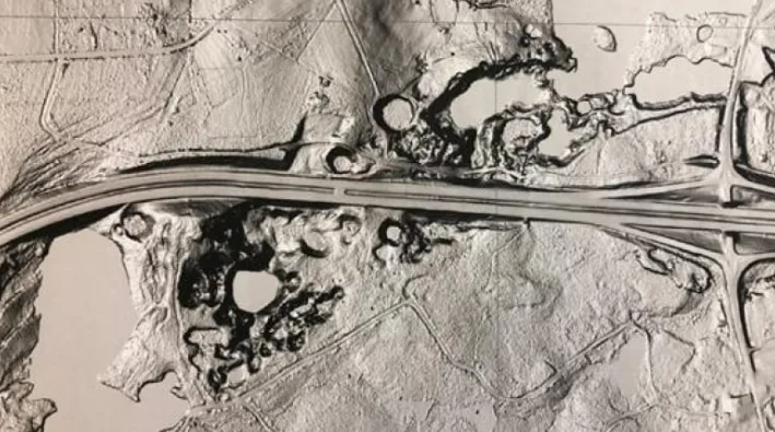
Detailed LIDAR images, which use lasers to map the surface of the landscape, show a band of sinkholes over 100 metres wide stretching several kilometres from Oxford to Springhill and back again.
LIDAR images show the main Highway 104 interchange in Oxford, N.S., and a band of sinkholes along the Trans-Canada Highway. (Province of Nova Scotia)
Of particular concern is land under Highway 104, a section of the Trans-Canada Highway connecting New Brunswick and Nova Scotia.
"I'm of two thoughts," said Mike Johnson, regional emergency management co-ordinator for Cumberland County.
"One is that for the last 40 years we've pounded tons and tons of traffic over that area of the Trans-Canada Highway and then very little has come of it," he said.
"On the other hand … hundred-year-old trees were sitting in a small spot on the Lions Club grounds, that sat there for 100 years, and then all of a sudden fell into a hole," he said.
PERSISTENT POTHOLE
Jones points to the pavement on the westbound lanes of the Trans-Canada Highway, about 500 metres past the Oxford exit.
There's a pothole about a metre wide that's been repeatedly filled and patched.
About seven metres away in the ditch, Jones points to a section of stone retaining wall that has settled by about 15 centimetres.
Another 20 metres behind that, hidden in the trees, is a sinkhole pond surrounded by steep forested hills.
The LIDAR map shows these features are part of a line of sinkholes leading back to the Lions Club property.
Rachel Jones is CAO of the Town of Oxford. (Robert Short/CBC) Jones said the town began examining this section of highway because aerial photographs from the 1930s, taken before the roadway was built, show a water-filled sinkhole where the Trans-Canada now runs.
"If you line up the map, the LIDAR map … there is an area that looks like it's in the same location as this depression in the highway in the travelling lane," she said.
Jones recalls seeing the old photographs and LIDAR images together for the first time.
"Holy cow. I mean, I was just, I was flabbergasted to see the old imagery from the 1930s overlaid with today's LIDAR mapping," she said.
"It blows my mind, really, to say that that was there and they built a highway over it."
Johnson and Jones say the town approached multiple provincial departments about expanding the testing area to include areas around the Trans-Canada and Highway 321, Oxford's main street, but there was no interest.
"It might be absolutely nothing. And if that's the case, fine. But I think we should make an attempt to find out what the case is," Johnson said.
A pothole in the westbound lanes of the Trans-Canada Highway has been repeatedly patched and filled, says CAO Rachel Jones (Robert Short/CBC) Johnson said he's asked Nova Scotia Power, along with fire and ambulance services to prepare plans in case roads were damaged by new sinkholes.
But without a technical study, there's no way to quantify the risks in the coming years.
"That's the real question. How much risk is there? How much probability is there?" he said.
VIDEO: FLORIDA SINKHOLE SWALLOWS THREE TRUCKS
MINISTER POINTS TO MONITORING
On Thursday, Nova Scotia Natural Resources Minister Lloyd Hines said road crews are now checking conditions daily on the Trans-Canada Highway near Oxford, looking for sinkhole activity.
They are also taking a closer look at Highway 321, which runs through the heart of the community.
"We're watching that very closely and are gathering data to see if there's any particular action that we need to take there," he said.
'I DON'T WANT TO PUT FEAR INTO PEOPLE'
Jones said she doesn't want to alarm the public unnecessarily about the stability of the Trans-Canada Highway.
But after the collapse at the Lions Club park, she thinks the travelling public deserves definitive answers.
"Well I think it's fairly serious," she said.
"I don't want to put fear into people, you know. People have been travelling [the highway] for the past year. There hasn't been significant change. But the fact is that it still remains there. And the hole needs patching.… so something's happening that causes it."
This article was written for the CBC by Jack Juilan.


