Active AlertsSand Ridge, TX
For your protection move to an interior room on the lowest floor of abuilding.Torrential rainfall is occurring with these storms, and may lead toflash flooding. Do not drive your vehicle through flooded roadways.
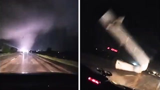
SVRHGXThe National Weather Service in League City has issued a* Severe Thunderstorm Warning for...West central Trinity County in southeastern Texas...Northeastern Grimes County in southeastern Texas...Northwestern Montgomery County in southeastern Texas...Southwestern Houston County in southeastern Texas...Eastern Madison County in southeastern Texas...Central Walker County in southeastern Texas...* Until midnight CDT.* At 1121 PM CDT, severe thunderstorms were located along a lineextending from 8 miles east of Bedias to 15 miles northwest ofHuntsville State Park to Huntsville, moving northeast at 30 mph.HAZARD...Quarter size hail.SOURCE...Radar indicated.IMPACT...Damage to vehicles is expected.* Locations impacted include...Huntsville, Trinity, and Crabbs Prairie.
The National Weather Service has issued Severe Thunderstorm Watch173 in effect until 2 AM CDT Thursday for the following areasIn Texas this watch includes 14 countiesIn southeast TexasAustin Brazos BurlesonColorado Grimes HoustonMadison Montgomery PolkSan Jacinto Trinity WalkerWaller WashingtonThis includes the cities of Bellville, Brenham, Brookshire,Bryan, Caldwell, Coldspring, College Station, Columbus, Conroe,Corrigan, Crockett, Eagle Lake, Groveton, Hempstead, Huntsville,Livingston, Madisonville, Navasota, Prairie View, Sealy,Shepherd, Somerville, The Woodlands, Trinity, Waller, and Weimar.
You should monitor later forecasts and be alert for possible FloodWarnings. Those living in areas prone to flooding should be preparedto take action should flooding develop.
* WHAT...Flooding caused by excessive rainfall continues to bepossible.* WHERE...A portion of southeast Texas, including the followingareas, Austin, Brazos, Burleson, Coastal Harris, Colorado, Grimes,Houston, Inland Harris, Madison, Montgomery, Northern Liberty,Polk, San Jacinto, Southern Liberty, Trinity, Walker, Waller andWashington.* WHEN...Through Thursday evening.* IMPACTS...Excessive runoff may result in flooding of rivers,creeks, streams, and other low-lying and flood-prone locations.* ADDITIONAL DETAILS...- Another round of heavy rainfall and thunderstorms is begin todevelop over Southeast and Central Texas tonight. Grounds arevery saturated, so any additional rainfall will be slow todrain. This can more easily lead to street flooding andadditional rises on area rivers, creeks and streams.Widespread rainfall totals of 2 to 5 inches can be expectednorth of I-10. Isolated higher amounts will be possible.- http://www.weather.gov/safety/flood
Do not drive cars through flooded areas.Caution is urged when walking near riverbanks.Turn around, don't drown when encountering flooded roads. Most flooddeaths occur in vehicles.Caution is urged when walking near riverbanks.For more hydrologic information, copy and paste the following websiteaddress into your favorite web browser URL bar:water.weather.gov/ahps2/index.php?wfo=shvThe next statement will be issued Thursday evening at 930 PM CDT.
...The Flood Warning is extended for the following rivers in Texas...Neches River At Rockland affecting Tyler, Jasper, Polk andAngelina Counties....The Flood Warning continues for the following rivers in Texas...Neches River Near Diboll affecting Houston, Polk, Trinity, Tylerand Angelina Counties.Neches River Near Alto affecting Trinity, Houston, Cherokee andAnderson Counties.Neches River Near Neches affecting Houston, Cherokee and AndersonCounties.For the Neches River...including Lake Palestine, Neches, Alto,Diboll, Rockland...Minor flooding is forecast.* WHAT...Minor flooding is occurring and minor flooding is forecast.* WHERE...Neches River near Alto.* WHEN...Until further notice.* IMPACTS...At 18.0 feet, Expect moderate to severe flooding of theheavily wooded floodplain. Boat ramps and picnic areas will becompletely inundated.* ADDITIONAL DETAILS...- At 9:15 PM CDT Wednesday the stage was 17.3 feet.- Bankfull stage is 16.0 feet.- Recent Activity...The maximum river stage in the 24 hoursending at 9:15 PM CDT Wednesday was 17.5 feet.- Forecast...The river is expected to fall to 16.4 feet Mondayevening.- Flood stage is 16.0 feet.- Flood History...This crest compares to a previous crest of17.3 feet on 05/23/1954.- http://www.weather.gov/safety/flood
Do not drive cars through flooded areas.Caution is urged when walking near riverbanks.Turn around, don't drown when encountering flooded roads. Most flooddeaths occur in vehicles.Caution is urged when walking near riverbanks.For more hydrologic information, copy and paste the following websiteaddress into your favorite web browser URL bar:water.weather.gov/ahps2/index.php?wfo=shvThe next statement will be issued Thursday evening at 930 PM CDT.
...The Flood Warning is extended for the following rivers in Texas...Neches River At Rockland affecting Tyler, Jasper, Polk andAngelina Counties....The Flood Warning continues for the following rivers in Texas...Neches River Near Diboll affecting Houston, Polk, Trinity, Tylerand Angelina Counties.Neches River Near Alto affecting Trinity, Houston, Cherokee andAnderson Counties.Neches River Near Neches affecting Houston, Cherokee and AndersonCounties.For the Neches River...including Lake Palestine, Neches, Alto,Diboll, Rockland...Minor flooding is forecast.* WHAT...Minor flooding is occurring and minor flooding is forecast.* WHERE...Neches River near Diboll.* WHEN...Until further notice.* IMPACTS...At 14.0 feet, Minor lowland flooding of boat ramps,paths, and trails. Move livestock and equipment to higher ground.* ADDITIONAL DETAILS...- At 8:15 PM CDT Wednesday the stage was 14.1 feet.- Bankfull stage is 12.0 feet.- Recent Activity...The maximum river stage in the 24 hoursending at 8:15 PM CDT Wednesday was 14.7 feet.- Forecast...The river is expected to rise to a crest of 14.0feet Friday morning.- Flood stage is 12.0 feet.- Flood History...This crest compares to a previous crest of14.1 feet on 02/12/1948.- http://www.weather.gov/safety/flood
Do not drive cars through flooded areas.Caution is urged when walking near riverbanks.Turn around, don't drown when encountering flooded roads. Most flooddeaths occur in vehicles.Caution is urged when walking near riverbanks.For more hydrologic information, copy and paste the following websiteaddress into your favorite web browser URL bar:water.weather.gov/ahps2/index.php?wfo=shvThe next statement will be issued Thursday evening at 930 PM CDT.
...The Flood Warning is extended for the following rivers in Texas...Neches River At Rockland affecting Tyler, Jasper, Polk andAngelina Counties....The Flood Warning continues for the following rivers in Texas...Neches River Near Diboll affecting Houston, Polk, Trinity, Tylerand Angelina Counties.Neches River Near Alto affecting Trinity, Houston, Cherokee andAnderson Counties.Neches River Near Neches affecting Houston, Cherokee and AndersonCounties.For the Neches River...including Lake Palestine, Neches, Alto,Diboll, Rockland...Minor flooding is forecast.* WHAT...Minor flooding is occurring and minor flooding is forecast.* WHERE...Neches River near Neches.* WHEN...Until further notice.* IMPACTS...At 14.0 feet, Minor lowland flooding. Move livestockand equipment to higher ground away from the river.* ADDITIONAL DETAILS...- At 8:30 PM CDT Wednesday the stage was 14.1 feet.- Bankfull stage is 12.0 feet.- Recent Activity...The maximum river stage in the 24 hoursending at 8:30 PM CDT Wednesday was 14.2 feet.- Forecast...The river is expected to fall to 12.4 feet Mondayevening.- Flood stage is 12.0 feet.- Flood History...This crest compares to a previous crest of14.0 feet on 12/28/2013.- http://www.weather.gov/safety/flood