Active AlertsFannett, TX
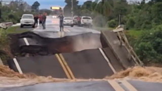
...The Flood Warning is extended for the following rivers inLouisiana...Texas...Calcasieu River Near Salt Water BarrierSabine River Near Burkeville...The Flood Warning continues for the following rivers in Texas...Louisiana...Village Creek Near KountzePine Island Bayou Near Sour LakeCalcasieu River Near GlenmoraCalcasieu River near White Oak ParkCalcasieu River Near OberlinSabine River Near Bon WierSabine River Near DeweyvilleNeches River Near EvadaleNeches River Near Town BluffNeches River at Neches River Saltwater BarrierAdditional information is available at www.weather.gov.The next statement will be issued as needed. Wednesday evening at900 PM CDT.* WHAT...Major flooding is occurring and major flooding is forecast.* WHERE...Neches River at Neches River Saltwater Barrier.* WHEN...Until further notice.* IMPACTS...At 10.5 feet, The NOAA weather radio is subject to goingoff the air.* ADDITIONAL DETAILS...- At 8:15 PM CDT Tuesday the stage was 10.3 feet.- Recent Activity...The maximum river stage in the 24 hoursending at 8:15 PM CDT Tuesday was 10.7 feet.- Forecast...The river is expected to fall to 8.1 feet Sundayevening.- Flood stage is 4.0 feet.- http://www.weather.gov/safety/flood