Active AlertsCooper, TX
Turn around, don't drown when encountering flooded roads. Most flooddeaths occur in vehicles.Be especially cautious at night when it is harder to recognize thedangers of flooding.
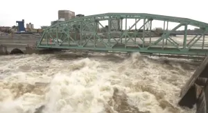
Flooding continues across portions of Southeast Texas in the wakeof rounds of heavy rain and thunderstorms. Though heavy rain hasended for now, flooding is still ongoing while waters graduallydrain. Please continue to use caution while traveling - especiallyat night - and heed the advice of local officials. If you encounterflooded roads while traveling, turn around and find another way.* WHAT...Flooding caused by excessive rainfall is occurring.* WHERE...A portion of southeast Texas, including the followingcounties, Grimes, Houston, Liberty, Madison, Montgomery, Polk, SanJacinto, Trinity and Walker.* WHEN...Until 800 AM CDT Friday.* IMPACTS...Flooding of rivers, creeks, streams, and other low-lyingand flood-prone locations is imminent or occurring. Numerous roadsremain closed due to flooding. Low-water crossings are inundatedwith water and may not be passable. It will take several hours forall the water from these storms to work through local drainagesystems in urban areas. Local media have reported water rescues.* ADDITIONAL DETAILS...- At 500 PM CDT, Flooding has been reported in locations acrossthe warned area.- Some locations that will experience flooding include...Conroe, Huntsville, Cleveland, Willis, Livingston, Shepherd,Panorama Village, Onalaska, Cut And Shoot, Groveton, NewWaverly, Coldspring, Point Blank, Montgomery, Riverside,Goodrich, North Cleveland, Huntsville State Park, LakeLivingston State Park and West Livingston.- http://www.weather.gov/safety/flood
You should monitor later forecasts and be alert for possible FloodWarnings. Those living in areas prone to flooding should be preparedto take action should flooding develop.
* WHAT...Flooding caused by excessive rainfall continues to bepossible.* WHERE...A portion of southeast Texas, including the followingareas, Brazos, Burleson, Coastal Harris, Grimes, Houston, InlandHarris, Madison, Montgomery, Northern Liberty, Polk, San Jacinto,Southern Liberty, Trinity, Walker, Waller and Washington.* WHEN...Through this evening.* IMPACTS...Excessive runoff may result in flooding of rivers,creeks, streams, and other low-lying and flood-prone locations.Flooding may occur in poor drainage and urban areas. Low-watercrossings may be flooded.* ADDITIONAL DETAILS...- Model guidance suggests potential for heavier rains in thewatch area early today through this evening. Any furtherrainfall would at best slow the recession of existingfloodwaters, and at worst would aggravate this flooding.Saturated soils will result in a greater risk of flashflooding, even at rain rates that typically do not causeproblems in this area. 1-2 inches of new rainfall arepossible with isolated totals of up to 3-4 inches.- http://www.weather.gov/safety/flood
Do not drive cars through flooded areas.Caution is urged when walking near riverbanks.Turn around, don't drown when encountering flooded roads. Most flooddeaths occur in vehicles.Caution is urged when walking near riverbanks.For more hydrologic information, copy and paste the following websiteaddress into your favorite web browser URL bar:water.weather.gov/ahps2/index.php?wfo=shvThe next statement will be issued Friday evening at 945 PM CDT.
...The Flood Warning continues for the following rivers in Texas...Neches River At Rockland affecting Tyler, Angelina, Polk andJasper Counties.Neches River Near Diboll affecting Trinity, Tyler, Houston, Polkand Angelina Counties.Neches River Near Alto affecting Anderson, Houston, Cherokee andTrinity Counties.Neches River Near Neches affecting Anderson, Houston and CherokeeCounties.For the Neches River...including Lake Palestine, Neches, Alto,Diboll, Rockland...Moderate flooding is forecast.* WHAT...Minor flooding is occurring and minor flooding is forecast.* WHERE...Neches River near Neches.* WHEN...Until further notice.* IMPACTS...At 14.0 feet, Minor lowland flooding. Move livestockand equipment to higher ground away from the river.* ADDITIONAL DETAILS...- At 8:30 PM CDT Thursday the stage was 14.1 feet.- Bankfull stage is 12.0 feet.- Recent Activity...The maximum river stage in the 24 hoursending at 8:30 PM CDT Thursday was 14.1 feet.- Forecast...The river is expected to rise to a crest of 14.2feet early Monday afternoon.- Flood stage is 12.0 feet.- Flood History...This crest compares to a previous crest of14.4 feet on 06/06/2017.- http://www.weather.gov/safety/flood
Do not drive cars through flooded areas.Caution is urged when walking near riverbanks.Turn around, don't drown when encountering flooded roads. Most flooddeaths occur in vehicles.Caution is urged when walking near riverbanks.For more hydrologic information, copy and paste the following websiteaddress into your favorite web browser URL bar:water.weather.gov/ahps2/index.php?wfo=shvThe next statement will be issued Friday evening at 945 PM CDT.
...The Flood Warning continues for the following rivers in Texas...Neches River At Rockland affecting Tyler, Angelina, Polk andJasper Counties.Neches River Near Diboll affecting Trinity, Tyler, Houston, Polkand Angelina Counties.Neches River Near Alto affecting Anderson, Houston, Cherokee andTrinity Counties.Neches River Near Neches affecting Anderson, Houston and CherokeeCounties.For the Neches River...including Lake Palestine, Neches, Alto,Diboll, Rockland...Moderate flooding is forecast.* WHAT...Minor flooding is occurring and minor flooding is forecast.* WHERE...Neches River near Diboll.* WHEN...Until further notice.* IMPACTS...At 16.0 feet, Lowland flooding will slowly decrease forthe next several days.* ADDITIONAL DETAILS...- At 9:15 PM CDT Thursday the stage was 15.2 feet.- Bankfull stage is 12.0 feet.- Recent Activity...The maximum river stage in the 24 hoursending at 9:15 PM CDT Thursday was 15.2 feet.- Forecast...The river is expected to rise to a crest of 16.1feet early Saturday morning.- Flood stage is 12.0 feet.- Flood History...This crest compares to a previous crest of16.0 feet on 01/24/2019.- http://www.weather.gov/safety/flood
Do not drive cars through flooded areas.Caution is urged when walking near riverbanks.Turn around, don't drown when encountering flooded roads. Most flooddeaths occur in vehicles.Caution is urged when walking near riverbanks.For more hydrologic information, copy and paste the following websiteaddress into your favorite web browser URL bar:water.weather.gov/ahps2/index.php?wfo=shvThe next statement will be issued Friday evening at 945 PM CDT.
...The Flood Warning continues for the following rivers in Texas...Neches River At Rockland affecting Tyler, Angelina, Polk andJasper Counties.Neches River Near Diboll affecting Trinity, Tyler, Houston, Polkand Angelina Counties.Neches River Near Alto affecting Anderson, Houston, Cherokee andTrinity Counties.Neches River Near Neches affecting Anderson, Houston and CherokeeCounties.For the Neches River...including Lake Palestine, Neches, Alto,Diboll, Rockland...Moderate flooding is forecast.* WHAT...Minor flooding is occurring and moderate flooding isforecast.* WHERE...Neches River near Alto.* WHEN...Until further notice.* IMPACTS...At 18.0 feet, Expect moderate to severe flooding of theheavily wooded floodplain. Boat ramps and picnic areas will becompletely inundated.* ADDITIONAL DETAILS...- At 9:15 PM CDT Thursday the stage was 18.0 feet.- Bankfull stage is 16.0 feet.- Recent Activity...The maximum river stage in the 24 hoursending at 9:15 PM CDT Thursday was 18.0 feet.- Forecast...The river is expected to rise to a crest of 18.3feet early Saturday morning.- Flood stage is 16.0 feet.- Flood History...This crest compares to a previous crest of18.3 feet on 04/24/2020.- http://www.weather.gov/safety/flood