Active AlertsCollinsville, OK
If outdoors, consider seeking shelter inside a building.
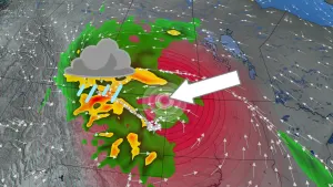
At 553 AM CDT, Doppler radar indicated a strong thunderstorm 3 mileseast of Owasso, moving northwest at 10 mph.HAZARD...Nickel size hail.SOURCE...Radar indicated.IMPACT...Minor hail damage to vegetation is possible.Locations in or near the path include...Tulsa... Claremore...Owasso... Skiatook...Catoosa... Collinsville...Verdigris... Turley...Tulsa International Airport...This includes Interstate 44 between mile markers 236 and 242.
Turn around, don't drown when encountering flooded roads. Most flooddeaths occur in vehicles.
* WHAT...Flooding caused by excessive rainfall is expected.* WHERE...A portion of northeast Oklahoma, including the followingcounties, Creek, Osage, Pawnee, Rogers, Tulsa and Washington OK.* WHEN...Until 900 AM CDT.* IMPACTS...Minor flooding in low-lying and poor drainage areas.Ponding of water in urban or other areas is occurring or isimminent.* ADDITIONAL DETAILS...- At 550 AM CDT, Doppler radar indicated heavy rain due tothunderstorms. Minor flooding is ongoing or expected to beginshortly in the advisory area.- Additional rainfall amounts of 1 to 2 inches are expectedover the area. This additional rain will result in minorflooding.- Some locations that will experience flooding include...Tulsa... Broken Arrow...Sand Springs... Claremore...Owasso... Bixby...Sapulpa... Jenks...Glenpool... Skiatook...Catoosa... Collinsville...Hominy... Cleveland...Mannford... Kiefer...Fairfax... Barnsdall...Sperry... Oologah...- http://www.weather.gov/safety/flood