Active AlertsSchoer Place, NV
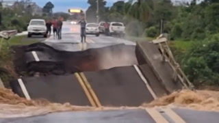
If you encounter a flooded roadway, turn around and find analternative route.Caution is urged when walking near riverbanks.Additional information is available at www.weather.gov.The next statement will be issued late tonight at 500 AM PDT.
...The Flood Advisory continues for the following rivers in Nevada...Owyhee River near Mountain City affecting Elko County.For the Owyhee River...including Wildhorse Dam, Wildhorse, MountainCity...elevated river levels are forecast.* WHAT...Flooding caused by snowmelt is possible.* WHERE...Owyhee River near Mountain City.* WHEN...Until further notice.* IMPACTS...At 8.0 feet, Minor flooding along the river channel.* ADDITIONAL DETAILS...- At 11:25 AM PDT Tuesday the stage was 6.7 feet.- Bankfull stage is 7.0 feet.- Forecast...The river is forecast to continue to range around7.0 feet over the next several days with gradual increasesand decreases in height. As such, it will continue to move inand out of action stage.- Action stage is 7.0 feet.- Flood stage is 8.0 feet.- http://www.weather.gov/safety/flood