Active AlertsBoys Town, NE
You should monitor later forecasts and be alert for possible FloodWarnings. Those living in areas prone to flooding should be preparedto take action should flooding develop.
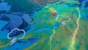
The best chances for heavy rain overnight has been shifting south.As a result, have trimmed a few northern counties off of the watchand added a few counties on the southern edge of the watch.* WHAT...Flooding caused by excessive rainfall continues to bepossible.* WHERE...Portions of Iowa, including the following counties,Harrison, Monona, Pottawattamie and Shelby and Nebraska, includingthe following counties, Burt, Butler, Colfax, Cuming, Dodge,Douglas, Platte, Sarpy, Saunders, Thurston and Washington.* WHEN...Through Tuesday evening.* IMPACTS...Excessive runoff may result in flooding of rivers,creeks, streams, and other low-lying and flood-prone locations.* ADDITIONAL DETAILS...- Multiple rounds of heavy precipitation is expected with anincreasing potential for training thunderstorms to developafter midnight. A second round of heavy rain is expectedTuesday late morning and afternoon. This will bring thethreat for flash flooding and river flooding across portionsof northeast Nebraska, east-central Nebraska, and west-central Iowa.- http://www.weather.gov/safety/flood