Active AlertsRound Spring, MO
You should monitor later forecasts and be prepared to take actionshould Flash Flood Warnings be issued.
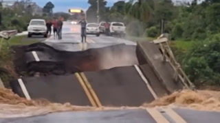
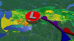
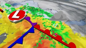
* WHAT...Flash flooding caused by excessive rainfall is possible.* WHERE...Portions of central, east central, south central,southwest, and west central Missouri, including the followingareas, in central Missouri, Benton, Camden, Hickory, Maries,Miller, Morgan and Pulaski. In east central Missouri, Phelps. Insouth central Missouri, Dent, Shannon and Texas. In southwestMissouri, Cedar, Dallas, Laclede, Polk, Webster and Wright. Inwest central Missouri, St. Clair.* WHEN...From 10 AM CDT this morning through this evening.* IMPACTS...Excessive runoff may result in flooding of rivers,creeks, streams, and other low-lying and flood-prone locations.* ADDITIONAL DETAILS...- Repeated thunderstorms with heavy rainfall are possible inthe watch area this morning into this evening. Rainfallamounts of 1 to 3 inches with locally higher amounts of 3 to6 inches are possible. Rainfall over the last 2 weeks hasbeen 2 to 4 times above normal in the watch area, which willincrease the flash flood risk.- http://www.weather.gov/safety/flood