Active Alerts Green Mound Ridge, MO
Turn around, don't drown when encountering flooded roads. Many flooddeaths occur in vehicles.
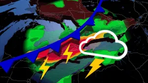
* WHAT...Ongoing flooding will continue today and tonight fromexcessive rainfall over the weekend.* WHERE...Portions of central, east central, south central,southwest, and west central Missouri, including the followingcounties, in central Missouri, Benton, Camden, Hickory andPulaski. In east central Missouri, Phelps. In south centralMissouri, Dent, Howell, Oregon, Shannon and Texas. In southwestMissouri, Barton, Cedar, Christian, Dade, Dallas, Douglas, Greene,Laclede, Ozark, Polk, Webster and Wright. In west centralMissouri, St. Clair and Vernon.* WHEN...Until 800 AM CDT Tuesday.* IMPACTS...Minor flooding in low-lying and poor drainage areas.* ADDITIONAL DETAILS...- At 759 AM CDT, The Department of Transportation reportedflooding from previous heavy rain in the advisory area.- Many low water crossings remain flooded with closed roadswithin the advisory area.- Some locations that will experience flooding include...Fort Leonard Wood, Lebanon, West Plains, Bolivar, Nevada,Marshfield, Waynesville, Mountain Grove, El Dorado Springs,Buffalo, Ava, Mountain View, Strafford, Willow Springs,Houston, Stockton, Hermitage, St. Robert, Licking, Cabool,Seymour, Richland, Fair Grove, Mansfield, Appleton City,Humansville, Osceola, Fordland, Conway, Gainesville, Norwood,Walnut Grove, Lowry City, Pleasant Hope, Hartville, Sheldon,Summersville, Fair Play, Weaubleau and Urbana.- http://www.weather.gov/safety/flood