In honour of Halloween, let's explore some creepy weather phenomena
From clouds that spark UFO sightings to mysterious forms under the ice, Canada's spectacular natural environment has its fair share of spooky scenes. We take a look at the best of Canada's scary weather, below.
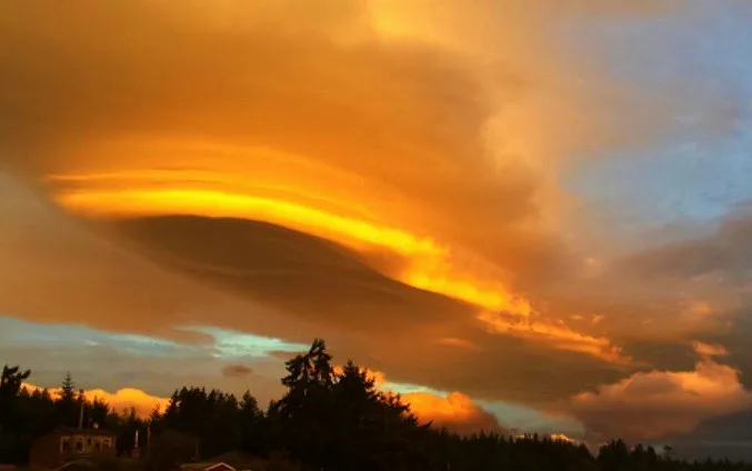
CLOUD OR UFO?
Some of the strangest clouds nature has to offer are frequent visitors for parts of the west. Lenticular clouds, with their distinctive 'flying saucer' shape, form when moist air flows up over an obstruction -- like the mountains that feature prominently in western Canada's topography.
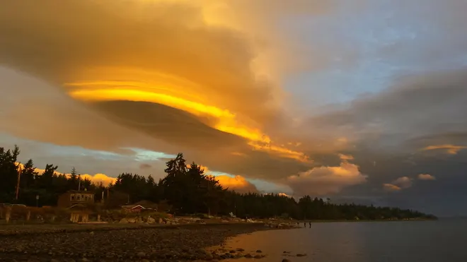
Lenticular clouds over Nile Creek Beach, Bowser, British Columbia. Image courtesy Duane Harding, Sept 4, 2016.
SEE ALSO: Amazing UFO-like cloud hovers over jagged peaks of Patagonia
SPOOKY SEVERE STORM
A bit further east, the big skies of the Prairies are often home to creepy clouds of a different nature. Massive thunderstorm cells form every year over Alberta, Saskatchewan, and Manitoba as the Rockies funnel cloud dry air down to clash with moist, hot air infusions from the U.S. Plains. The result is explosive storms capable of producing massive hail, torrential downpours, and even tornadoes.
The storm featured in the video above, captured on camera by The Weather Network's former Alberta bureau reporter Kyle Brittain, shows how large a single storm cell can be as it blots out the sky above him. Backlighting from the sun also helps to show the texture of the fierce storm in fine detail.
DID SOMEONE TAKE A BITE OUT OF THESE CLOUDS?
While it might look like someone's been snacking on the sky, fallstreak holes, a.k.a. skypunches or hole punch clouds, form thanks to water and ice processes happening at the cloud level.
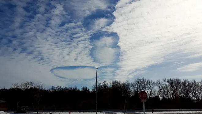
Fallstreak hole clouds hover over Stouffville, Ontario. Image courtesy Tim Gain, Feb 17, 2017.
Fallstreak holes are the result of the rapid freezing of supercooled water droplets. Once ice crystal formation takes over in a part of the cloud, the effect spreads, and neighbouring water droplets evaporate 'eating away' a section of the cloud deck and leaving a hole.
EVEN GHOSTS LIKE TO BUILD SNOWMEN
From tiny snowballs to giant snow tumbleweeds, snow rollers might look like they're getting a ghostly helping hand, but it's a combination of natural factors at work.
When a thin, damp layer of snow falls over a hard-packed or icy layer, it's easy for that surface snow to be scooped up by the wind. If the wind is strong enough to start a clump of wet snow moving, but weak enough not to tear it apart, these self-propelled snowballs can sometimes result. Another unseen force -- gravity -- can also give snow rollers an assist.
STRANGE VISIONS UNDER THE ICE
And finally, this unsettling scene from Halifax looks like a school of mysterious shapes swiftly swimming downstream isn't as supernatural as it seems.
These are actually air bubbles skimming along with the water flowing under the ice. The first half of February 2019 was mild in Halifax, but tumbling temperatures in the second half of the month would have allowed the return of thin ice coatings atop free-flowing streams and creeks, giving rise to shots like these.
WATCH: UFO-like cloud hangs over Niagara, this is what it is
Editor's note: This article was originally published on Oct. 28, 2019.