
Summer off to a fast start in Ontario with extreme heat and humidity

Extreme heat and humidity forecast for Ontario this week, with the warmest temperatures of 2022 expected on Tuesday as daytime highs soar towards the upper 30s for some.
--
Summer arrives Tuesday, with the season getting off to a hot and humid start across Ontario. The week was kick-started by extreme heat and uncomfortable humidity for some, becoming widespread Tuesday. Far-reaching temperatures in the low and mid-30s are expected, with humidex values entering the 40s for some areas, coming close to reaching or surpassing record levels. Tuesday night won't provide any relief from the heat, so it could be an uncomfortable sleep for many, even with proper cooling equipment. More on how hot things will get and where the warmest temperatures will be, below.
THIS WEEK: SOME OF THE WARMEST WEATHER OF THE YEAR ARRIVES WITH THE OFFICIAL START TO SUMMER
Heat warnings are in effect in southern Ontario, with a multi-day event expected to persist into at least Wednesday.
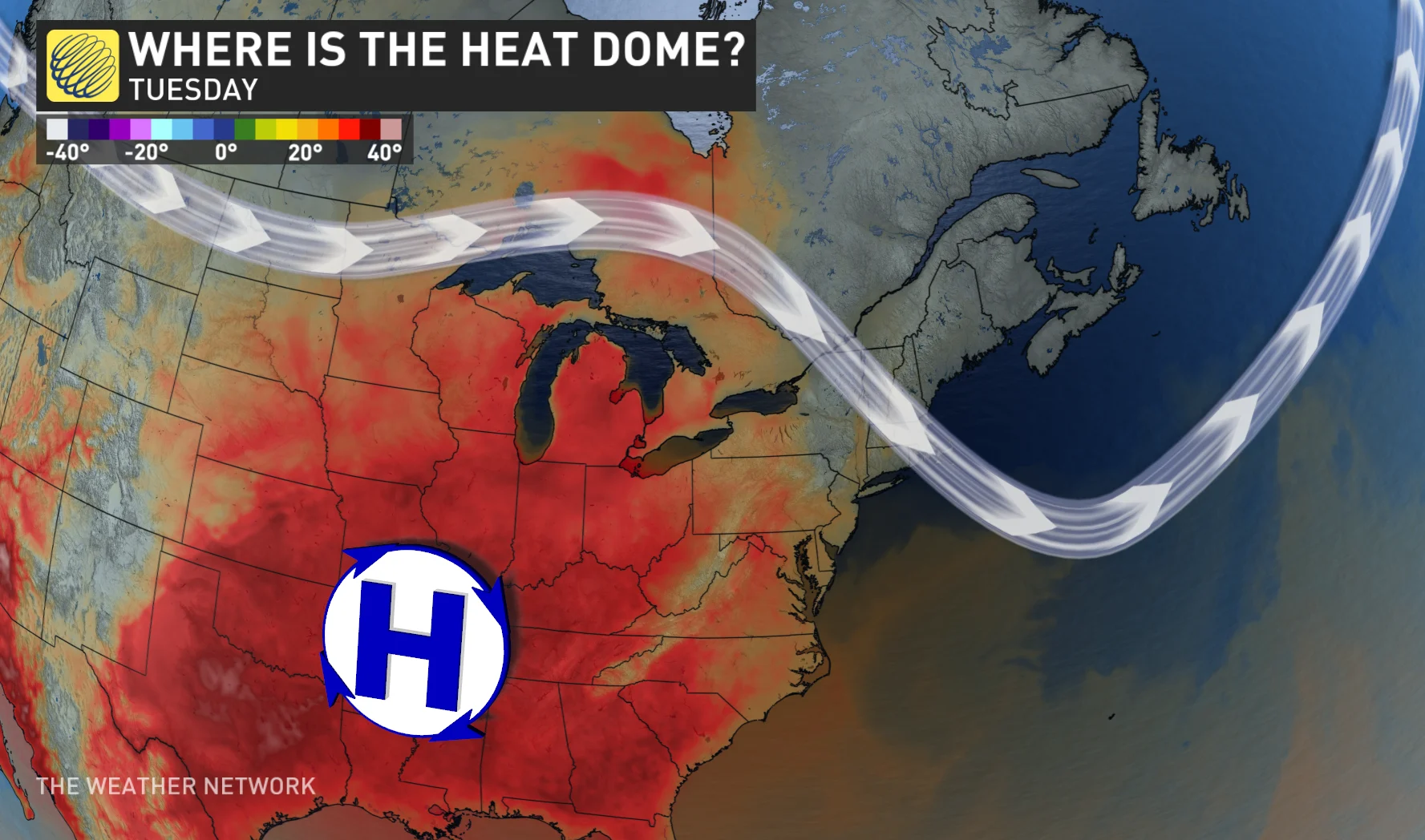
An unusually strong, sprawling ridge of high pressure south of the border will be responsible for trapping some of the hottest temperatures and humidex values so far this year, and on record for some.
"Check on older family, friends and neighbours. Make sure they are cool and drinking water," says Environment and Climate Change Canada in the warning. "Reduce your heat risk. Schedule outdoor activities during the coolest parts of the day."
READ MORE: If you’re hot, they’re hot – here are 6 things to help keep your dog cool
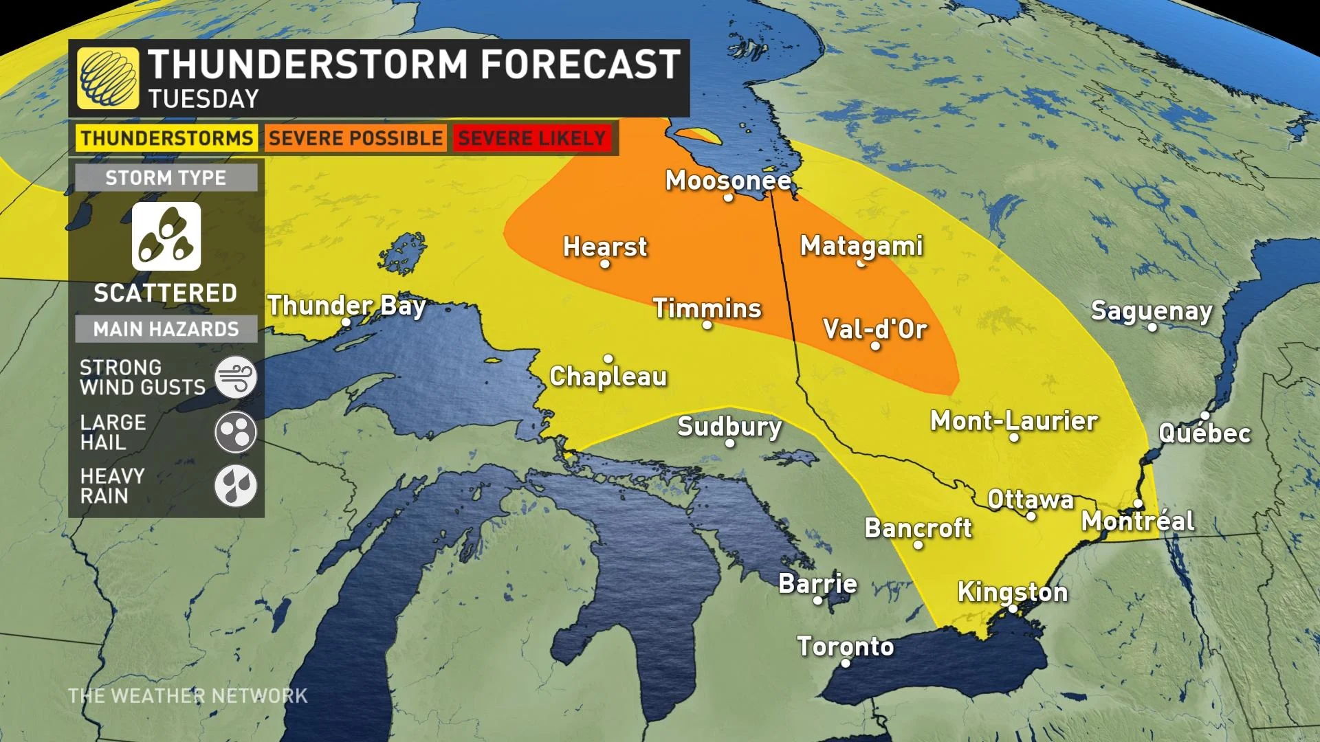
A warm front will slowly move east into northeastern Ontario and southern Quebec on Tuesday, providing a chance for a few thunderstorms to bubble up, possibly severe in some areas. They could bring large hail, heavy rain and strong wind gusts. Meanwhile, a non-severe threat extends into eastern Ontario and southern Quebec.
The bigger concern will be the extent of the heat, which will be widespread across the province for much of this week.
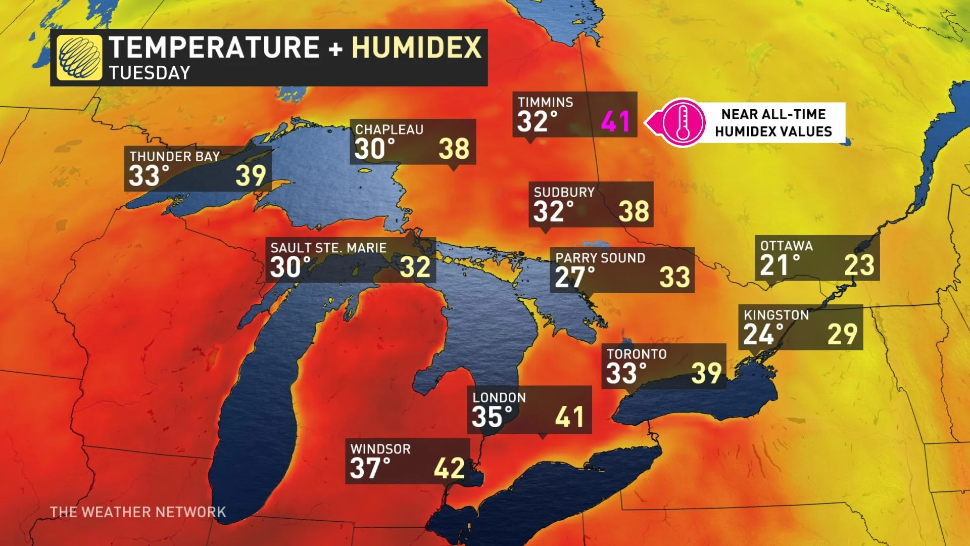
Humidex values will be in the high 30s and low 40s by Tuesday. Even Timmins, Ont., will be feeling like 41 on Tuesday -- coming close to tying its all-time record of 44 that was set on July 1, 1963. The city of Windsor is forecast to hit 37°C, with a humidex value into the low 40s -- making for some of the hottest temperatures of 2022 so far. If Windsor hits 37°C, it'll be the fourth warmest June day on record, and warmest day in the month since June 25, 1988 (40.2°C). That day happens to be the warmest day in the city's history.
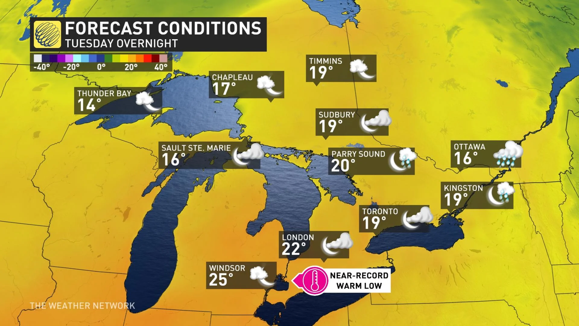
Tuesday overnight won't provide any relief from the heat, so it could be an uncomfortable sleep for many, even with the proper cooling equipment.
SEE ALSO: Heat is on the horizon. Here are 6 things you'll need to keep cool
It'll be a close call for Toronto with 34°C forecast at Toronto Pearson Airport. Temperatures would have to exceed 33.3°C to make for the warmest of the year so far.
"What makes this heat even worse is the fact that the overnight temperatures Tuesday night into Wednesday won't offer much of a relief," says Matt Grinter, a meteorologist at The Weather Network. "Even overnight temperatures are forecast to stay at 25°C in Windsor and around 20°C throughout the rest of southern Ontario providing no relief, especially for those without air conditioning."
For areas near the Great Lakes, wind direction will determine how hot it gets.
Although Sault Ste. Marie is usually sheltered from extreme heat by three Great Lakes, the city will experience an ideal wind direction from the Michigan Upper Peninsula on Tuesday that will send the humidex up to 38 before crashing to 19 on Wednesday.
Hot and very humid again Wednesday, with a chance of scattered thunderstorms as a cold front tracks across the region. Storms will be mostly widespread for eastern Ontario. Much lower humidity behind the front with near seasonal temperatures returning for Thursday but then the heat returns heading into the weekend.
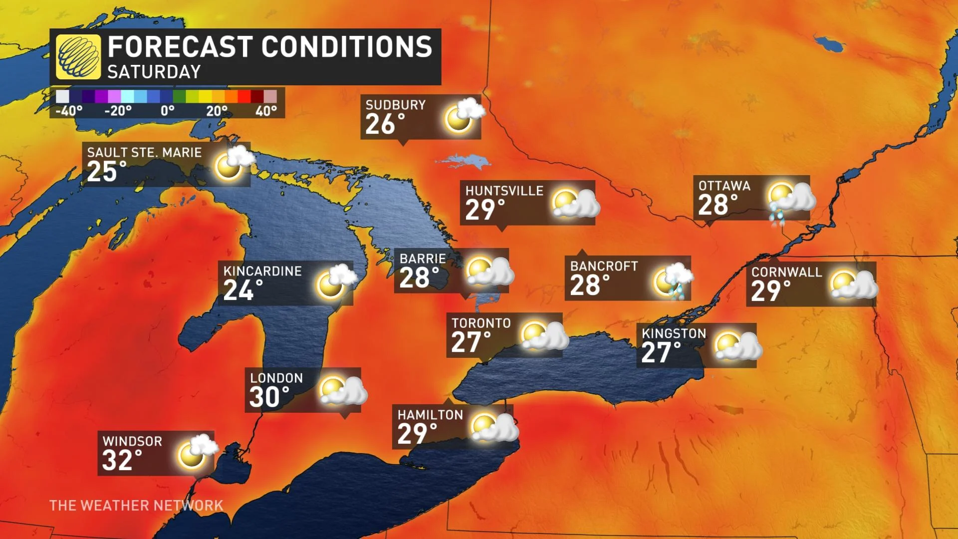
A stronger cold front will then track across the region Sunday with showers and thunderstorms followed by cooler weather for the start of next week. Temperatures are expected to be near seasonal, possibly even a few degrees cooler than seasonal for a couple days, during the final few days of June and through the Canada Day long weekend.
WATCH: HOW TO BEAT THE HEAT; TRICKS TO KEEP YOU COOL
Thumbnail courtesy of Michelle Valancius.
Stay tuned to The Weather Network for the latest forecast updates for Ontario.