
Finale of spring-like warmth in Ontario comes with thunderstorm risk

Thursday will be the final day of the stretch of spring-like weather in southern Ontario, soured by showers, strong winds, and perhaps even the first rumbles of thunder of 2021.
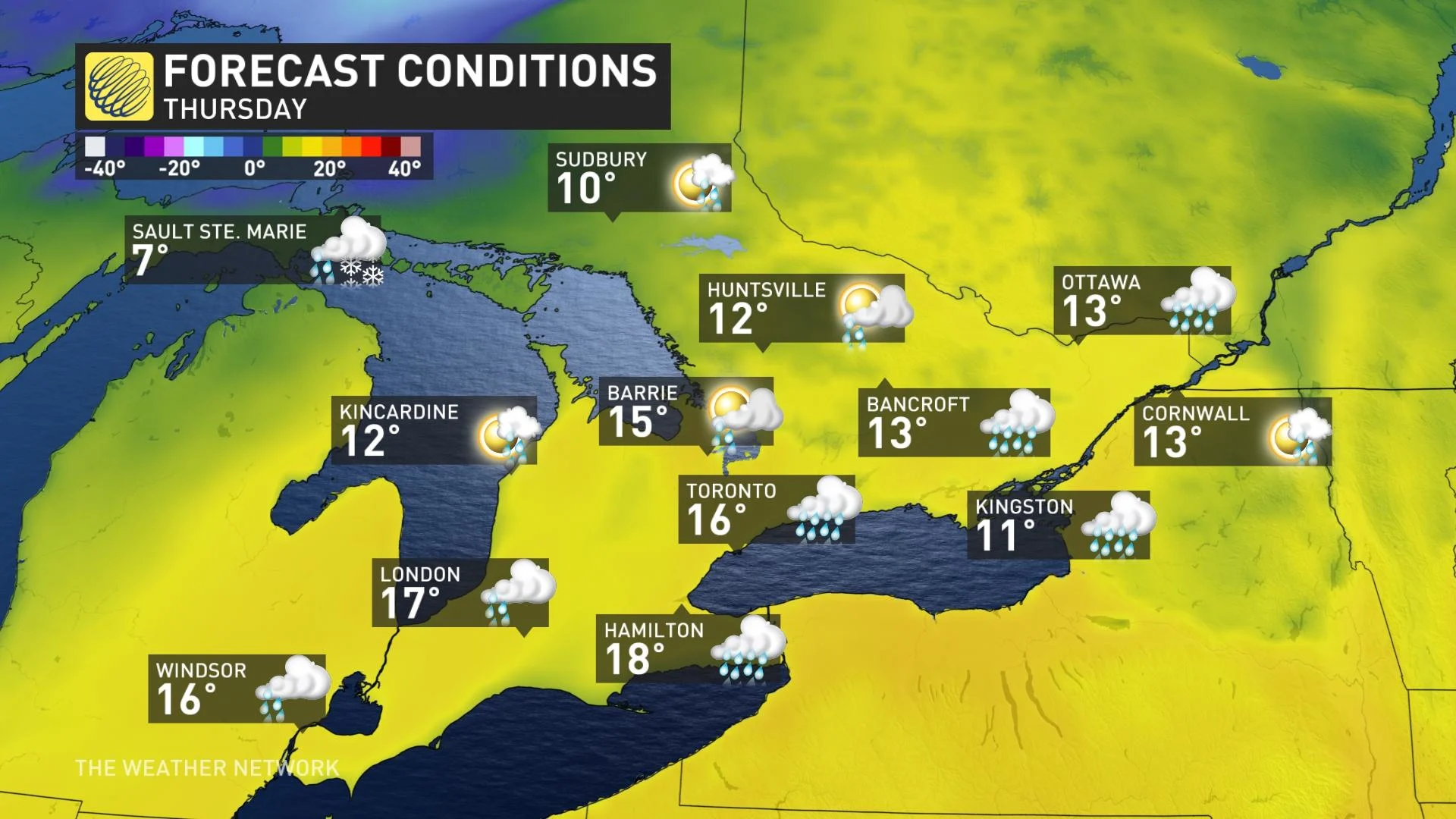
Ontario may have scored the first 20-degree temperature of the year in Canada Wednesday, with St. Catharines recording a preliminary daytime high of 20.1°C in the early afternoon. The late spring-like weather will continue Thursday, with the chance of another community hitting that mark. However, it will be the final day of warmth as a cold front is set to spoil the spring sneak peek, dropping temperatures to single digits for Friday.
Ahead of the front, there will be heavy, localized showers and even a slight chance of 2021's first thunderstorm. Winds will be blustery, so that may also put a bit of a damper on the warmth.
The north sees a completely different story -- a messier, wintry mix, with snow, freezing rain and ice pellets lingering into Thursday before the system departs. A closer look, below.
WEATHER HIGHLIGHTS
Thursday features another chance to hit 20°C for some areas
Wintry impacts with snow, ice pellets, freezing rain, rain continues in the north into Thursday morning
Widespread showers in the south late Thursday afternoon, with strong winds and slight thunderstorm risk
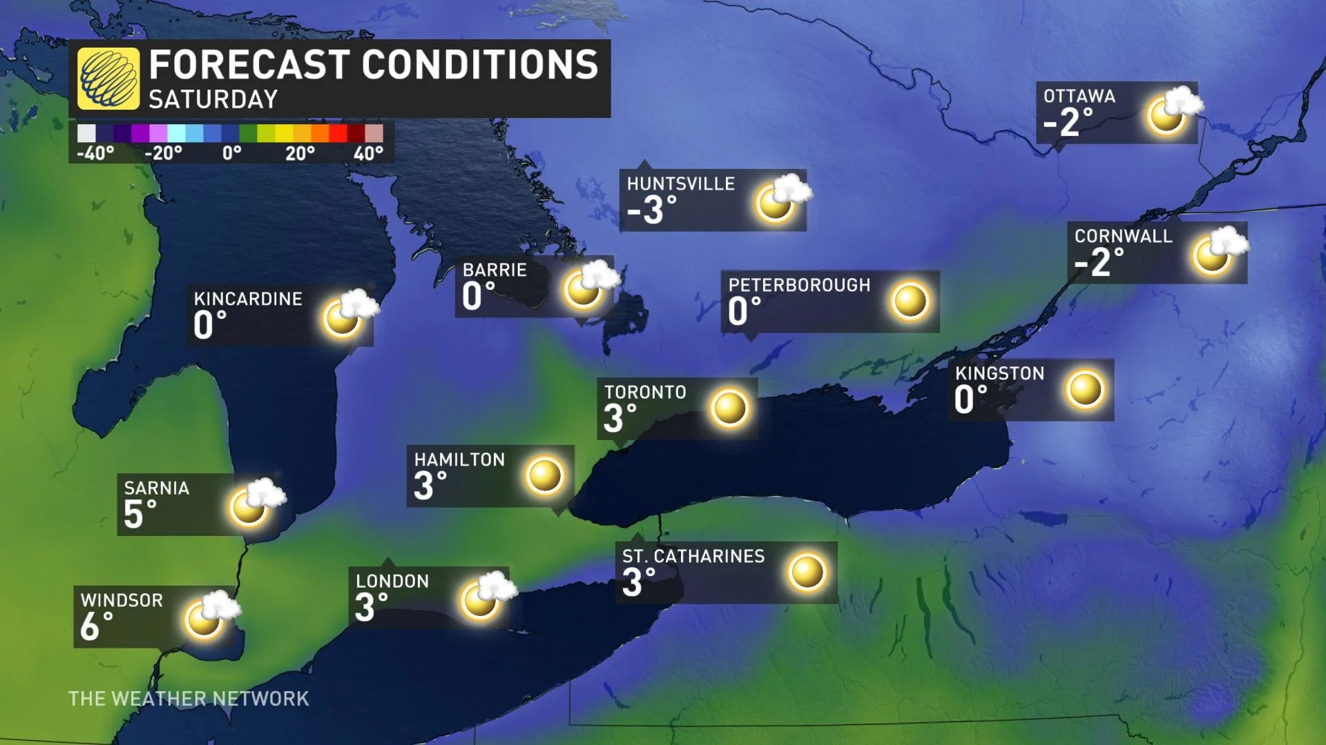
Near seasonal for the weekend
Visit our Complete Guide to Spring 2021 for an in-depth look at the Spring Forecast, tips to plan for it and much more!
THURSDAY: WARM TEMPERATURES FOR THE LAST DAY, ISOLATED STORM RISK
Thursday won't be a complete washout, as there will be plenty of dry breaks in between multiple rounds of showers. The first push will be a marginal risk, isolated in nature and will come through in the morning hours. There will be a break in the afternoon before the front treks in.
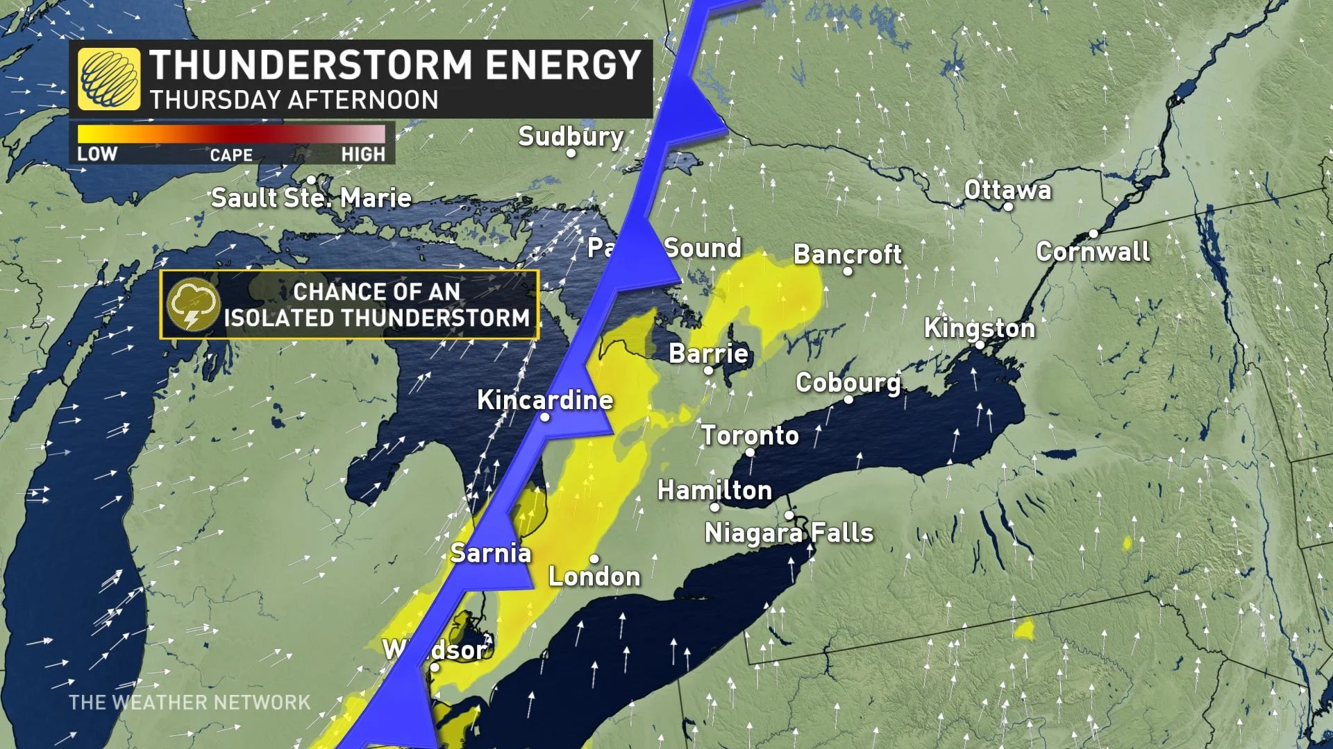
By late afternoon, a band of showers, localized heavy at times, will spread across the south. There will even be a little instability, so we can't rule out an isolated thunderstorm.
Temperature-wise, the late spring-like warmth that has been present most of the week will hang on for a final day. Widespread daytime highs into the mid- and upper-teens are anticipated, and similar to Wednesday, one or two areas may hit the 20-degree mark.
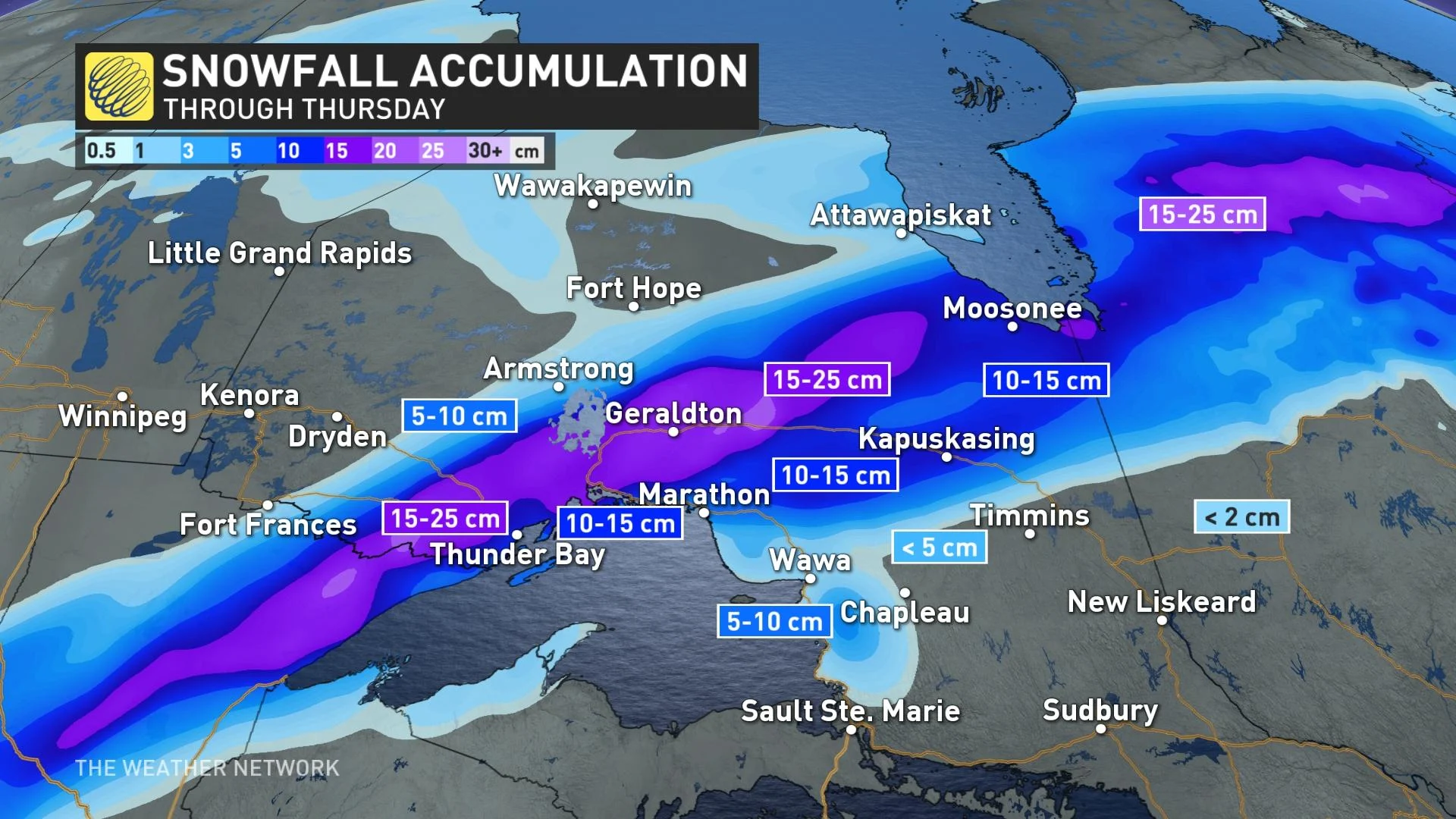
The north will be much cooler and on the wintry side of the same system that will impact the south. The region can expect a swath of heavy snow, rain, freezing rain and ice pellets into Thursday morning before tapering off.
The freezing rain threat will primarily be for a corridor along and north of Highway 101, including Timmins. This includes sections of Highway 17 and Highway 11. The section of Highway 17 between Wawa and White River could particularly be impacted by the freezing rain until early Thursday morning. The freezing rain will likely mix with ice pellets and snow overnight into Thursday morning. Motorists can expect difficult travel conditions during this time.
Areas in that freezing rain/ice pellets line are also likely to get the heaviest snow, in the 15-25-cm range, with lesser amounts elsewhere. Freezing rain, snow, and rainfall warnings are widespread across most of the north.
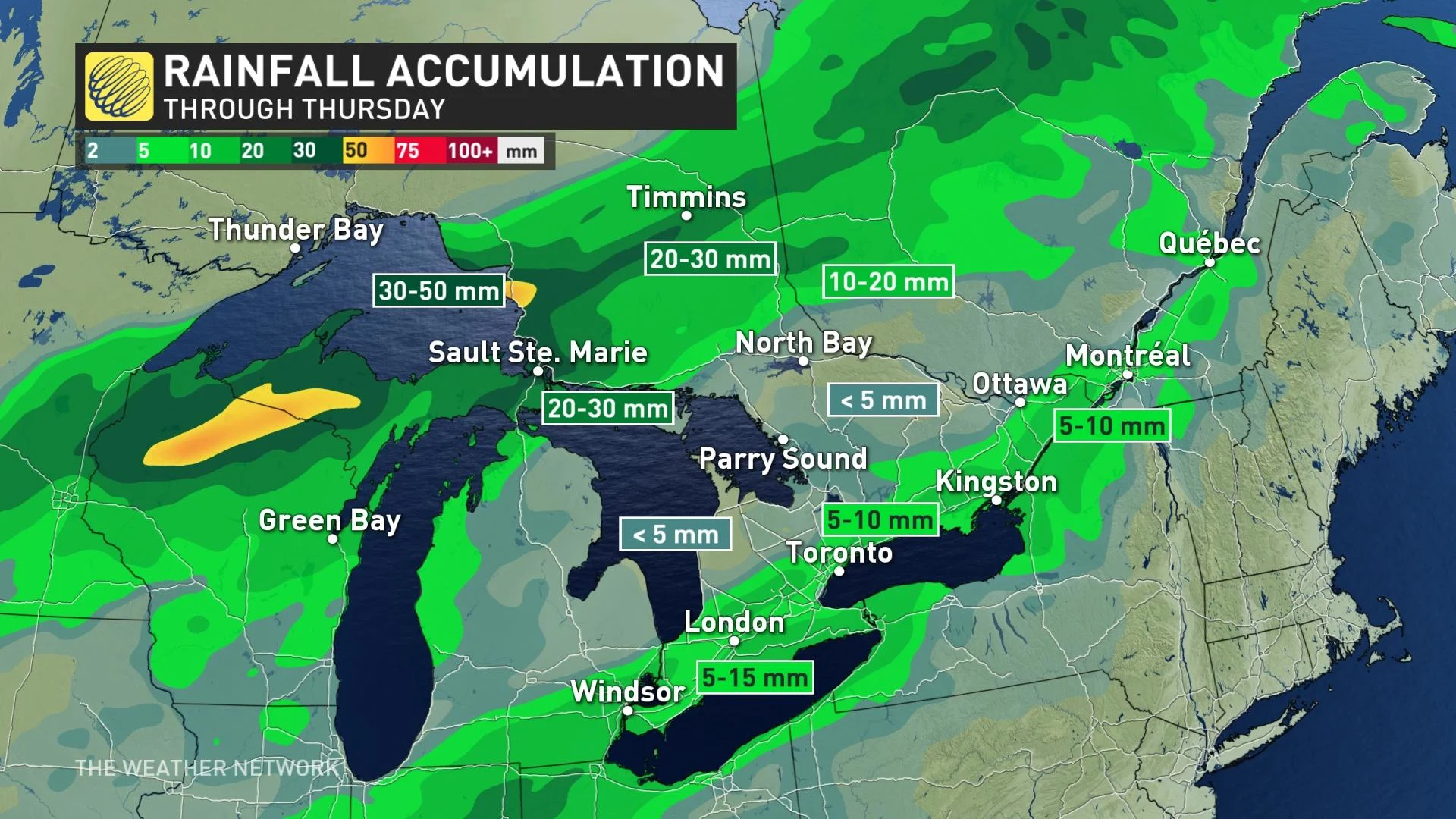
The rain in the south will peter out by the overnight hours Thursday. Amounts won't be excessive, though when combined with the very warm temperatures, it could lead to rapid snowmelt and possible localized flooding. General amounts of 5-15 mm are anticipated across the south, though locally higher amounts are possible if thunderstorms do fire up.
Speaking of those temperatures, they will drop considerably in comparison to what they are now by Saturday. Daytime highs will plummet to more near seasonal values, sitting in the low single digits.
WATCH: SUNNY DAYS CREATING DANGEROUS CONDITIONS ALONG RIVERS AND STREAMS
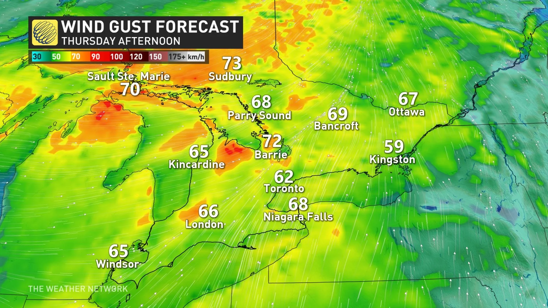
As well, what is helping to bring the warmth may make it a bit less enjoyable -- the gusty southerly winds. They will intensify Thursday afternoon, anticipated to hit the 60-80 km/h range, especially as the front moves through. This may be enough to cause some damage to unsecured structures.
BEYOND: CHANGEABLE, BUT COOLER, TEMPERATURE PATTERN
Sunnier conditions return by the weekend, but temperatures plunge to near seasonal levels, with even chillier weather for the early part of next week. Most of next week, however, will be more seasonal or on the cool side of seasonal for March -- in contrast to the warmth this week.
"Closely watching the system over the central U.S. to see if that will track far enough to the north to bring messy weather to the region on Tuesday/Wednesday, but it is possible that it will slide by to the south with strong high pressure over the region," Weather Network meteorologist Dr. Doug Gillham says.
Check back as we continue to monitor the forecast