
Warm and dry winter to dominate across much of U.S. south

Higher temperatures and near-normal precipitation await Canadian travellers to the southeastern U.S. this winter, but it's a more mixed bag elsewhere in the country.
The Weather Network's winter forecast for the U.S. this year shows some very defined temperature and precipitation patterns, especially across the western third of the country.
The warm ocean-atmosphere anomalies driven by the "Pacific Blob" will certainly have an impact on weather, but meteorologists say it won’t be as strong and persistent as that of 2015. As for other ocean-atmosphere signals, we can’t forget about the impact other phenomena may have, like the Arctic Oscillation (AO) or the Julian-Madden Oscillation (JMO).
Here's what Canadians should know before heading south this winter.
Florida and other southern U.S. destinations normally frequented by Canadians during the winter months are forecast to experience warmer and drier than average weather during the coming months.
Visit our Complete Guide to Winter 2019/2020 for an in depth look at the Winter Forecast for Canada, tips to plan for it and a sneak peek at the spring season next year
Certainly, it will be very different from last year, when California and other states experienced an exceptionally wet and cool winter, largely due to El Niño. This upcoming season, we expect neither El Niño or La Niña to shape the weather in this snowbird-favoured region.
The only relevant factor that may affect the season is what meteorologists call "Blob", a pattern of warmer-than-average sea-surface temperatures in the northeastern Pacific off the west coast of Canada and Alaska. For an idea of how it may make itself felt, we can look back to 2015, when a stronger Blob dominated northeastern Pacific, and the dominant atmospheric circulation pattern brought drier weather to the western third of the U.S., and heavier snow to the East Coast.
It should also be noted, however, that unlike this year, the anomalous 'Blob' occurred during an El Niño year, so we will have to wait and see what this year’s Blob has in store for us.
DRY WEATHER DOMINATES ACROSS MUCH OF THE WEST AND SOUTH
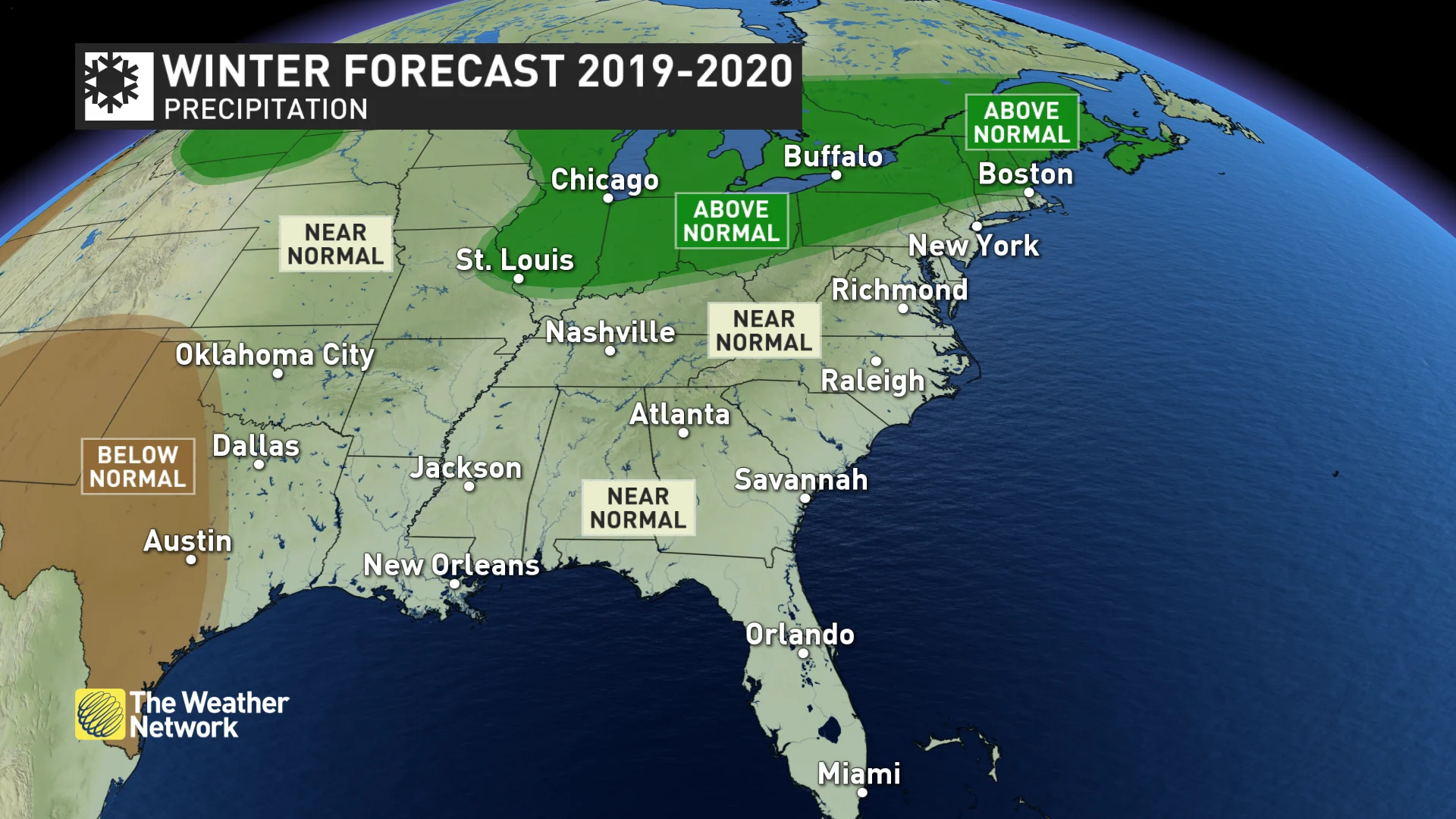
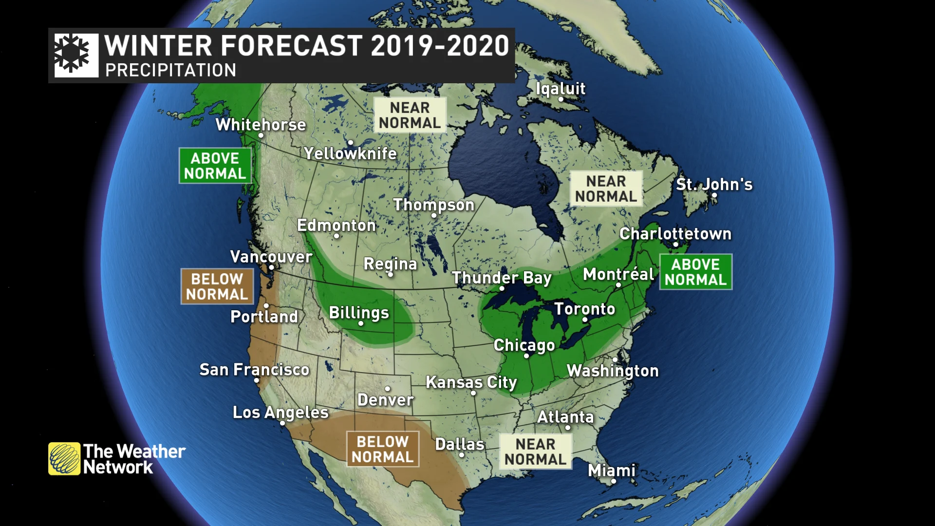
Across the contiguous U.S., The Weather Network’s winter forecast calls for above-normal precipitation across parts of Alaska, Montana, and a large swath extending from the Great Lakes into New England.
Below-normal precipitation, with the potential to enhance ongoing drought, is expected across much of the West Coast and south into Arizona, New Mexico and western Texas.
This precipitation pattern is very different from last winter’s El Niño pattern.
El Niño tends to energize the subtropical jet, which enhances precipitation across the southern states of the country. This winter, however, the atmospheric rivers that pump moisture into California and other parts of the southwest may not be as frequent.
As such, though last winter erased California’s intense, multi-year drought, this winter could see a return of drought conditions, and worsen the current drought scenario some southwestern states like Arizona, New Mexico, Colorado, Utah or Texas are experiencing.
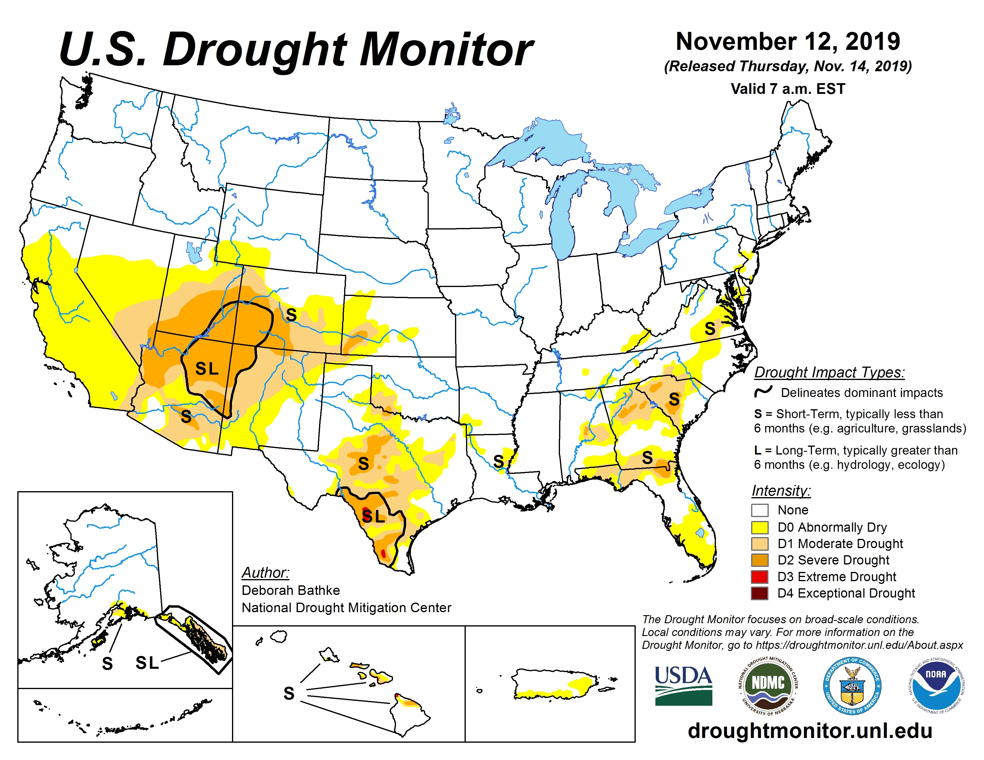
(Source: U.S. Drought Monitor)
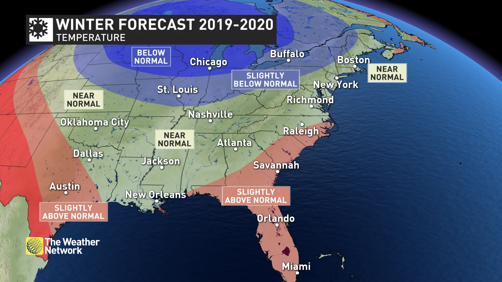
WARMER ACROSS MUCH OF THE WEST AND COOLER IN THE NORTH-CENTRAL STATES
For the western third of the U.S., there is a clear signal of an above-normal temperature trend for the winter months, extending from Alaska, through Washington and Oregon, south into California, Nevada, Arizona and portions of New Mexico and Texas. Slightly warmer weather is also expected in the southeast, from the Carolinas into Georgia and Florida.
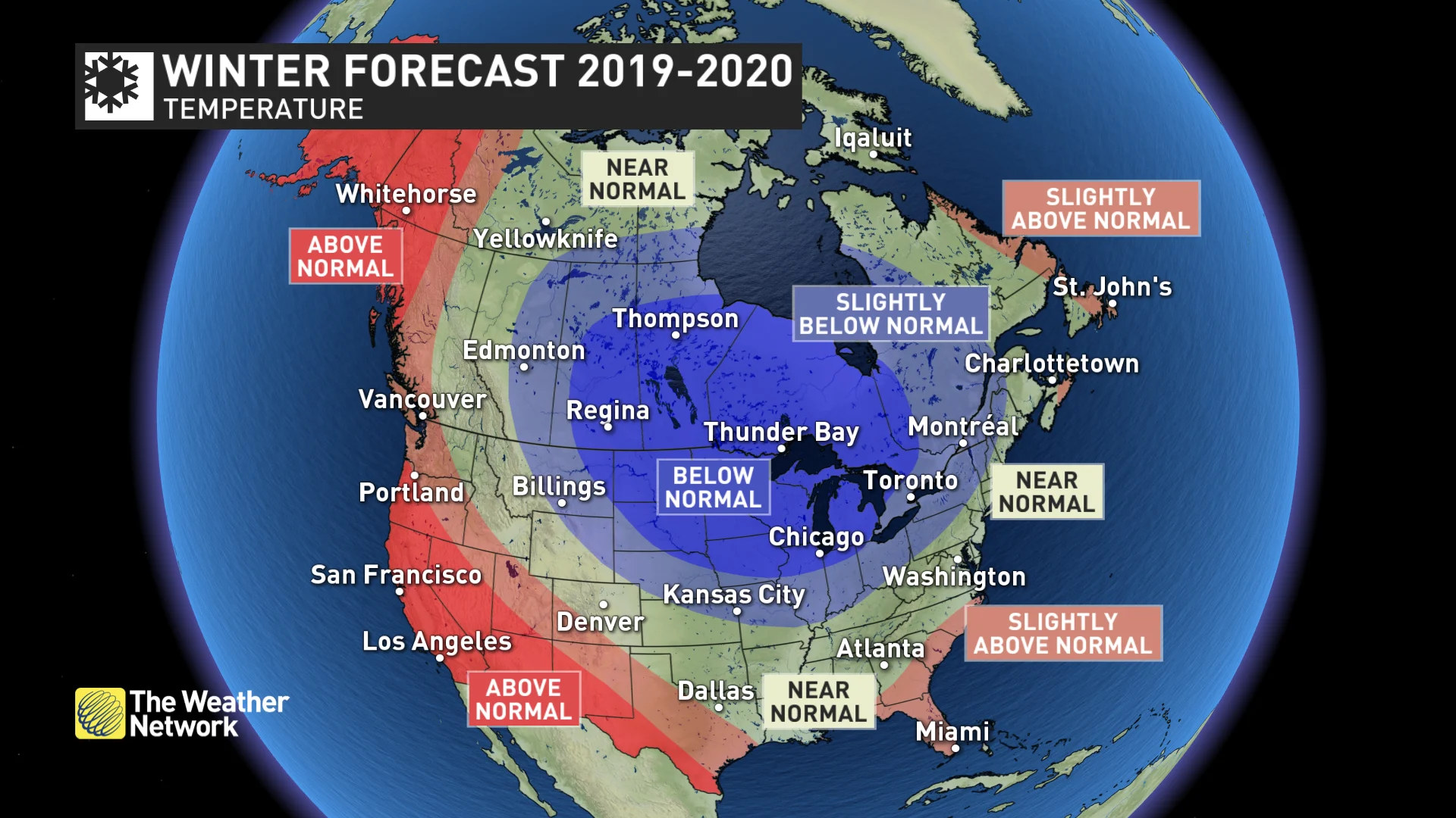
The opposite temperature anomaly is expected over the north-central states, with below-normal temperatures dominating in the Upper Plains and the Great Lakes region.