
Sharp cooldown on the western Prairies as storm threat shifts east

The Prairies have seen mostly everything Mother Nature can throw at them this week -- everything from sizzling mid-summer heat and severe thunderstorms to chilly temperatures, heavy snow and freezing rain. Tuesday saw severe thunderstorms fire up in parts of Alberta and Saskatchewan, but that threat will move into Manitoba and northwestern Manitoba Wednesday. Meanwhile, Alberta sees a dramatic cooldown, and even some snow, with huge flakes covering central sections by Tuesday night. Northern Manitoba will continue to see heavy snow and freezing rain Wednesday, all thanks to an amplified pattern over the region that looks to bring widepsread cooler weather by the end of the week. More on the storms and the temperamental side of spring, below.
WEDNESDAY: COOLDOWN WITH SNOW ACROSS WEST, SEVERE THUNDERSTORM THREAT MOVES EAST
While severe thunderstorms moved out of Alberta Tuesday evening, storms continued to roll through eastern Saskatchewan in the overnight period. Earlier Tuesday, some of the thunderstorms produced hail, local downpours and gusty winds. Footage of hail in the community of Ponoka, Alta., surfaced on Twitter.
MUST SEE: Prince Albert declares state of emergency, partial evacuation as forest burns
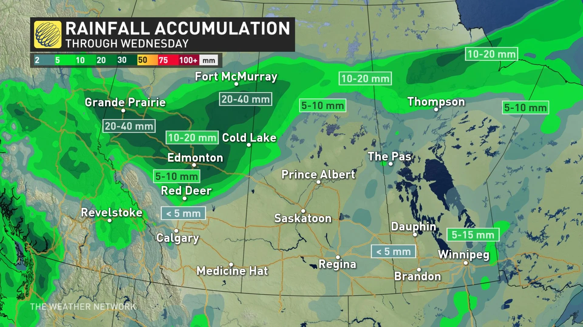
Much cooler air is on the way in Alberta once the front passes through, with wet flurries reported across the Edmonton area Tuesday night.
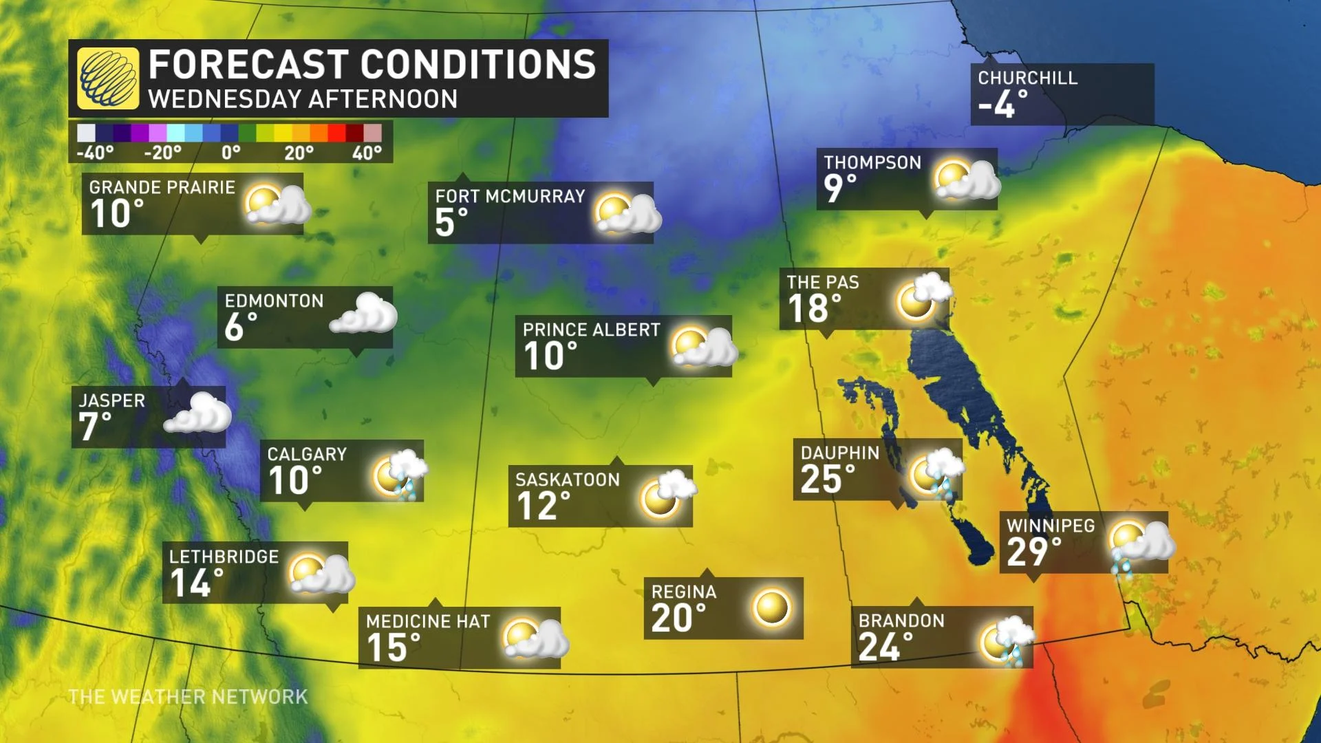
On Wednesday, much of the eastern parts of the Prairies will hold on to warmer temperatures, but single-digit highs will be likely for many in Alberta after the strong cold front crossed the region.
Special weather statements are already in effect over central and northern Alberta, warning of the cooler air spreading over the region, which could switch the rain over to snow.
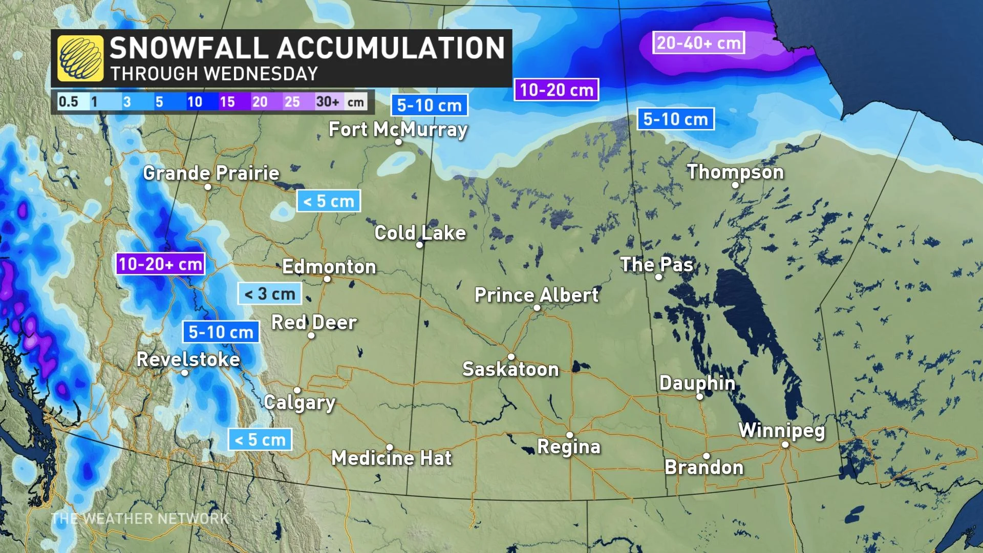
The heaviest accumulations are expected in northeastern Alberta, with 5-10 cm possible by Wednesday night. Drivers are urged to prepare for poor travel conditions throughout the day, with the potential for broken tree branches with the heavy wet snow piling up as well.
"Intrigued and a bit concerned with the threat for very heavy wet snow for southwestern Alberta, especially the southern Rockies and foothills, and southwestern Saskatchewan (Cypress Hills area) Wednesday night through Thursday night," says Dr. Doug Gillham, a meteorologist at The Weather Network.
While these are relatively sparsely populated areas, there is a significant risk for tree damage with some rather impressive snow totals, Gillham adds, and a very dense, heavy wet snow for the higher terrain. Some significant snow is also possible for the Prairies east of the Rockies.
Meanwhile, Wednesday will see the thunderstorm threat shift east of Winnipeg along the Manitoba and Ontario border, as the front continues to push across the region. Southeastern areas of Manitoba and parts of northwestern Ontario could see the chance for some storms to reach severe limits.
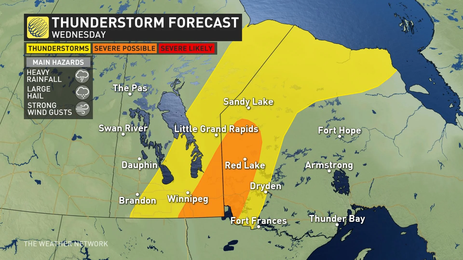
The main threats are heavy rain, large hail and strong wind gusts.
WINTER STORM WARNINGS COVER PARTS OF NORTHERN MANITOBA
Much cooler temperatures and Pacific moisture will continue to impact northern regions of the Prairies.
A low pressure system is set to bring a mix of wintery weather to extreme northern Manitoba through Wednesday. Associated with this low-pressure system, a band of freezing rain is forecast to develop from Brochet eastward to south of Churchill. Freezing rain will transition to snow during the day Wednesday.
North of this band of freezing rain, heavy snow will be the issue. Snow falling in the communities of Lac Brochet, Tadoule Lake and Churchill and will continue until Wednesday night. The snowfall will intensify and will begin to accumulate quite rapidly into Wednesday.
Hefty totals of 20-40+ cm could pile up through Wednesday.
In addition to the precipitation, strong northerly winds are also forecast with this system, so reduced visibilities in blowing snow can be expected, specifically in Churchill.
"Consider postponing non-essential travel until conditions improve. Prepare for quickly changing and deteriorating travel conditions. Visibility may be suddenly reduced at times in heavy snow. Ice build-up may cause tree branches to break," warns Environment Canada in the winter storm warning for the region.
Conditions will begin to improve Wednesday night.
LOOK AHEAD: TEMPERATURES QUICKLY PLUNGE, THREAT FOR WET SNOW AND POOR TRAVEL
Most of the Prairies will finish the week with cool and unsettled conditions, as cloud cover and rain showers persist and temperatures remain below seasonal under the upper level trough.
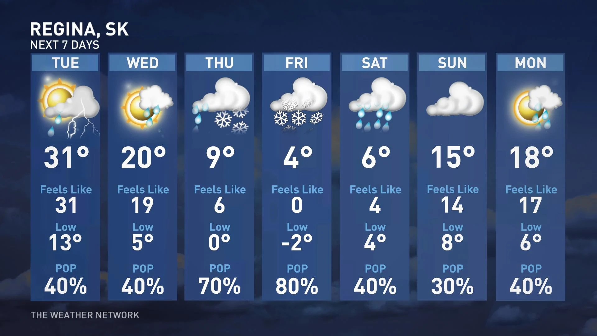
Quite the wild contrast to the summer-like heat that starts the week, but also an opportunity for some much needed rain for parts of southern Saskatchewan and southern Manitoba.
There will be a wide range in rainfall totals, with between 25-75+ mm expected through early next week. Some of that rain may also mix with a bit of wet snow, as moisture presses back into the cool air mass settling in across the region.
Unfortunately, it looks like parts of southern Alberta and into central Saskatchewan, (including Lethbridge, Medicine Hat, Swift Current and Saskatoon) will miss out on the beneficial rains, as the storm track will be north and south of this region.
Still, a coating of wet snow is likely for parts of southern Saskatchewan Thursday night and Friday.
Temperatures will begin to recover as we go through the long weekend, with daytime highs in the upper teens to lower 20s expected for parts of the region.
Be sure to check back for the latest updates on the changing spring conditions across the Prairies.


