
Hurricane warnings issued as Storm Barry stalks Louisiana coast

Tropical Storm Barry threatens dangerous storm surge and more flooding in Louisiana
Still looming off the U.S. Gulf Coast, Tropical Storm Barry continues to gather strength south of Louisiana. Hurricane warnings are now in effect for parts of the Louisiana coast threatened by dangerous storm surge, flooding rain, and powerful winds as we head into the weekend. It's not just the immediate coast that needs to watch out for this storm, however, as drenching rains will test a Mississippi River basin that's already seen record flooding this year. We take a look at the latest on this storm, below.
STORM HIGHLIGHTS:
Barry reached tropical storm strength Thursday morning, could become a hurricane before landfall
Track suggests landfall in Louisiana on Saturday
Flooding rain, storm surge greatest risks
Numerous storm-related watches and warnings in effect along coast
A state of emergency is in effect for Louisiana as it awaits the arrival of Barry, which reached tropical storm strength Thursday morning as it continued to drift westward over the northern Gulf of Mexico. Flooding is already underway for the Gulf state, where waters will continue to rise as the storm pushes toward the coast.
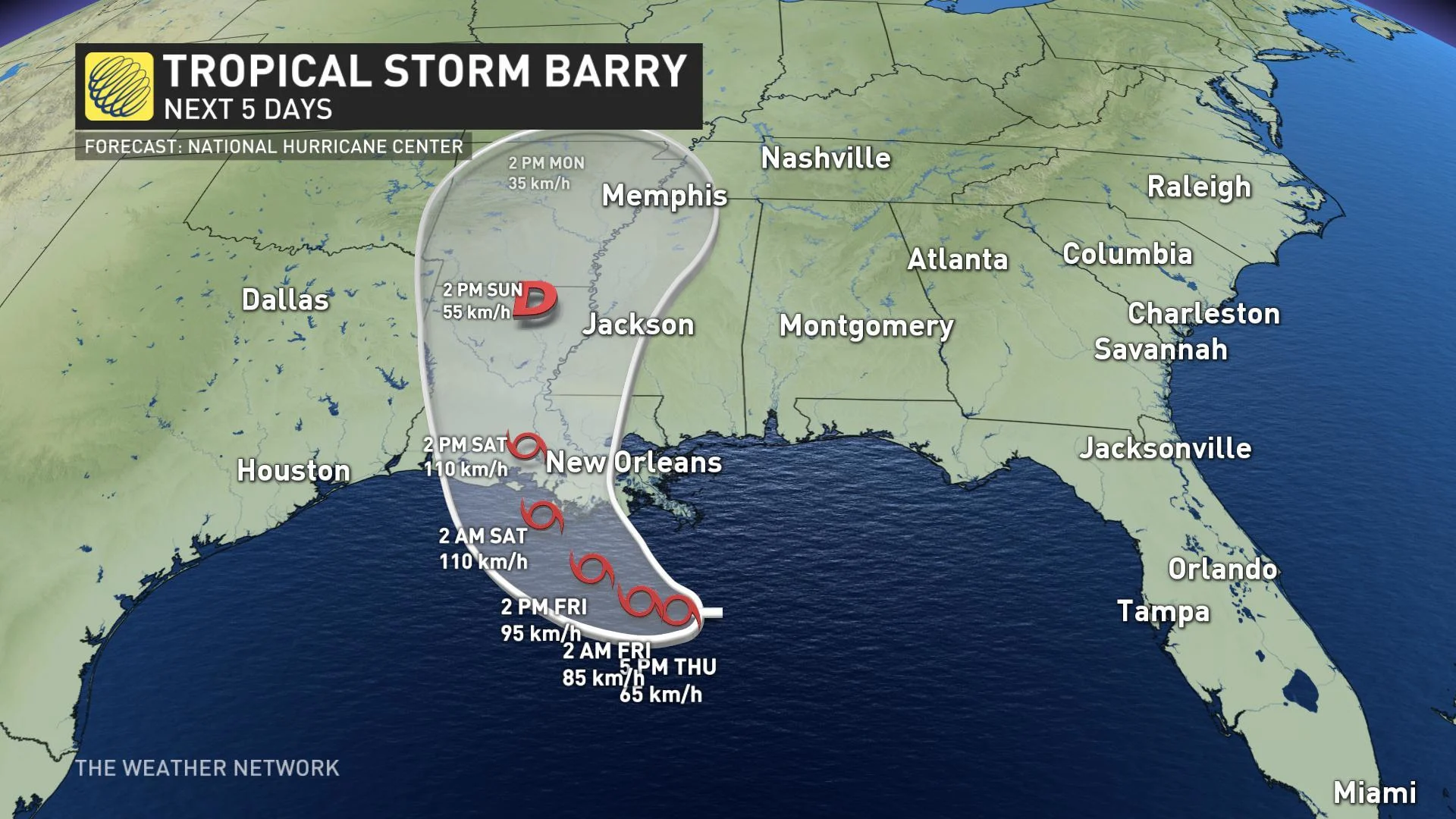
A storm surge warning is in effect for a stretch of Louisiana coastline south of New Orleans stretching from the mouth of the Atchafalaya River to Shell Beach where waters may rise as much as 6 feet (1.8 metres) above normal.
"The more information we get, the more concerned we are that this is going to be an extreme rain event," Louisiana Governor John Bel Edwards said at a news conference on Thursday. "If Tropical Storm Barry becomes a hurricane, it would be the first time we've had the hurricane hit the state with rising rivers."
National Guard troops are already in place across the state with mandatory evacuations ordered for some 10,000 people across parts of the east bank of Plaquemines Parish.
New Orleans Mayor LaToya Cantrell warned Thursday that 48 hours of heavy rainfall could overwhelm pumps that the low-lying city uses to purge its streets and storm drains of excess water, leading to flooding as early as Friday morning.
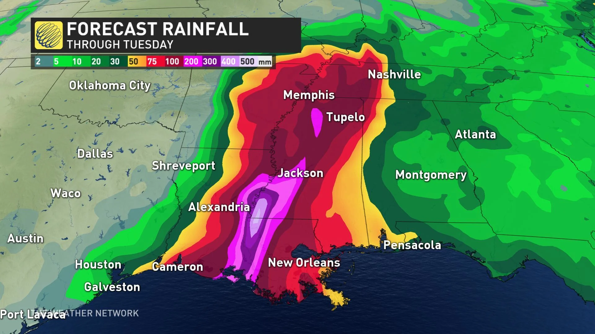
MAJOR IMPACT FROM HEAVY RAIN, STORM SURGE
While winds will be a concern with the storm -- which may still reach hurricane strength before landfall -- the real threat is from water, both in the form of flooding rains and storm surge. Water driving into the coast, along with more than 6 inches (150 mm) of rain in just a few hours, had already sparked flooding in New Orleans on Wednesday.
RELATED: How this weird storm may be 2019's next hurricane
WATCH BELOW: FLOODING WORSENS IN NEW ORLEANS AHEAD OF STORM
Water levels are expected to continue rising through the end of the week as the storm makes its way toward a western Louisiana/eastern Texas landfall. Depending on how fast the storm moves, some 400+ mm of rain are possible for parts of the coast over the next five days with the risk for as much as 500 mm in some isolated areas.
"The whole area is in for a soaking, the worst of it on Saturday," said David Roth, a meteorologist from the National Weather Service's Weather Prediction Center.
Residents have been urged to stock up on emergency supplies, with some evacuations ordered in more vulnerable areas.
WILD: BACKYARD PLAY STRUCTURE IS ABSOLUTELY DEMOLISHED
With files from Reuters.