Wind gusts intense enough to topple trucks blast through Alberta

Intense Chinook winds will continue to pose a travel threat across the southern Alberta foothills into Tuesday morning.
The week started on a windy note across southern Alberta, with intense gusts approaching 100 km/h in parts of the region Monday. They are enough to be considered trucking-tipping. A low-pressure system moving east across the Prairies helped kick-start downsloping winds along the southern foothills, also generating blowing dust that has created hazardous travel conditions. The blowing dust is expected to continue while winds remain strong through Monday overnight, then winding down Tuesday morning. Meanwhile, with milder air in place, some locales in the south end could hit the mid-teens by Thursday. More on the wind impacts in Alberta and when to expect them to subside, and what to expect the rest of the week, below.
TUESDAY AND BEYOND: WINDS CALM DOWN, WARM TEMPERATURES REMAIN
A low-pressure system that is trekking across the Prairies is bringing howling winds along the Rockies in a typical chinook event for the southern half of Alberta, with downsloping winds generating gusts that could be considered truck-tipping in some locales. Wind warnings are in place.
"Near zero visibility in blowing dust has been observed and is creating hazardous travel conditions. The blowing dust is expected to continue while winds remain strong," said Environment and Climate Change (ECCC) in the wind warning.
Winds will remain intense across southern Alberta overnight Monday into Tuesday. Some communities will still have to deal with blustery conditions on Tuesday, as well, though not nearly as potent as Monday.
We’ll see a stark temperature divide set up across the Prairies this week. A brief warm-up will spread east on Tuesday, potentially giving Winnipeg its first above-freezing reading since Dec. 15.
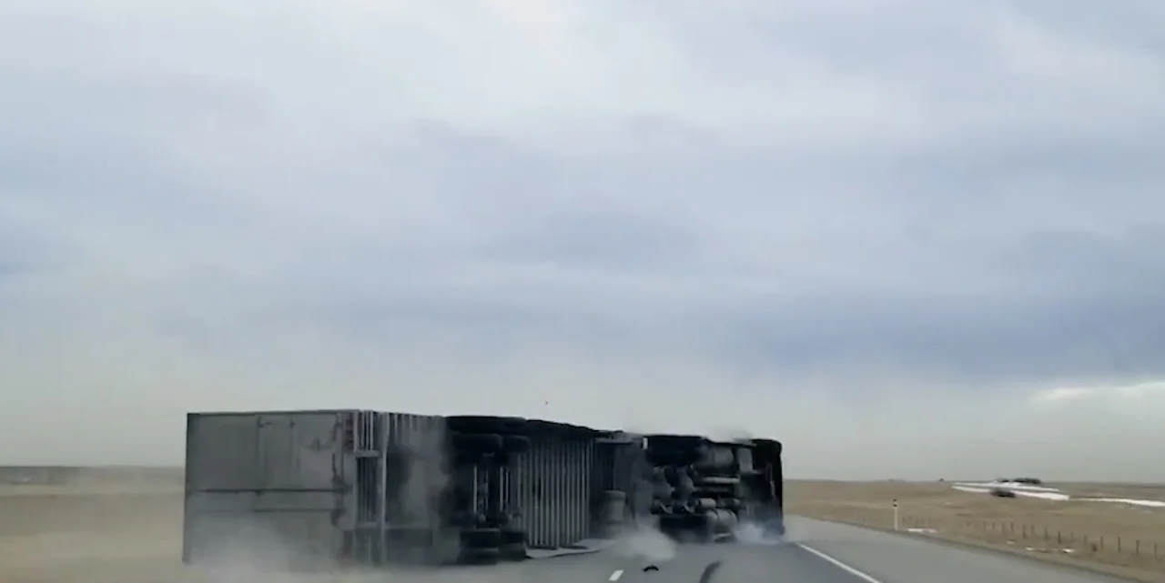
WHAT ARE TRUCK-TIPPING WINDS?
Winds were reported to be of truck-tipping intensity Monday. So, what exactly does that mean?

Truck-tipping winds refer to gusts strong enough to topple trucks, literally. These strong winds can be common in the southern foothills of Alberta, where downsloping winds from the Rockies can reach strengths exceeding 100 km/h.
But there are other factors involved including the weight of the vehicle and how strong the wind gust is.
“If the truck is empty, a quick gust can blow it over, for example,” said Melinda Singh, a meteorologist at The Weather Network. "But, if the truck contains heavy merchandise, it might take a stronger gust."
WATCH: WINDS BLOW WITH THE FORCE OF TEN GRIZZLY BEARS IN ALBERTA, ENOUGH TO TOPPLE TRUCKS
Looking beyond Tuesday, the overall pattern, though, will be a sharp contrast between the West and the East. An upper-level ridge will lock above-seasonal temperatures over Alberta and parts of Saskatchewan into next weekend, while a trough keeps Manitoba’s chilly highs well below seasonal over the same period.

Temperatures in Alberta will soar late week, with daytime highs surging into the mid-teens in the southern portion and upper single digits in the north. A rather stark contrast to what the province experienced earlier this winter.
Meanwhile, a strong clipper will rapidly intensify as it quickly tracks from northern Alberta to central Manitoba on Thursday. A swath of 10-15 cm of snow, but primarily north of populated areas.
Stay tuned to The Weather Network for the latest conditions across Alberta.