Wild temperature pattern has Ontario as cold as Alert
Fall -- and it is still fall, technically, even though many Canadians can look outside and see snow right now -- has a well-earned reputation for wild temperature swings. That temperamental nature has been on excellent display this week across North America, as temperatures dip to the freezing mark along the coast of the Gulf of Mexico while hitting the upper teens in Atlantic Canada, and parts of southern Ontario wake up colder than Ellesmere Island.
BITING COLD: SOUTHERN ONTARIO MATCHES HIGH ARCTIC
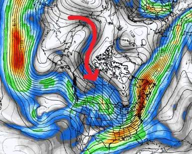
The jet stream plays a crucial role in our temperature pattern, and this setup is no exception. Early-season cold temperatures are flooding much of eastern North America this week as the jet stream dips low over the Great Lakes. While it's early in the season for true 'cross-polar flow' -- where the jet funnels air directly from Siberia into eastern North America -- the current cold blast did get a helping hand from the far side of the Arctic earlier this week.
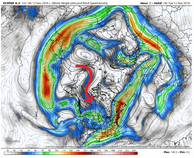
Model depiction of winds at the 200 millibar level in the atmosphere over the Northern Hemisphere. The red arrow shows the flow of the Arctic jet, connecting Siberia and North America. Image courtesy WeatherBell.
Toronto, Hamilton, and Ottawa airports all set new record lows Wednesday morning, as temperatures dipped into the minus teens, blasting past records set in 1986. New records were also set in Peterborough, Brantford, Barrie, Windsor, and Sarnia, among others. Thanks to this direct freezing flow, CFB Borden, near Barrie, dropped down to -24ºC under clear skies early Wednesday while Alert, Nunavut -- the northernmost permanently inhabited place on Earth -- was only -25ºC. Just after dawn at Base Borden, the temperature in the two places was the same at -23ºC (though, to be fair, sunrise in Alert won't happen now until next February).
UNLIKELY HOT SPOT: NEWFOUNDLAND TOPS CALIFORNIA
If we look back up at that map, you might notice the same jet that's bringing cold air to the Great Lakes sails north over Atlantic Canada. Just as it does for the middle part of the continent, that translates to the temperature pattern out east, too.
Atlantic Canada was one of the continent's hot spots on Wednesday, with an unlikely suspect -- St. John's, Newfoundland -- leading the way with a high of about 16ºC. That's not only about 10 degrees above average for this time of year. It was also keeping pace with the temperature in Los Angeles this morning, and tied with the high further north in San Francisco.
Unlike their SoCal cousins, however, Newfoundland's hot streak isn't going to last. A cold front cutting through by Thursday morning will shove temperatures back to seasonal -- and even below -- for the rest of the week.