Prairies: Tornado confirmed in Alberta, stubborn storm threat lingers

The threat for thunderstorms treks eastward on Thursday as a widespread heavy rain continues across parts of the northern Prairies
At least one tornado was caught on camera on Wednesday amid another day of severe thunderstorms for parts of the Prairies. This came after intense thunder and lightning erupted over the region with 12,000+ lightning strikes reported in Alberta alone. The strong storm threat will shift east into parts of southern Manitoba and northwestern Ontatio through Thursday as heavy rain and strong winds whip up over the western Prairies. We take a look at the persisting storm threat to close out the week and the next system that quickly develops behind it for the weekend, below.
Summer revealed! Visit our Complete Guide to Summer 2019 for an in-depth look at the Summer Forecast, tips to plan for it and much more
WEATHER HIGHLIGHTS:
Tornado confirmed in Alberta Wednesday afternoon
Front will redevelop Thursday in northwestern Ontario, severe risk continues
Another system develops east of the Rockies Friday night, tracking across the central and northern Prairies through the weekend
Stay up-to-date on the weather ALERTS in your area
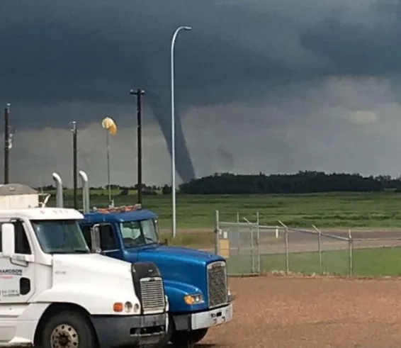
CAUGHT ON CAMERA: TORNADO NORTHEAST OF EDMONTON
Storm-spotters near Waskatenau, Alberta, northeast of Edmonton, captured a stunning storm on Wednesday afternoon, just before 2 p.m. local time. The tornado developed with a supercell storm tracking to northeastward through the region amid a swath of severe thunderstorm watches and warnings.
Environment Canada issued a statement confirming the tornado and giving it a rating of EF-0, the weakest on the Enhanced Fujita Scale, with estimated winds of 90 to 130 km/h. No damage was reported from the storm.
WATCH BELOW: BREAKING DOWN THE WASKATENAU TORNADO
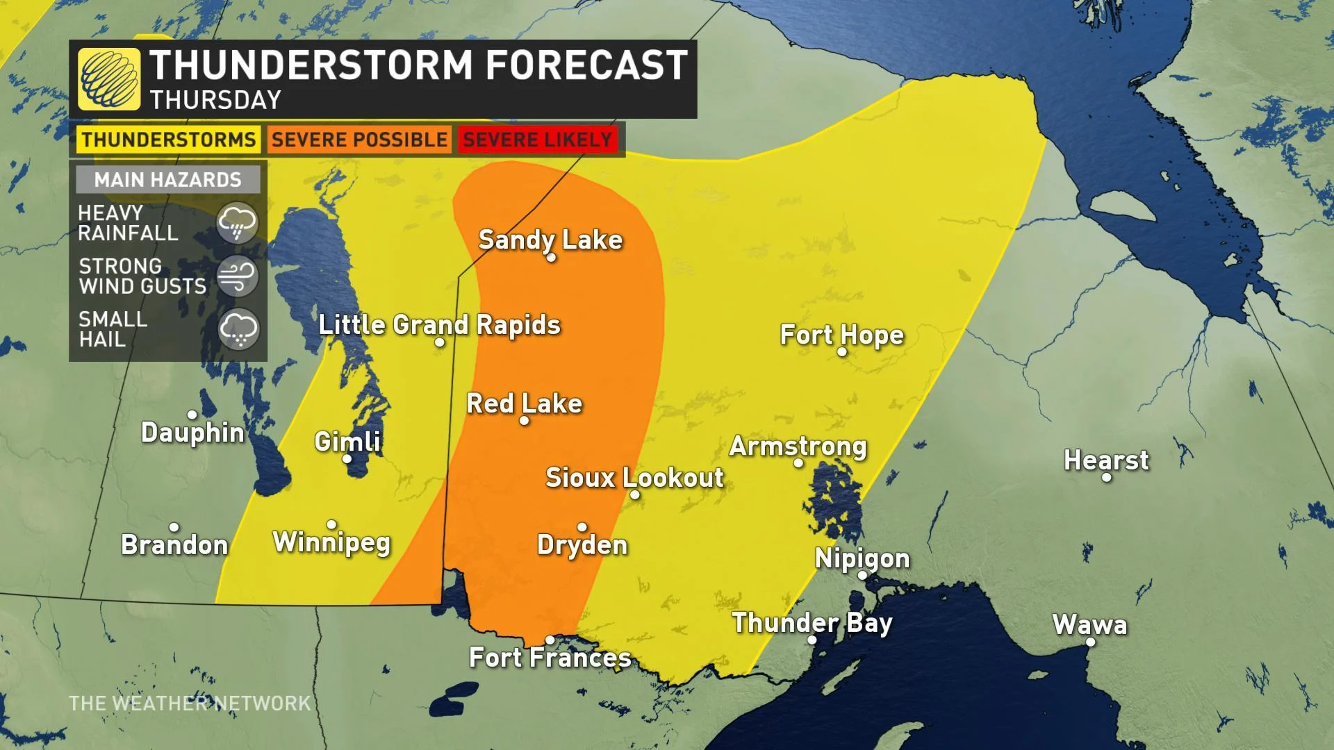
STORM THREAT SHIFTS FURTHER EAST ON THURSDAY
Strong thunderstorms persisted through the early morning hours for parts of the Prairies once again on Thursday as the low pressure centre begins its march east, targetting southern Manitoba and northwestern Ontario with the next round of storms.
"We'll see just a few embedded thunderstorms across northcentral Alberta and along the border with Saskatchewan as the threat for storms pushes into northwestern Ontario Thursday afternoon and evening," says Weather Network meteorologist Nadine Powell. "We're not really expecting strong supercells with rotation as wind shear is not as prominent as it has been earlier this week."
SEE IT: "Intense" lightning storm wakes up Alberta, 4,000+ strikes detected
Widespread rain will continue across the northern Prairies through Thursday however, along with an area of strong winds that develop behind the cold front.
Gusts in excess of 80 km/h will sweep across central Alberta and central and southern Saskatchewan as the low shifts eastward on Thursday. An upper trough spinning back towards central Saskatchewan may also enhance the chance for funnel cloud sightings over places like Prince Albert and Saskatoon.
WATCH BELOW: TIMING THE POTENTIAL FOR DAMAGING GUSTS
RELATED: Why people ignore severe weather warnings (or do they?)
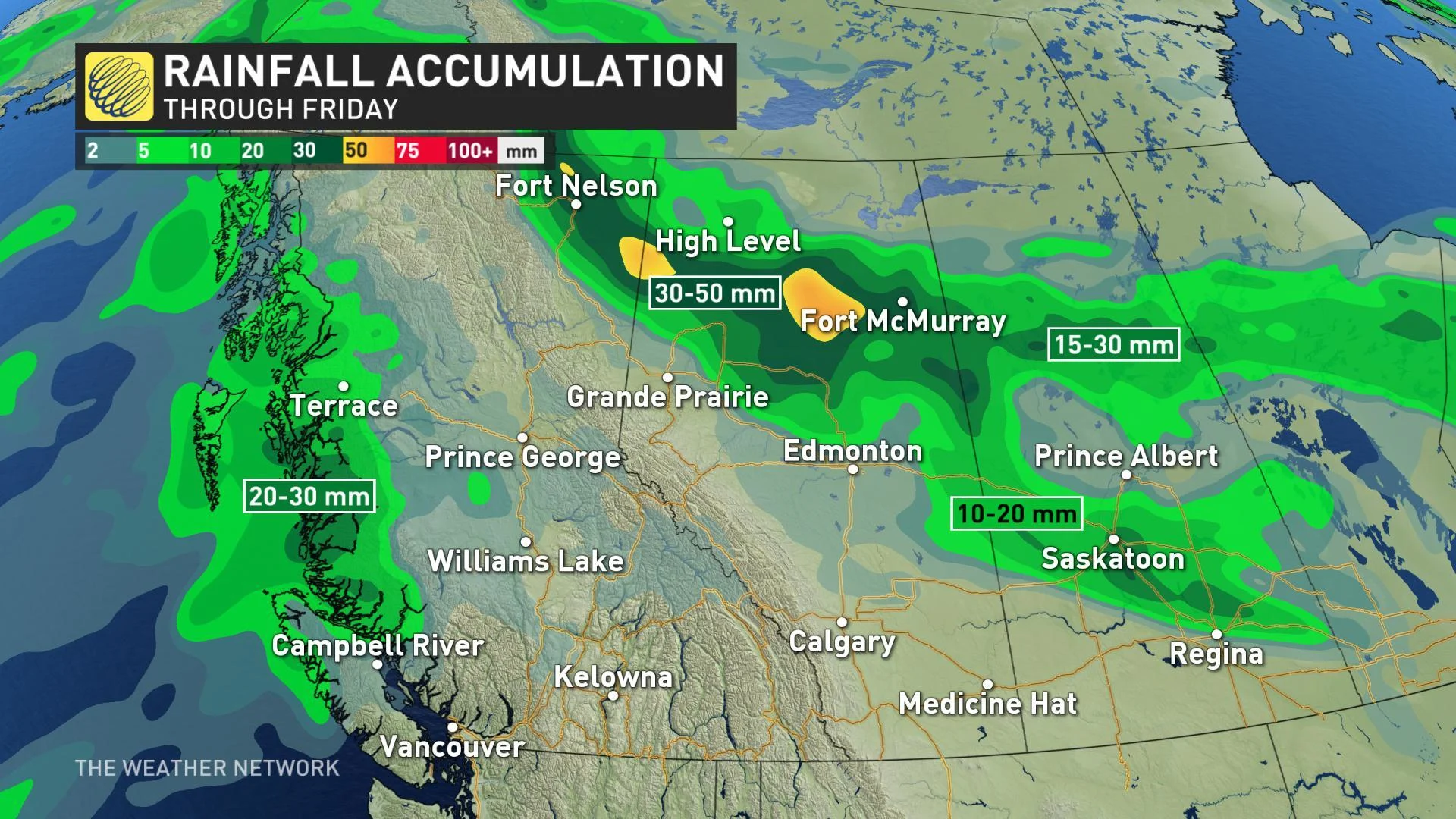
BENEFICIAL RAIN FOR SOME
On the north side of the low, rainfall warnings linger for parts of northwestern Alberta in an "extended period of heavy rain," with 30-50 mm expected to still fall through Friday. The real benefit to this large scale rainfall event will be the aid it provides to the ongoing fire situation in Alberta.
"If visibility is reduced while driving, turn on your lights and maintain a safe following distance," warns Environment Canada. "Watch for possible washouts near rivers, creeks and culverts."
STUBBORN STORM THREAT PERSISTS INTO THE WEEKEND
Yet another system will develop east of the Rockies on Friday night and is expected to track across the central and northern Prairies throughout the weekend. This will bring a widespread rain to areas especially north of the Yellowhead Highway, with the risk for thunderstorms and strong winds persisting as well.
"We'll see some hot weather in parts of southern Saskatchewan and Manitoba ahead of this system, but cooler conditions will spread across the region as the storm moves through," says meteorologist Dr. Doug Gillham, who adds that the cool start to next week will actually be followed by another warm-up by the mid-week mark.