Thunderstorm risk looms over Ontario ahead of coolest stretch since May

Another thunderstorm threat returns to southern Ontario for Wednesday, ahead of a major temperature tumble, which will leave things feeling more like early October.
With the last full day of summer on Wednesday, it could be perfectly timed with one of southern Ontario's final days to see widespread thunderstorms and the chance for some to turn severe. The autumn season will then kick into high gear for Thursday and beyond, as temperatures take a nosedive into early October territory for a few days. More on the Wednesday storm risk, timing and the October-like temperature tumble that follows, below.
Visit our Complete Guide to Fall 2022 for an in-depth look at the Fall Forecast, tips to plan for it and much more!
Wednesday and beyond: Storm threat could be Ontario's last, fall-like temperatures to follow late week
The muggy, mid-summer-like conditions will linger across most of southern Ontario through the middle of the week, with high temperatures in the mid-20s and humidex values cracking 30. It won’t last much longer, though.
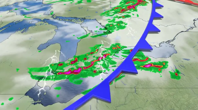
Wednesday could also be one of southern Ontario's final days of the storm season with a widespread risk of severe weather.

A potent, upper-level trough will have an associated surface low that will be tracking across the province Wednesday. The system's cold front will be the trigger for widespread thunderstorms across the region through the day.
Strong winds, hail and heavy rain would be the main threats with these storms.
We will continue to keep a close eye on the atmospheric dynamics for Wednesday.

RELATED: Why you can't rule out tornadoes during Ontario's cooler months
A trough swinging into the eastern half of the country will bring dramatic changes by Thursday. Toronto will see a feels-like value of 30 on Wednesday afternoon, but daytime highs are only expected to reach the upper teens by Thursday afternoon. This will be the coolest stretch across the region since the May long weekend.
Temperatures will only reach the lower teens across cottage country. Friday will also be the coldest day for Ottawa with a high in the low- to mid-teens.
There will also be a risk for waterspouts over the Great Lakes on Thursday, along with lake-effect showers downwind of the lakes and widespread frost outside of the urban areas -- especially north of the Greater Toronto Area (GTA) Thursday and Friday nights.

While Friday will be mostly sunny across the region, temperatures will be more typical of early October, especially across cottage country where frost is likely.
Cooler than seasonal temperatures are expected for the final week of September, as well, however, above seasonal temperatures are expected to return and dominate during the month of October.
WATCH: The polar vortex is waking up, what does this mean for Canada's winter?
Check back for the latest on conditions across Ontario.