Ontario: Chance of severe thunderstorms, scattered showers

The long weekend in southern Ontario could potentially close out with a few rumbles of thunder, especially in southwestern regions where there is a chance for severe thunderstorms. The rainy system that is approaching the region will also bring scattered showers to many that could last through Tuesday. Read below for details and timing.
Summer revealed! Visit our for an in-depth look at the Summer Forecast, tips to plan for it and much more
WEATHER HIGHLIGHTS:
Rainy system targets southern Ontario through Monday evening
Threat for more rain, thunderstorms Canada Day
Latest alerts for your area
WATCH BELOW: TIMING OF MONDAY'S RAIN
An approaching low pressure system is threatening showers for Monday, which could potentially interrupt plans for fireworks.
"Unfortunately, the timing for our next system continues to be faster with an increasing threat for showers and thunderstorms tracking from west to east during the afternoon and evening hours on Monday," says meteorologist Dr. Doug Gillham. "There's the potential for this to impact fireworks for the region, including into the Ottawa area as well."
The bulk of the thunderstorm energy associated with this system is expected to remain stateside throughout Monday evening, but the risks that could come with any thunderstorms that occur in southwestern Ontario include heavy rain and strong winds.
Temperatures will remain on the warm side throughout the evening, except for areas including Windsor and Chatham area where a heat warning is in effect. This is due to a hot, humid air mass tracking through the region and could cause maximum daytime temperatures to reach 31°C.
The scattered showers or thunderstorms that are expected on Tuesday could prevent maximum daytime highs from reaching 31°C, but humidex values are expected to be near 40.
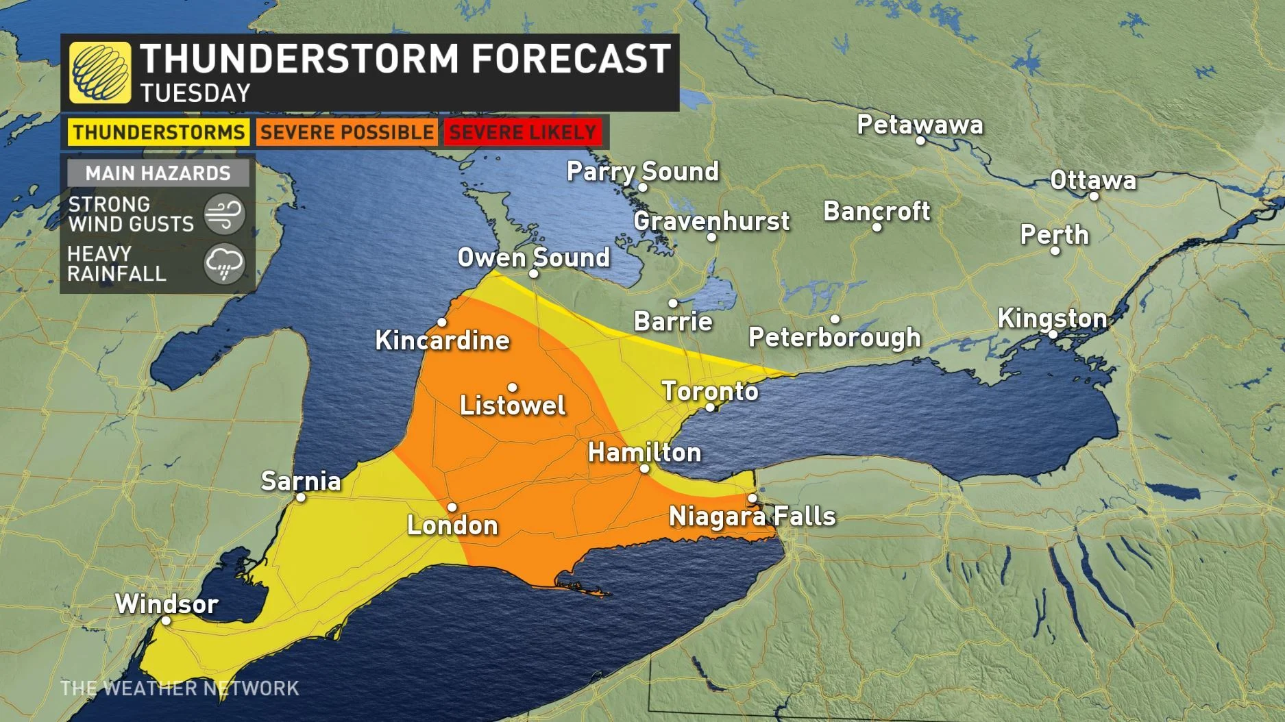
The risk for thunderstorms continues through Tuesday, and the chance for severe thunderstorms increases for southwestern regions of the provice and extends from Kincardine through to London and Niagara Falls.
EXTENDED HEAT FOR FIRST WEEK OF JULY
By next week, the extreme heat will catch up to the rest of the province in what could be the first extended period of hot and humid weather.
"This first prolonged period of heat will start on Tuesday and continue for the rest of the week and possibly into the weekend as well," says Gillham. "High temperatures will be in the upper 20s and lower 30s each day with a humidex reaching the upper 30s and possibly approaching 40."
The second half of next week, however, will also bring an increasing threat for thunderstorms at times.
By the second week of July, more seasonal conditions are expected to return, with a couple of days possibly ending up a few degrees cooler than normal.
"For the month as a whole, we expect near normal temperatures for July," Gillham says.