
Nova Scotians in high-risk areas asked to evacuate as Teddy nears

Environment Canada says that shorelines must be avoided due to dangerous conditions including localized flooding, coastal erosion in vulnerable areas and a rough surf.
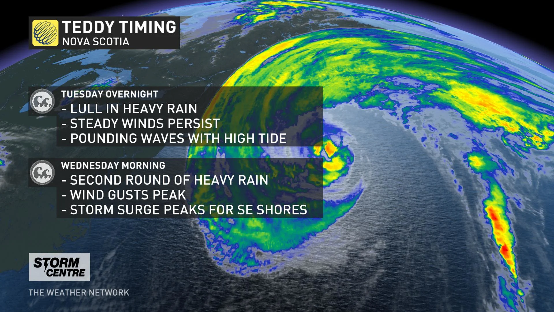
Teddy is now a post-tropical cyclone and is continuing its trek towards Nova Scotia. The storm will make landfall early on Wednesday and will bring heavy rain, damaging winds, and dangerous storm surge to the region. Read below for more details.
STORM CENTRE: EVERYTHING YOU NEED TO KNOW ABOUT TEDDY
ATLANTIC CANADA BRACING FOR IMPACTS
Teddy is considerably down from its Category 3 peak earlier in the week in the mid-Atlantic, sapped of much of its strength by the cooler ocean waters on its path toward Canada's East Coast. Teddy will arrive in Nova Scotia as a post-tropical cyclone sometime early Wednesday.
However, "post-tropical" refers only to the structure of the storm, which will still be a very strong event for the region and could feature tropical-storm-force winds. Its effects have already begun to be felt in Nova Scotia and will be ramping up in Newfoundland.
The Weather Network meteorologist Matt Grinter notes that some parts of Nova Scotia will see impacts that will be similar to those from Hurricane Dorian (2019).
“Dorian produced wind gusts of 101 km/h in Halifax and brought in 73.2 mm of rain. The highest model currently indicates 96 km/h for a maximum wind gust in Halifax, with most of the others in the 70-80 km/h range. Halifax will most likely end up with a gust in the 80-90 km/h range and rainfall very similar to Dorian,” Grinter explains.
RELATED: What is a hurricane storm surge, and why is it so dangerous?
The strongest winds will remain offshore, but the Atlantic coastal areas of Nova Scotia will still see some very strong gusts in the 80-100 km/h range, making them the equivalent of tropical storm-force.
SELF-EVACUATIONS IN NOVA SCOTIA
On Tuesday evening, the Halifax Regional Municipality asked people living in the Sambro area, Peggy's Cove and along the Eastern Shore to immediately make plans to self-evacuate ahead of Teddy's arrival.
“Citizens are encouraged to be in alternative locations prior to the arrival of the storm. Please contact the Emergency Operations Center at 902-490-3211 to self-register if you plan to self-evacuate for safety reasons,” says the Halifax Regional Municipality.
DANGEROUS CONDITIONS AS WIND GUSTS, RAIN INTENSIFY
Warnings are in effect ahead of those winds, which will peak through Tuesday evening. Even in places not in the warning, the rest of Nova Scotia, Prince Edward Island and the Magdalen Islands are still in line to see 70-80 km/h winds, with some gusts up to 90 km/h.
"Given trees are still in full leaf, these winds could cause limbs to break with isolated tree falls, likely leading to many power outages," Environment Canada warned in its latest tropical cyclone statement.
Mark Sidebottom, Nova Scotia Power's chief operating officer, told The Weather Network that Teddy’s track is being closely monitored and 300 crews are on standby across the province to respond to damages to the power grid.
High winds and rain have the potential to cause damages to trees, which could knock down power lines and cause widespread outages.
“The leaves [are] well-attached to the trees still at this time of year and the ground is not frozen, [so] it acts a bit like a sail and it makes trees more susceptible to being damaged,” Sidebottom explained.
Nova Scotia Power's online outage map provides information about power outages and restoration times.
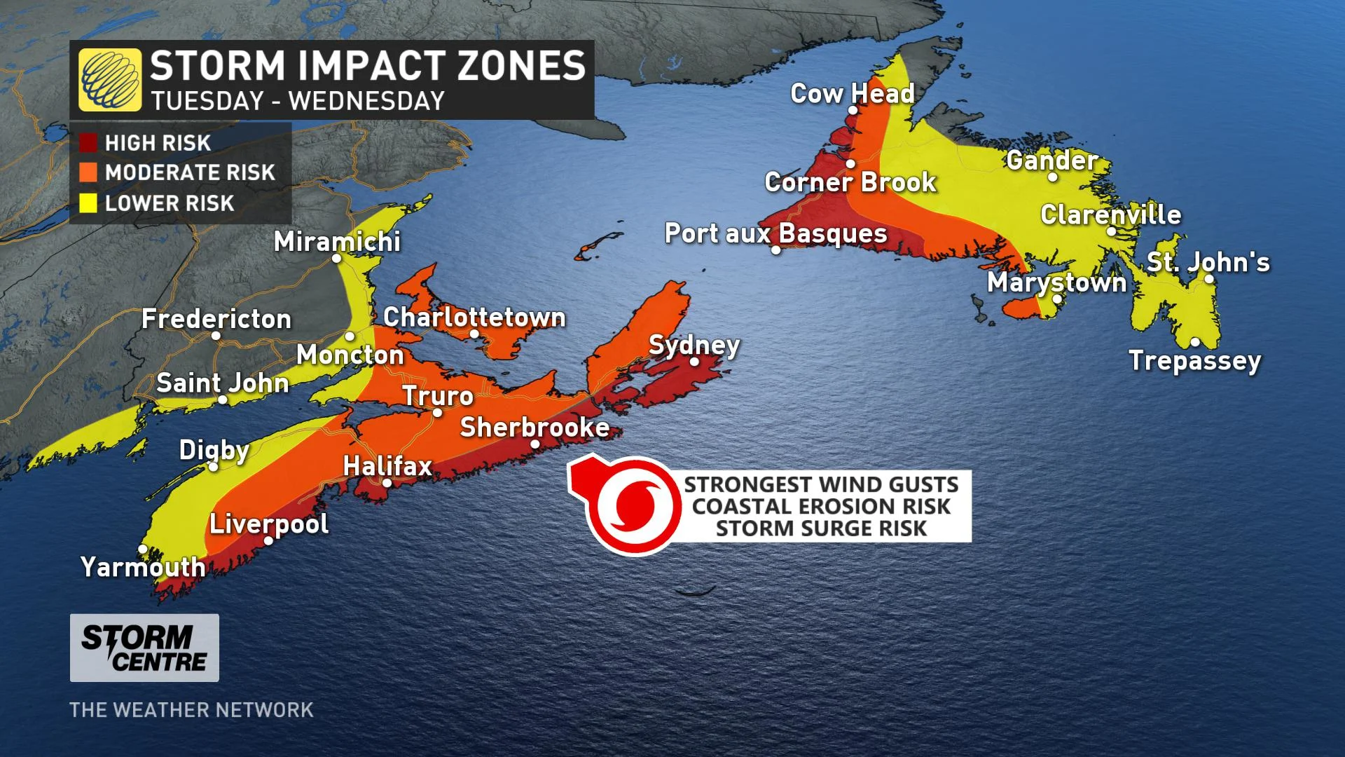
Waves at the shore won't be as tall as at sea, where they are expected to be as high as 30 metres in some areas, but they'll still be substantial: 8-10 metres off the Nova Scotia Atlantic coast, and 6-8 metres for parts of Newfoundland.
"The highest risk is the combination of the very large waves combining with the storm surge to cause dangerous conditions along the Atlantic coasts of Nova Scotia and Newfoundland," the Canadian Hurricane Centre says.
"Rough and pounding surf, localized flooding and coastal erosion are likely in vulnerable areas, even outside of the times of high tides. Stay away from the shore - the combination of surge and large waves could result in dangerous rip currents and the risk of being pulled out to sea."
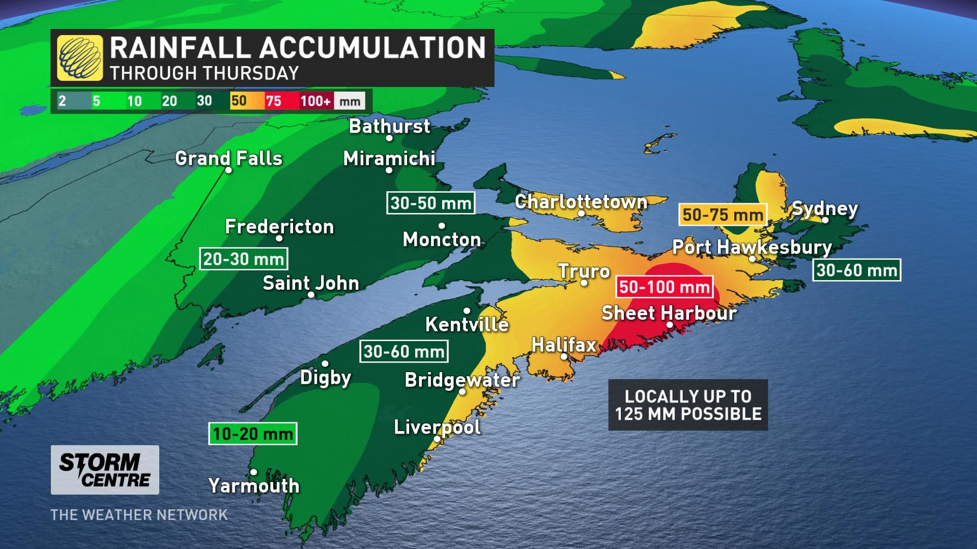
The highest amounts of rainfall will be just to the north and west of the storm's track through the region, so much of Nova Scotia and Prince Edward Island look to get 50-100 mm through Wednesday, and possibly as much as 125 mm in the worst-hit areas.
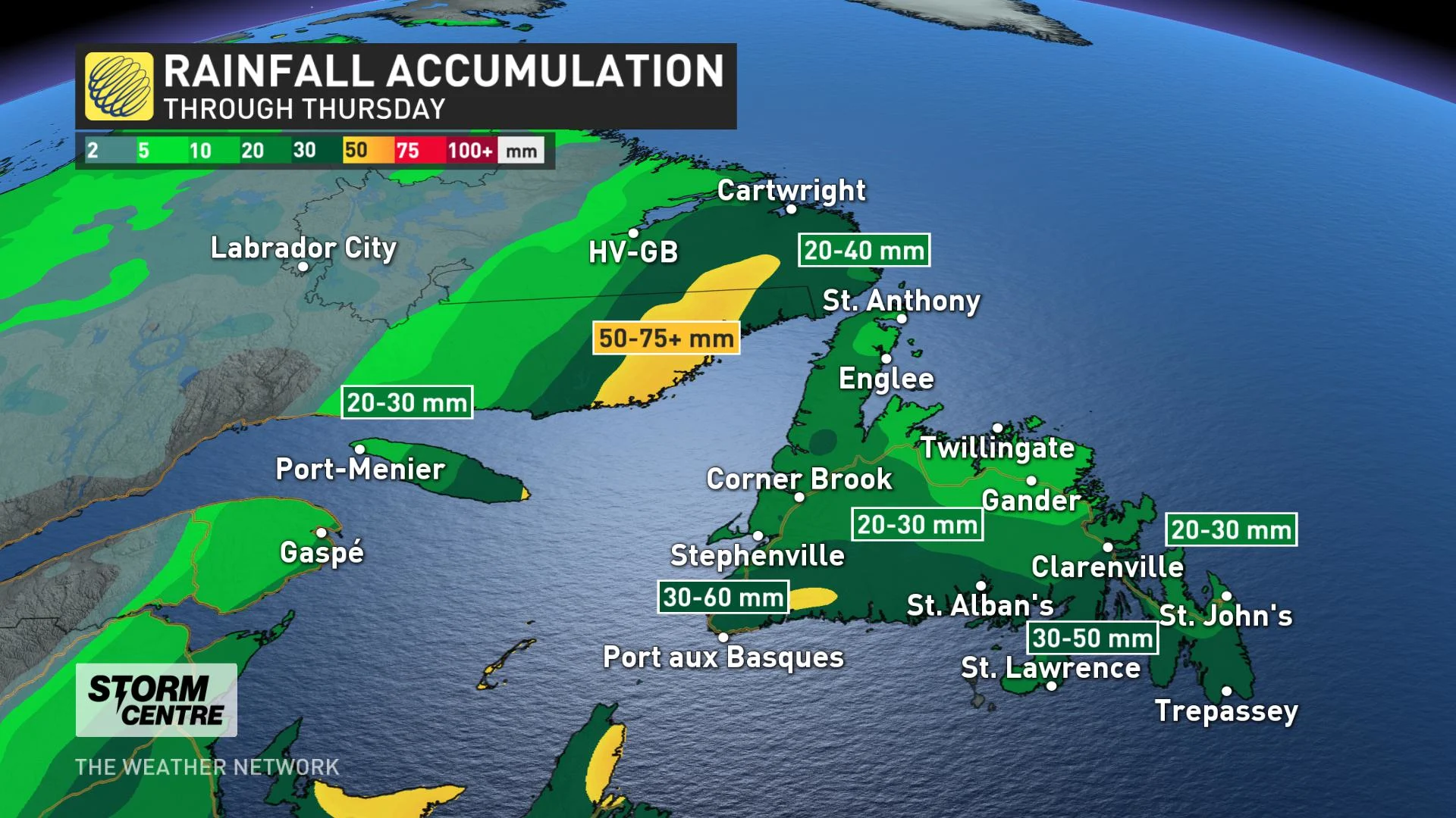
Across the Gulf, western Newfoundland will see the heaviest rainfall, possibly lasting into early Thursday morning. Between 30 to 50 mm will fall on the island over the course of this evening, but parts of Labrador may pick up higher amounts, possibly more than 75 mm.
RELATED: What you need in your hurricane preparedness kit
The last landfalling tropical system in Atlantic Canada was last year's Dorian, which made landfall in Nova Scotia as a Category 1-equivalent extratropical storm on September 7th, and later on made a second landfall in Newfoundland.
As the situation has the potential to be impactful, continue to check back for updates as we keep an eye on Teddy's movements.