
Drenching rains with potent storm elevates flood risk in Atlantic Canada

Eastern Canada is on the receiving end of a significant Texas low moving through this week. Rain will become heavy and widespread across the western Maritimes on Tuesday, with blustery wind gusts in the morning and afternoon. Portions of the Maritimes and Newfoundland could see up to 100 mm of rain from this slow-moving system. The risk for flooding has been raised as a result. Newfoundland will begin seeing the rain push in Wednesday afternoon. Meanwhile, parts of Labrador will bear the brunt of the heaviest snow once again, accompanied by a threat for a prolonged period of freezing rain and ice pellets. Details and timing, below.
Visit our Complete Guide to Winter 2021 for an in depth look at the Winter Forecast, Canada's ski season, and tips to plan for everything ahead!
WEATHER HIGHLIGHTS
Rain becomes widespread in the Maritimes Tuesday
Winds will be strongest Tuesday morning, with 60-90 km/h gusts in Maritimes
Precipitation reaches Newfoundland Wednesday afternoon
Heavy snow, prolonged freezing rain, ice pellets in Labrador
TUESDAY THROUGH WEDNESDAY: SOAKING RAINS, STRONG WINDS, HEAVY LABRADOR SNOW
Tuesday will be a soggy and blustery day across the Maritimes, with the heaviest of the rains pushing through in the morning, becoming widespread through the day.
Due to the near stationary nature of the system, rain will linger in the Maritimes until Wednesday afternoon. By the time it departs, sustantial amounts are expected to accumulate in parts of the region.
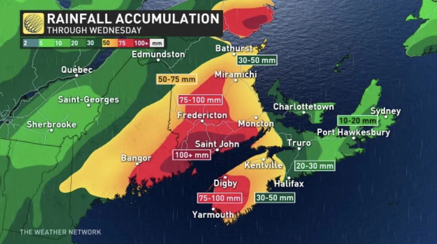
The heaviest rain will fall over cental and southern New Brunswick, as well as southwestern Nova Scotia, where 75-100 mm is expected. Central areas of the latter and western areas of the former may pick up 30-50 mm.
“Flash flooding and localized flooding are a near certainty,” warns Weather Network meteorologist Tyler Hamilton.
Meanwhile, Newfoundland will be dry Tuesday and won't begin to see the impacts of the low until Wednesday afternoon, with precipitation manifesting as rain for the island. Rainfall amounts will also be considerable for portions of the province, with the heaviest expected in southwestern sections. Parts of this region could see 75-100 mm by the time the system pushes out Thursday.
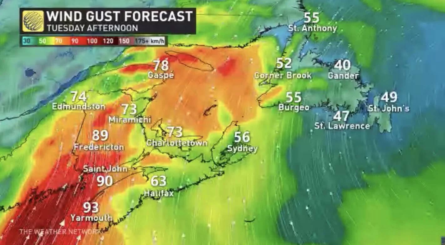
Winds will be quite blustery Tuesday across the Maritimes, though strongest in the morning hours. Gusts of 70-80 km/h are expected in New Brunswick, P.E.I, and southern Nova Scotia. They may even exceed 90 km/h in extreme southern portions of New Brunswick and southwestern Nova Scotia.
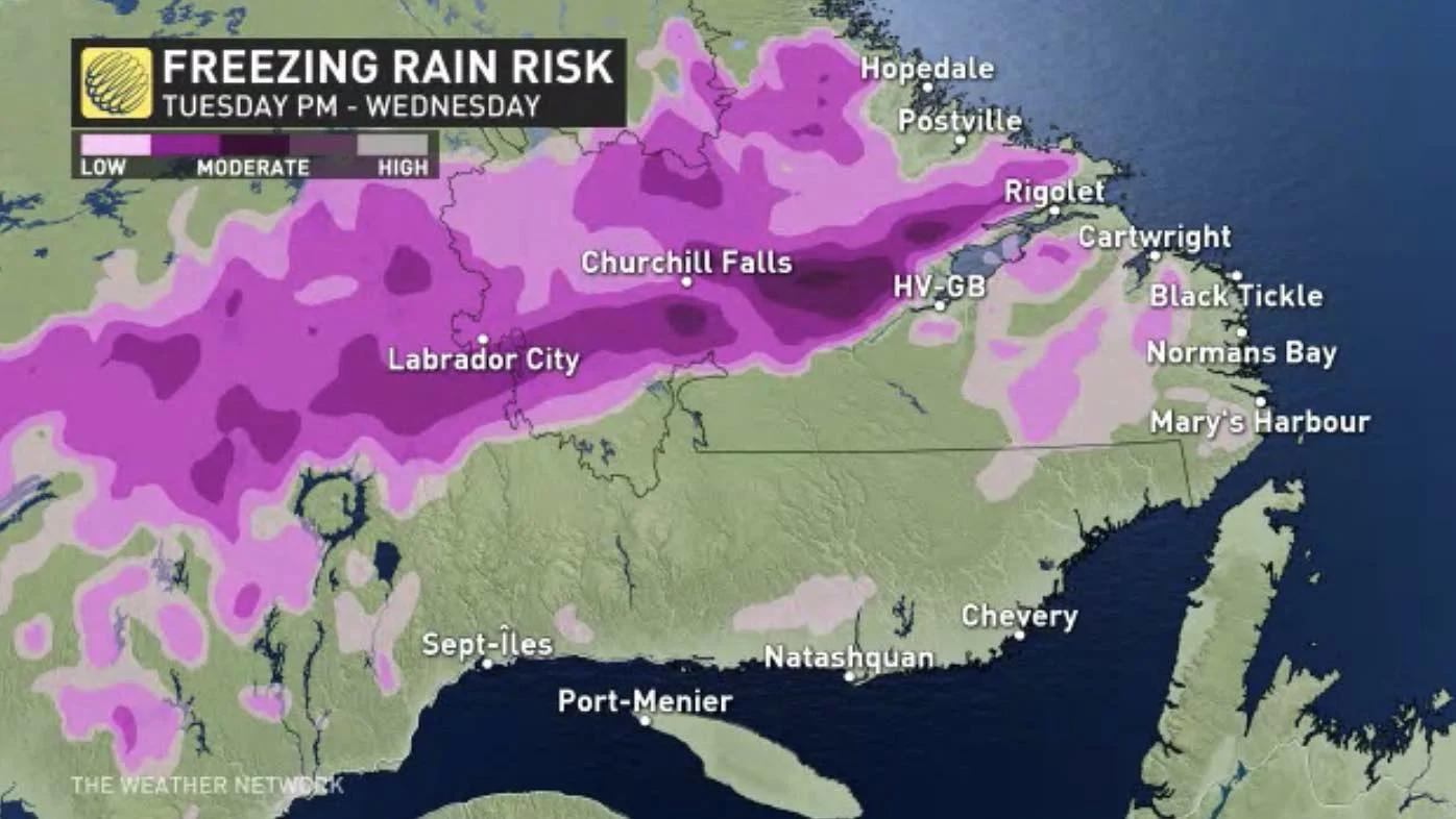
THREAT FOR HEAVY SNOW, FREEZING RAIN, ICE PELLETS IN LABRADOR
Most of Atlantic Canada will see just rain from the low, with mild temperatures, but Labrador is in line to get a hefty shot of snow and possibly 8-12 hours of freezing rain. Snowfall, winter storm and freezing rain warnings are in effect.
Snow will become heavy at times into early Tuesday morning, transitioning to rain in the afternoon before switching to a prolonged period of freezing rain in the overnight hours. Precipitation will then change back to rain Wednesday afternoon as temperatures rise above the freezing mark.
Further west through Churchill Falls, Labrador City, and Wabush, periods of snow are expected to continue through Tuesday night with an extended, and potentially significant, period of ice pellets and freezing rain likely on Wednesday.
Snowfall amounts may reach 40-50 cm by the time the system departs.
"Surfaces such as highways, roads, walkways and parking lots may become icy and slippery. Be prepared to adjust your driving with changing road conditions," Environment Canada warns.
Temperatures will trend cooler in the Maritimes behind the low on Wednesday, but the warmth will hang on in Newfoundland into Thursday.
Beyond, it won't be as warm as early in the week, but still above seasonal late-week and on the weekend. There is also the potential for a more active pattern early next week.
Check back as we continue to monitor the approach of these systems.


