Ontario: Watches, warnings issued as storms blossom

Muggy conditions have left the atmosphere primed for thunderstorms Wednesday afternoon, and strong cells have started to blossom over southwestern Ontario. Environment Canada has issued watches and warnings for parts of the province as storms begin their march across the region. We break down the timing for storms, and a look at tumbling temperatures that await for the remainder of the week, below.
WEATHER HIGHLIGHTS
Thunderstorm threat into afternoon, heavy downpours possible
Second half of the week will be less humid, feeling more like late fall
See-saw temperatures and changeable conditions round out August
Stay up to date on ALERTS in your area
WATCH BELOW: TRACKING THE THUNDERSTORM ENERGY
MORE WIDESPREAD THREAT THROUGH WEDNESDAY
Thunderstorms started to push into southwestern Ontario late Wednesday afternoon in what looks to be a rainy, rumbly evening across southwestern Ontario, Niagara, and parts of the Golden Horseshoe.
Further east, isolated storms also dot central and eastern Ontario well ahead of a cold front expected to sweep through during the overnight hours.
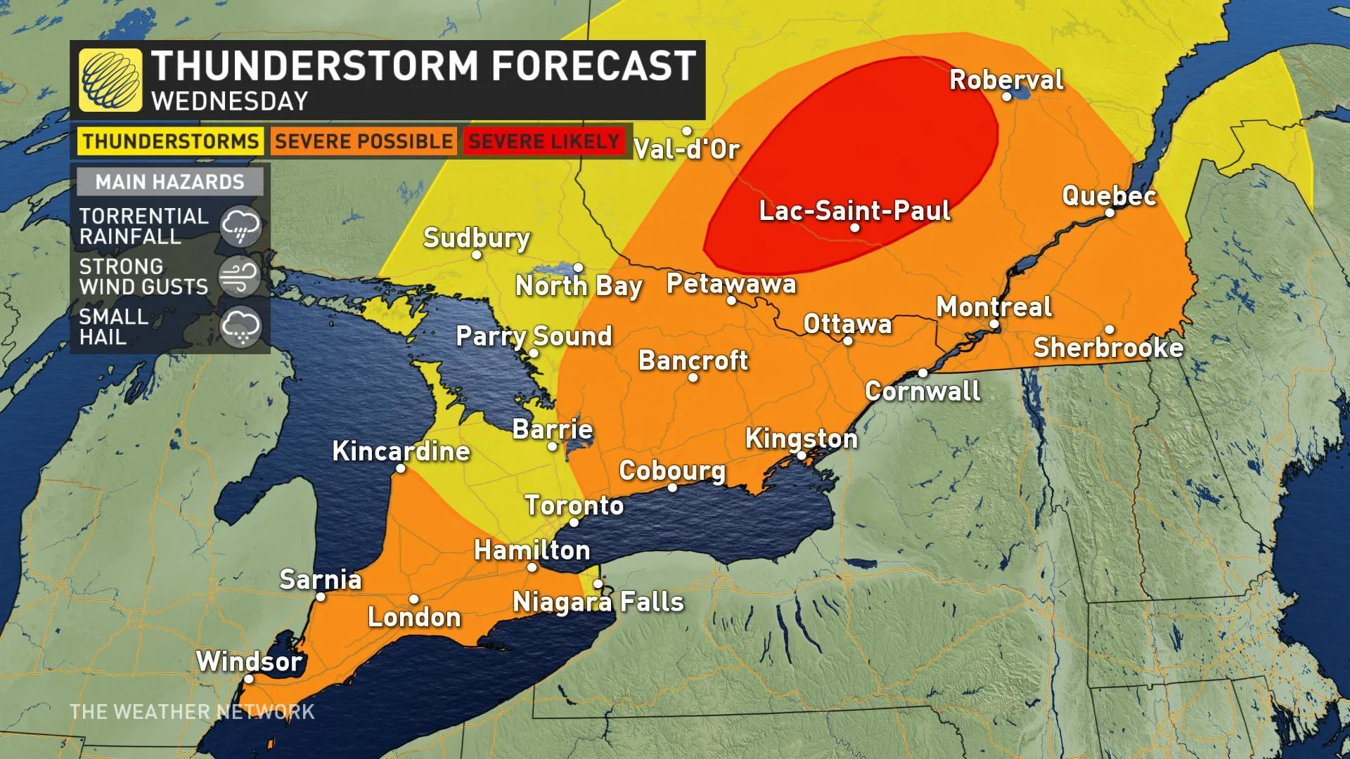
Heavy downpours and strong wind gusts are expected to be the main risk with storm cells cutting through the southwest, although small hail isn't out of the question with some of the more potent cells. Multiple rounds of storms are also possible as cells drift in from Michigan; even once storms pass you'll want to stay weather-aware along the shores of Lake Huron and into extreme southwestern Ontario.
Expect storms to cross the 401 corridor through the evening hours, ultimately bringing heavy rain and rumbles of thunder to parts of the Golden Horseshoe after sunset, with isolated cells likely to drift through Niagara, Toronto, and the eastern GTA by midnight.
Once the front tracks through and the winds change, we'll see a better chance for showers across southwestern Ontario, from Windsor to the shores of Lake Huron, and toward the Golden Horseshoe Wednesday afternoon and evening.
TEMPERATURES TUMBLE LATE WEEK
The cold front associated with Wednesday's storms will send temperatures tumbling to some of the coolest weather we've seen since early June by Thursday and Friday. High temperatures on both days will only reach the lower 20s, with daytime highs in the upper teens expected for parts of cottage country.
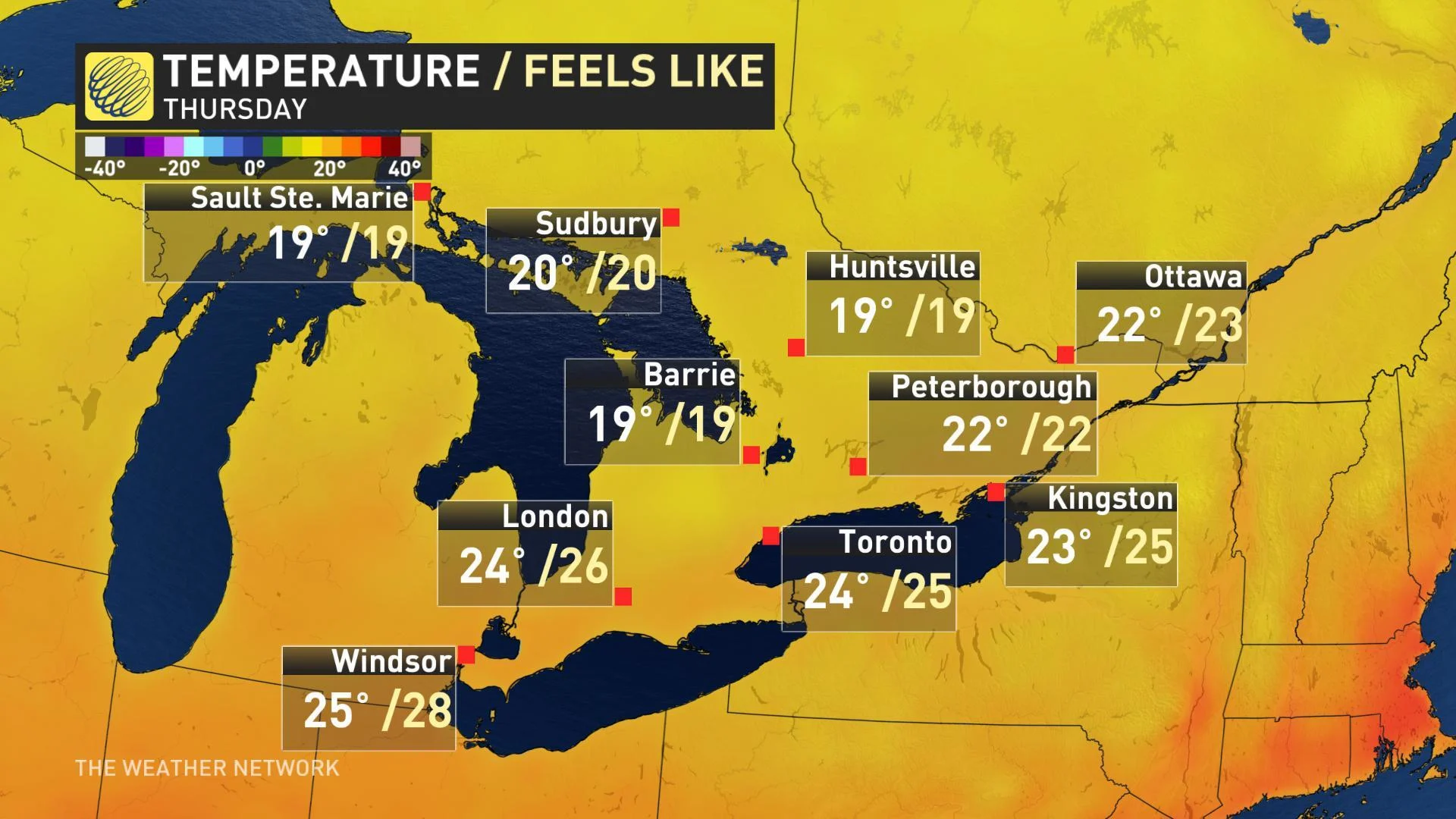
Expect more of the same through the weekend as temperatures stay on the cool side of seasonal, although abundant sunshine will make for some gorgeous late summer weather.
"Overnight low temperatures will be rather chilly, especially across cottage country (widespread single digits) and daytime highs will be in the low to mid-20s," adds Weather Network meteorologist Dr. Doug Gillham.
Any sort of last blast of summer heat will really struggle to lock in through the end of August with another shot of cooler air expected to flood in for the second half of next week as well.
MUST READ: How twin typhoons MAJORLY complicate summer's end in Canada
"Next week also has the potential to bring a few days of active and unsettled weather as southern Ontario will be the battle zone between hot and humid weather to our south and cooler air from the north that will be pushing south into the Great Lakes region," Gillham adds.


