
Avalanche threat drops in B.C. but the next snowfall may raise risk

The usual soggy pattern B.C. will back off Tuesday, but another round of coastal rain and alpine snow is headed for the coast Wednesday.
After a soaking weekend and start to the week in B.C., the copious rainfall and mountain snow will begin to diminish in the overnight hours Monday, with precipitation becoming scattered and lighter in nature Tuesday. Winter storm and snowfall warnings remain in place for some of the mountain passes, but are expected to be dropped through the overnight. However, a 'moderate' avalanche danger rating will continue for most of the region Tuesday from the recent additions to the snowpack. Beyond, a strong storm will track into the central coast of B.C. Wednesday night with rain and alpine snow spreading south. There may even be some low-elevation snow. More details and timing, below.
WEATHER HIGHLIGHTS
Rainfall, heavy snow in mountain passes eases Monday night, conditions begin to improve Tuesday
More seasonal, milder temperatures in the system's wake
Widespread 'moderate' avalanche danger with heavy snow and winds
TUESDAY: RAIN, SNOW WINDS DOWN, BECOMES SCATTERED
A significant push of Pacific moisture that led to heavy rainfall on the weekend, will gradually ease off for Vancouver Island and the Lower Mainland through Monday overnight, lingering through the day Tuesday, but will be quite scattered in nature.
Accumulatively, parts of western Vancouver Island were forecast to see between 75-100+ mm of rain from this event, with 20-30 mm for Metro Vancouver, and slightly higher amounts further inland for the Lower Mainland.

The significant plumes of moisture have also manifested as snow at the higher elevations. Snow levels will drop to 700 metres Tuesday after sitting at 1,200 metres Monday. Winter storm warnings are in place still, but should be dropped through the overnight as snow is forecast to taper off to a few scattered flurries Tuesday morning. Total accumulations may exceed 30 cm by the time it diminishes.
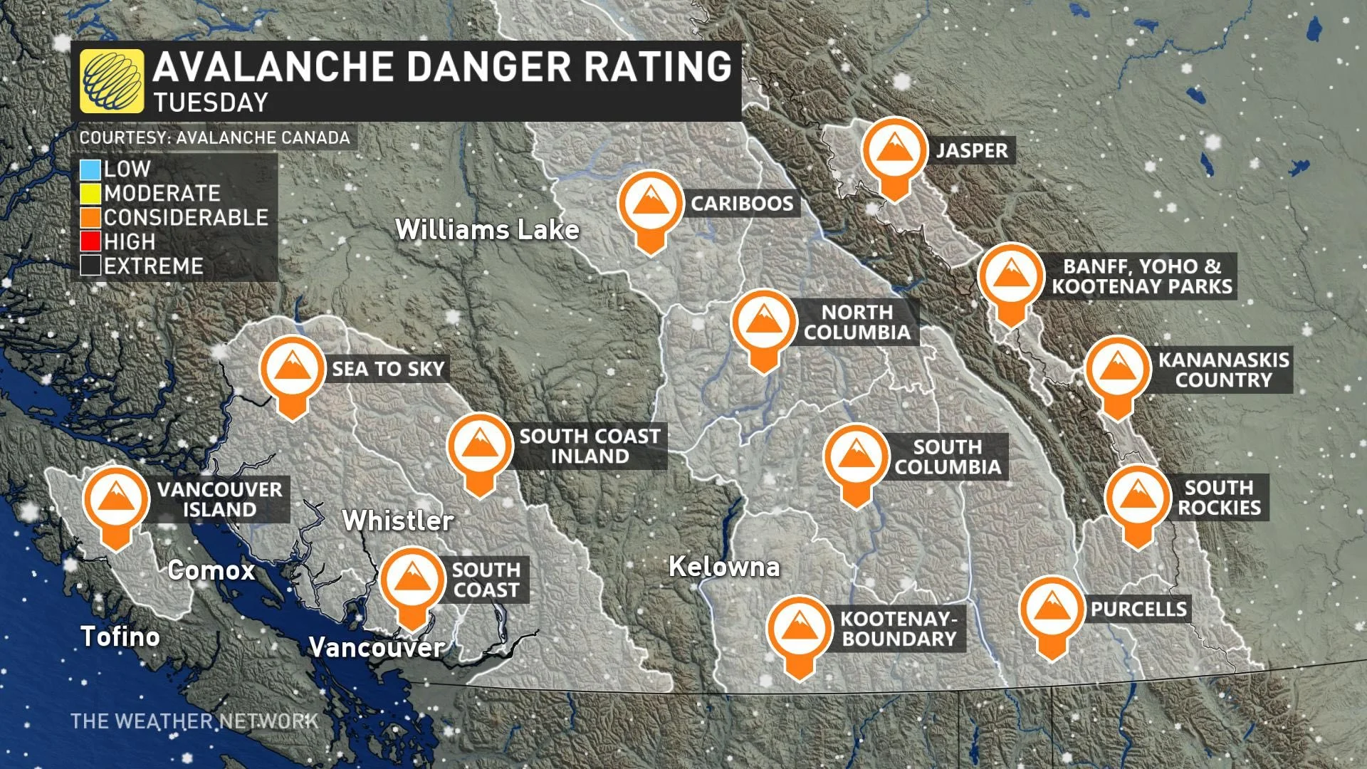
The avalanche danger rating is expected to remain 'moderate' across much of the mountain region Tuesday after the recent hefty snowfall totals add to the snowpack.
"As we head into a couple days of friendlier weather, resist the allure of bigger terrain and be especially wary of recently wind-loaded features. Recent storm snow sits on a thick layer of weak, sugary facets and bonding at this interface may take some time," officials with Avalanche Canada warn.
BEYOND: UNSETTLED PATTERN CONTINUES, LOW-ELEVATION SNOW POSSIBLE WEDNESDAY
Beyond Tuesday, low-elevation snow is possible Wednesday night into early Thursday morning for the South Coast. A strong storm will track into the central coast of B.C. with rain and alpine snow spreading south.

Surface temperatures across the Lower Mainland will remain above freezing, so precipitation will be primarily rain, but there is the possibility of a rain/snow mix. However, temperatures aloft will be cold enough for a period of accumulating wet snow across the higher terrain.
Significant snow is expected for the North Shore ski areas and also for the southern and central Rockies, as well as the B.C. Peace region.
By the weekend, some quieter weather is likely, though with eyes on a potential system for Sunday, which would most likely bring rain for coastal areas.
Thumbnail courtesy of Alouette Parks.
Check back as we continue to monitor the unsettled pattern across B.C.