Wednesday, January 26th 2022, 10:30 am - An intense snow squall off of Lake Ontario created locally heavy accumulations and dangerous whiteout conditions Wednesday morning.
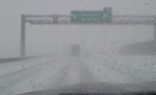
Winter weather travel advisories were issued across Huron County early Wednesday morning, as locally heavy snow squalls made for difficult travel and whiteout conditions along the QEW corridor.
Squalls, more commonly known as lake-effect snow, occur as cold air sweeps in over the ice-free Great Lakes in parts of early winter or late fall. The cold, dry air "picks up" moisture from the relatively warm lakes, continues over the land and dumps the moisture as snow.
Snow squalls are a part of winter life in southern Ontario, but they are also notoriously difficult to forecast for.
Whiteout#ONstorm #QEW pic.twitter.com/wn6TqUBWhO
WhiteoutNigel Hay on Twitter: "Whiteout#ONstorm #QEW pic.twitter.com/wn6TqUBWhO / Twitter" Nigel Hay on Twitter: "Whiteout#ONstorm #QEW pic.twitter.com/wn6TqUBWhO / Twitter" Nigel Hay on Twitter: "Whiteout#ONstorm #QEW pic.twitter.com/wn6TqUBWhO / Twitter"
— Nigel Hay (@LakeErieVlogger) Nigel Hay on Twitter: "Whiteout#ONstorm #QEW pic.twitter.com/wn6TqUBWhO / Twitter"
On Wednesday morning, frigid easterly winds poured across Lake Ontario.
"The majority of the band remained offshore, where it would have had minimal impact, but a small swirl in the flow developed near the west of the lake, which sent the band arcing southwards and directly into northern parts of the Niagara Peninsula," explains Michael Carter a meteorologist at The Weather Network.
This brought periods of localized whiteout conditions to places like Grimsby, and extremely hazardous and rapidly changing conditions to parts of the QEW corridor.
Surface observations and high resolution models are picking up on a mesoscale circulation at the west end of Lake Ontario. This swirl is what's helping to curve a band of heavy lake effect snow squalls into the QEW corridor, causing localized whiteout conditions. #ONStorm pic.twitter.com/l2qbHuS6gL
Surface observations and high resolution models are picking up on a mesoscale circulation at the west end of Lake Ontario. This swirl is what’s helping to curve a band of heavy lake effect snow squalls into the QEW corridor, causing localized whiteout conditions. Michael Carter ❄️ on Twitter: "Surface observations and high resolution models are picking up on a mesoscale circulation at the west end of Lake Ontario. This swirl is what's helping to curve a band of heavy lake effect snow squalls into the QEW corridor, causing localized whiteout conditions. #ONStorm pic.twitter.com/l2qbHuS6gL / Twitter" Michael Carter ❄️ on Twitter: "Surface observations and high resolution models are picking up on a mesoscale circulation at the west end of Lake Ontario. This swirl is what's helping to curve a band of heavy lake effect snow squalls into the QEW corridor, causing localized whiteout conditions. #ONStorm pic.twitter.com/l2qbHuS6gL / Twitter"
— Michael Carter ❄️ (@MichaelCarterWx) Michael Carter ❄️ on Twitter: "Surface observations and high resolution models are picking up on a mesoscale circulation at the west end of Lake Ontario. This swirl is what's helping to curve a band of heavy lake effect snow squalls into the QEW corridor, causing localized whiteout conditions. #ONStorm pic.twitter.com/l2qbHuS6gL / Twitter"
MUST SEE: Why snow squalls are one of the hardest events to forecast
As a more dominant southwest flow develops throughout the day, the band may drift north and impact areas along the western edge of Lake Ontario and then along the northern shoreline as well. Areas such as Hamilton, east through Toronto, may see parts of the snow squall nudge in during the early afternoon hours.
While the squall will likely break apart at this point, if snow does make its way into Toronto, it may continue to drift even further east through parts of the GTA later in the day.
THE POWER OF THE 'SNOW SNAKE'
Mesmerizing lake-effect band developing this morning. The snow snake returns! #ONStorm pic.twitter.com/JnOluKLUbW
Mesmerizing lake-effect band developing this morning. The snow snake returns! Tyler Hamilton on Twitter: "Mesmerizing lake-effect band developing this morning. The snow snake returns! #ONStorm pic.twitter.com/JnOluKLUbW / Twitter" Tyler Hamilton on Twitter: "Mesmerizing lake-effect band developing this morning. The snow snake returns! #ONStorm pic.twitter.com/JnOluKLUbW / Twitter"
— Tyler Hamilton (@50ShadesofVan) Tyler Hamilton on Twitter: "Mesmerizing lake-effect band developing this morning. The snow snake returns! #ONStorm pic.twitter.com/JnOluKLUbW / Twitter"
Snow globe mode activated in Grimsby this morning ☃️❄️ #ONStorm @weathernetwork #ShareYourWeather pic.twitter.com/JSWJa6LHi6
Snow globe mode activated in Grimsby this morning ☃️❄️ Katie Jones on Twitter: "Snow globe mode activated in Grimsby this morning ☃️❄️ #ONStorm @weathernetwork #ShareYourWeather pic.twitter.com/JSWJa6LHi6 / Twitter" Katie Jones on Twitter: "Snow globe mode activated in Grimsby this morning ☃️❄️ #ONStorm @weathernetwork #ShareYourWeather pic.twitter.com/JSWJa6LHi6 / Twitter" Katie Jones on Twitter: "Snow globe mode activated in Grimsby this morning ☃️❄️ #ONStorm @weathernetwork #ShareYourWeather pic.twitter.com/JSWJa6LHi6 / Twitter" Katie Jones on Twitter: "Snow globe mode activated in Grimsby this morning ☃️❄️ #ONStorm @weathernetwork #ShareYourWeather pic.twitter.com/JSWJa6LHi6 / Twitter"
— Katie Jones (@JatieKones) Katie Jones on Twitter: "Snow globe mode activated in Grimsby this morning ☃️❄️ #ONStorm @weathernetwork #ShareYourWeather pic.twitter.com/JSWJa6LHi6 / Twitter"
grimsbyon #ONStorm pic.twitter.com/BUYjrst1KZ
Corey Elder on Twitter: "#grimsbyon #ONStorm pic.twitter.com/BUYjrst1KZ / Twitter" Corey Elder on Twitter: "#grimsbyon #ONStorm pic.twitter.com/BUYjrst1KZ / Twitter" Corey Elder on Twitter: "#grimsbyon #ONStorm pic.twitter.com/BUYjrst1KZ / Twitter"
— Corey Elder (@coreywxelder) Corey Elder on Twitter: "#grimsbyon #ONStorm pic.twitter.com/BUYjrst1KZ / Twitter"
Another reinforcing shot of frigid weather is expected on Friday and Saturday across the region, though with abundant sunshine expected to splash through much of southern Ontario.
Next week will start out cold as well before turning milder through the mid-week mark, with a milder pattern attempting to return for the second week of February as well.
THE POWER OF A SNOW SQUALL: HOW HEAVY SNOW CAN UNLOAD ON SUCH A NARROW STRETCH
Thumbnail image courtesy: Nigel Hay