
After strong storm, traffic chaos, where to expect Tuesday's snow

The ordeal will be over for most people, but the traditional snowbelt region will be slammed with lake-effect snow Tuesday.
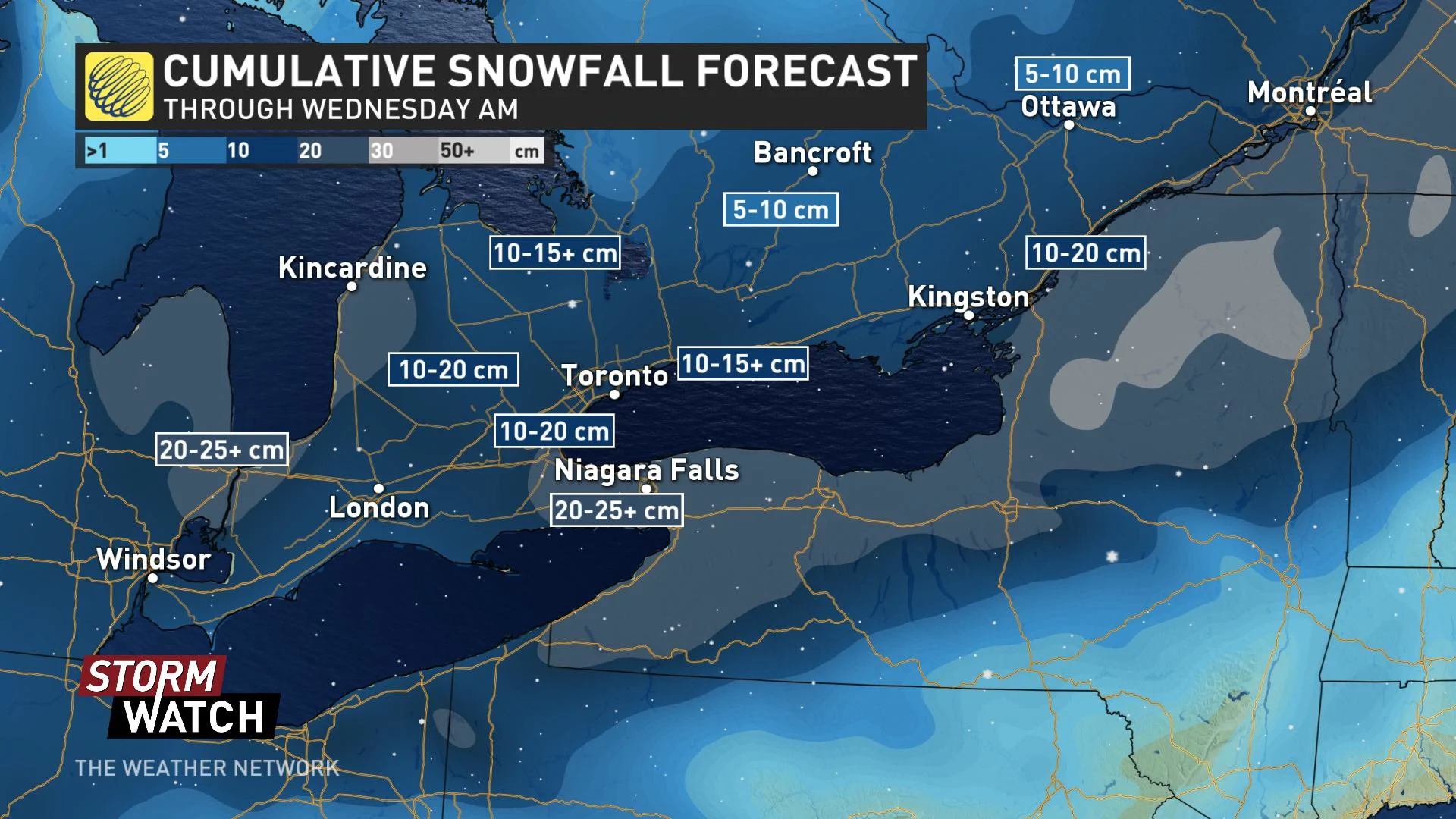
Southern Ontario will wake up on Tuesday having gone through a full-fledged winter storm event marked by a chaotic standstill on the busiest highways in the country for the evening commute the day before. Though digging out will be a challenge, and it will be largely over for most people Tuesday morning, people on or near the shores of Lake Huron and Georgian Bay will be at risk of at-times intense lake-effect streamers extending their ordeal for another day. All this amidst some very cold temperatures made worse by the winds. what to expect, below.
Severe weather warnings: Stay up-to-date, HERE
Time to prepare for the season ahead! The Weather Network's Winter Forecast launches Monday, November 18.
WHEN TO EXPECT THE SQUALLS
For most of the south of Ontario, a snowy overnight will give way to a calmer Tuesday, with the commute not being affected by snowflakes in all but the most eastern areas.
However, behind the system will be somewhat gusty winds which, aside from making temperatures feel even colder (more on that below), will fire up the lake-effect snow machine on Lake Huron and Georgian Bay.
The cold winds blowing over the still relatively warm lakes will make for intense snow squalls for the traditional snow-belt areas, such in areas near London and Collingwood. The squalls will move from south to north when the winds shift to the northwest later Tuesday night. By the time all is said and done, the squalls will have seriously ramped up snow totals already high from the departed system.
QUEBEC FACING A SNOWY TUESDAY
Though the heaviest snowfall will have peaked overnight, much of Quebec will still see snow persist through the day on Tuesday as it reaches eastern sections of the province.
Tuesday morning's commute will be especially difficult for southern and central Quebec, with reduced visibility expected in heavy, accumulating snow. The back edge of the snow pulls east of Montreal through late Tuesday morning, but continues across the Eastern Townships and Quebec City through the afternoon.
WATCH BELOW: HOW YOUR TUESDAY IS SHAPING UP IN QUEBEC
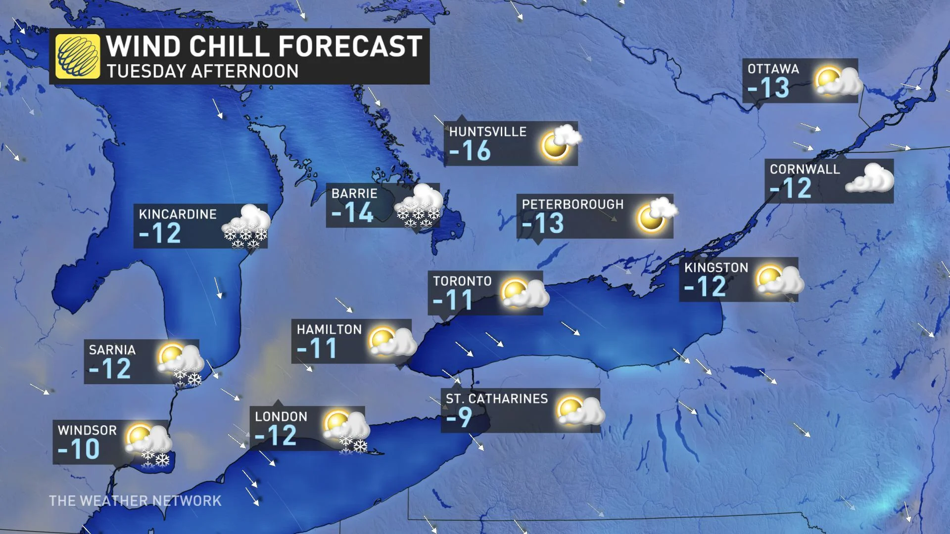
RECORD-BREAKING COLD WEATHER THROUGH WEDNESDAY
Although the snow will ease through the day on Tuesday, a gusty northwest wind will keep temperatures well below freezing into Wednesday.
"Overnight temperatures will reach the minus teens across most of southern Ontario, shattering the low-temperature records for this time of year," Gillham says.
An Alberta clipper will also track across the region Wednesday night and into Thursday morning with a few additional centimetres of snow expected.
Temperatures will recover somewhat Thursday and into Friday -- though still colder than seasonal -- but with another quick blast of arctic air arriving late Friday night.
"We'll see a very chilly weekend, especially for eastern Ontario and southern Quebec before temperatures recover back to near seasonal for most of next week," Gillham adds.