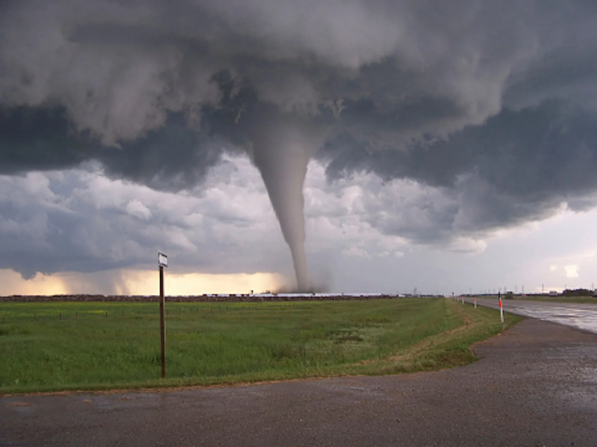
Why the famous 'Tornado Alley' is on the move
For years we have known that natural climate variability events like El Niño and La Niña have influenced tornado activity in the U.S., but now we also know that over the past 40 years, world famous 'Tornado Alley' has migrated eastward about 800 km.
Thirty years ago, tornado activity was especially high across the Great Plains -- anywhere from Texas north into the Dakotas. Tornado Alley, as many refer to this long swath of flat terrain, is the meeting point for warm tropical Gulf of Mexico air masses, and cooler drier air moving in from the north and west. It is a corridor where developing thunderstorms can grow severe enough to spawn tornados of all sizes and intensities.
Related: Tornado 101 - what you need to know about staying safe
For the past four decades, though, a new trend has been emerging in the data.
Researchers from Purdue University found that, for tornado activity between 1954 and 2013, a new maximum center for tornadic storms can be found in the Deep South -- the rise of the so-called "Dixie Alley."
The study showed that while annual counts and the overall number of days with tornadoes in the central Plains were on a downward trend, the overall number of tornadoes reported annually in the country was about level. How? Because of a sustained increase in tornadoes in the Southeast.
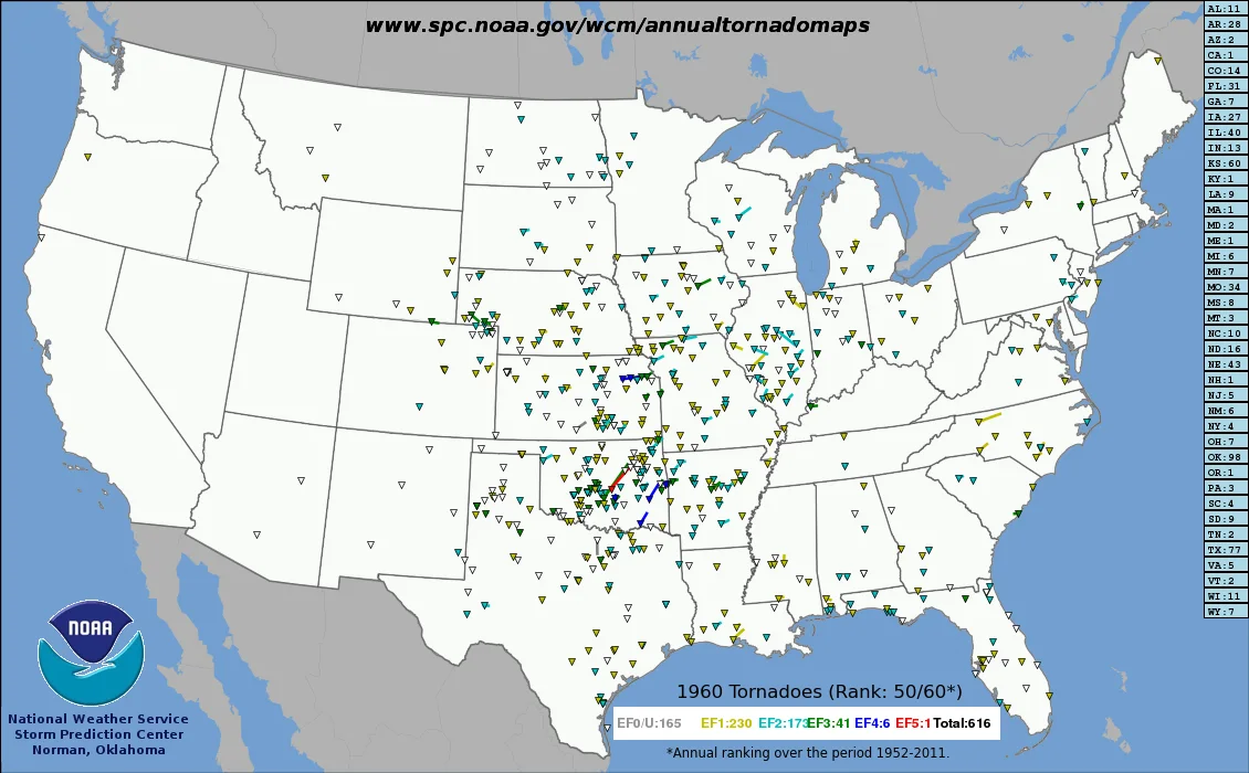
Tornado tracks as reported in 1960. Image courtesy NOAA.
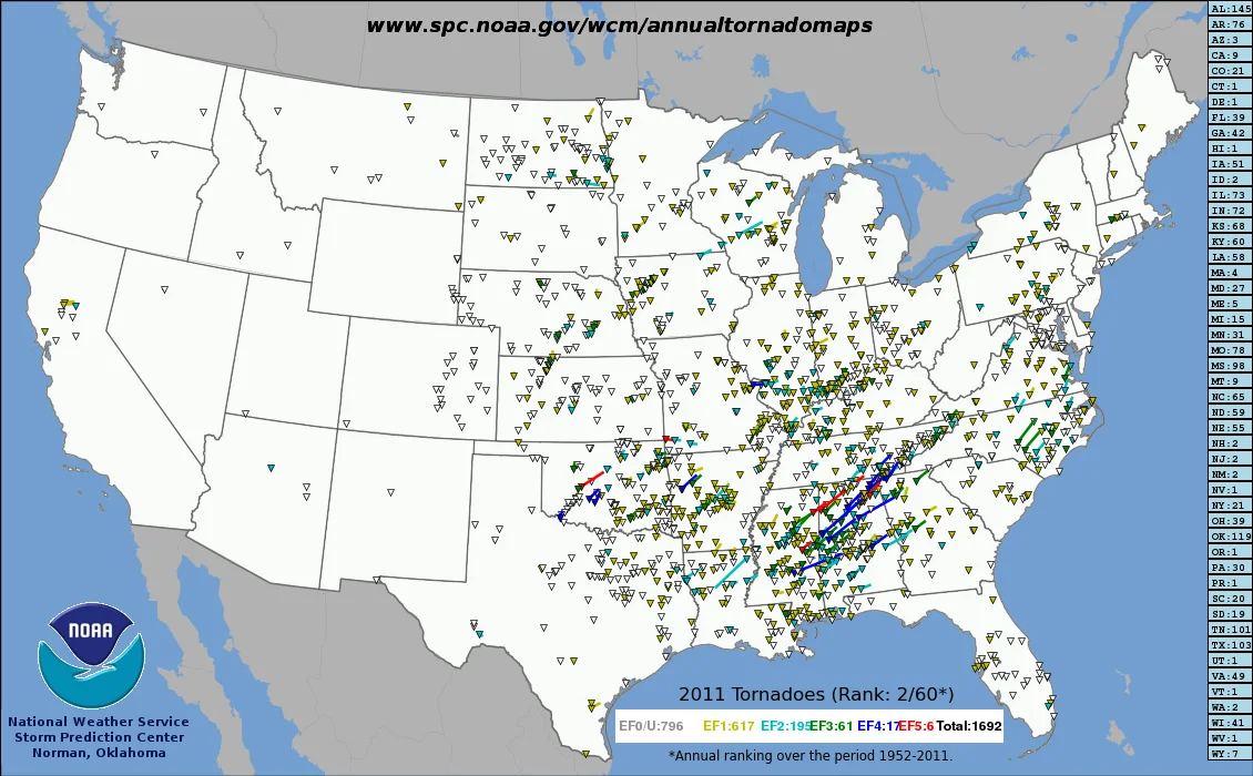
Tornado tracks as reported in 2011. Image courtesy NOAA.
Part of the upper hand the South has in terms of boosting its twister count is that tornado season there has not one, but two 'peak' periods; one in the late fall, and one in the late winter/early spring. It's no coincidence that both of these coincide with when the transitional period between winter and summer-like jet streams takes place over the continent (we talked about this above). In November, we start to see the Bermuda High - a semi-permanent area of high pressure off the Atlantic coast - recede east across the ocean, allowing jet stream troughs to 'dig' more deeply into the Southeast, bringing that cold, dry air out of the Plains to collide with lingering moist, humid air in the Gulf States. The same happens in reverse in late-winter, when the pattern starts to swing back the other way.
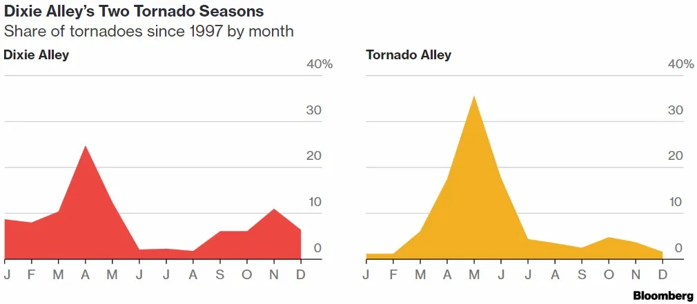
Two 'peak' seasons in the South. Image courtesy Bloomberg.
This doesn't mean states like Texas, Oklahoma or Kansas won't get tornadoes; they are still on the top of the list when it comes to tornado frequency. But the trend in many locations is down over the past 40 years. Dr. Vittorio Gensini from Northern Illinois University and Dr. Harold Brooks from the National severe Storms Laboratory in Norman, Oklahoma have tracked the number of tornado reports between 1979 and 2017 to find that over the past four decades tornado activity has decreased in parts of Texas, Oklahoma, Colorado, Nebraska and Kansas. A period during which the frequency of tornados increased considerably across a large swath of the Midwest and Southeast U.S.
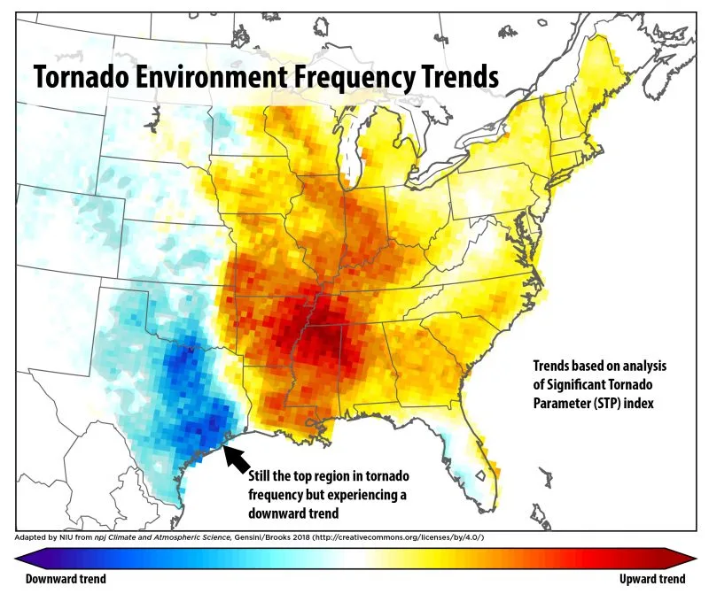
Image courtesy University of Illinois/Gensini/Brooks
This thorough investigation also looked into the regional trends in the daily frequency of tornado-environment formation over the same time period (1979 to 2017) by using an index known as the Significant Tornado Parameter (STP). This index is frequently applied in severe weather prediction in order to capture the coexistence of atmospheric ingredients favorable for tornadogenesis.
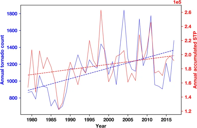
Interannual variability of United States tornado reports (blue; axis left) and the United States annual sum of daily max significant tornado parameter (red; axis right), Image courtesy NARR
OCEAN IMPACT ON TORNADOES
Tornadoes depend on severe thunderstorm development, and during El Niño, a shift of the jet stream farther south blocks moisture from the Gulf of Mexico, reducing the fuel for these large thunderstorms. On the other hand, La Niña brings a more wavy and northward shifted jet stream, which might be expected to enhance severe weather activity in the south and southeast. Indeed, historic tornado outbreaks in 1974, 2008 and 2011 started during La Niña conditions.
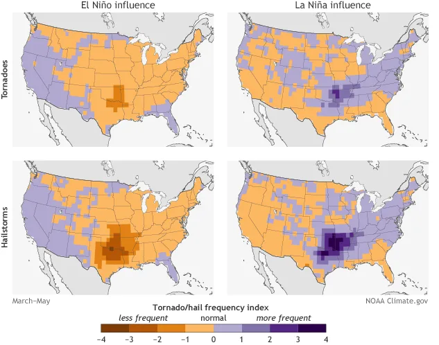
Image courtesy NOAA/Climate.gov
A research group from the University of Miami turned their focus on the Gulf of Mexico as a warning sign for severe weather season, comparing the difference between weather in a 'cold' Gulf season and a 'warm' one. As was mentioned above, the Gulf of Mexico is one of the major heat and moisture drivers for severe weather and tornadoes in the United States, so it stands to reason that the general 'feeling' of the Gulf would impact what we see on land.
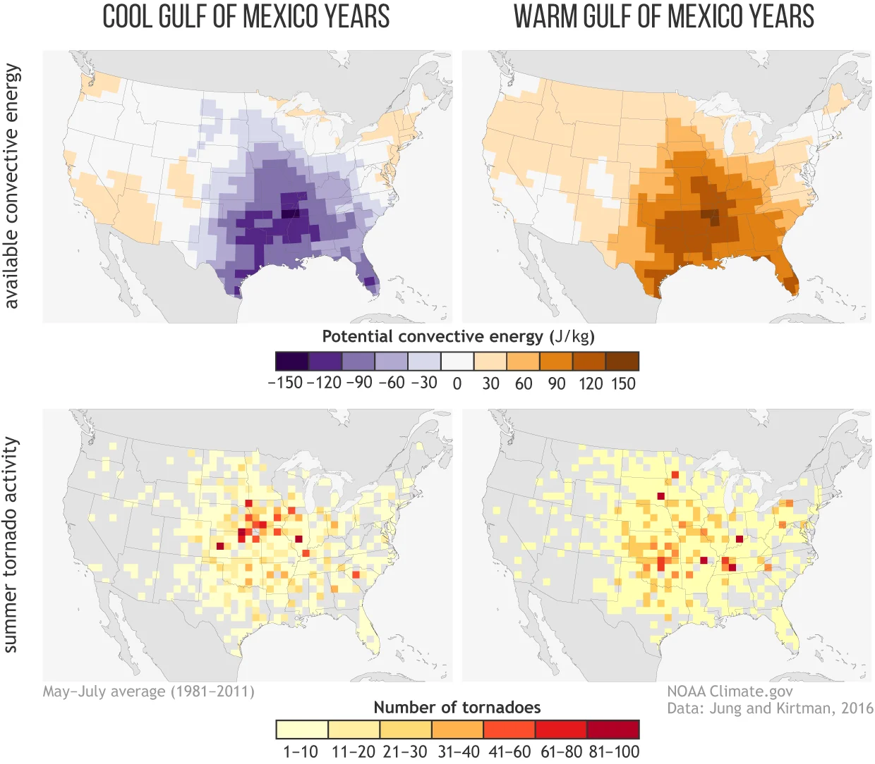
Image courtesy NOAA/Climate.gov
After looking at 30 years of data, the team found a possible link between sea surface temperatures (SST) in the Gulf and seasonal prediction of severe weather trends in the country. Perhaps not surprisingly, the average amount of atmospheric energy - the CAPE - seems to be linked to the water temperature in the Gulf; in years with warmer Gulf waters, we see more energy, and thus more favorable conditions for severe storms to develop. In years with cooler SST, we see diminished activity. While we can't use that to predict individual storms, it might work as an early-warning system to indicate whether we expect an active tornado season or a quiet one. While predicting specific weather systems is limited to about a week's lead time, models are pretty good at forecasting SST in the Gulf of Mexico about three months out.
CLIMATE CHANGE? OR SOMETHING ELSE?
While there is a growing body of research into what severe weather scientists expect to see with a changing climate over the United States, there are still a lot more questions than answers.
At this point, it is unclear whether the observed trends in tornado environment and reported frequency are due to natural variability or altered by anthropogenic forcing of the climate system. Global and regional climate model studies indicate a general increase in severe weather frequency (especially in boreal spring). They also point towards an increase in variability by the end of the 21st century in portions of the Midwest and Southeast, suggesting that the trends herein may indeed be due to anthropogenic forcing given the accumulating literature examining tornado and severe weather frequency and variability.
As one research team concluded, at this point studies into what climate change will mean for the intensity, number, and distribution of tornadoes largely serve to highlight the need for more studies. While it may be frustrating that we can't make a conclusive link between any one outbreak - or even any one season - between our day-to-day weather and a shifting climate, the picture isn't completely unclear.
“Can you link any particular season to climate change? The answer is no,” Dr. Victor Gensini from the University of Northern Illinois said in an interview. “But climate change is sort of what we say 'loading the dice' for these events to happen.”
Sources: | National Centers for Environmental Information | Purdue University | Bloomberg | Climate.gov | Current Climate Change Reports Journal | Nature |