
Shifting lake-effect pattern extends into western end of GTA, more extreme cold

Another round of lake-effect snow will impact parts of southern Ontario Tuesday, with afternoon commute times threatened as an extensive band extends into the western edge of the GTA.
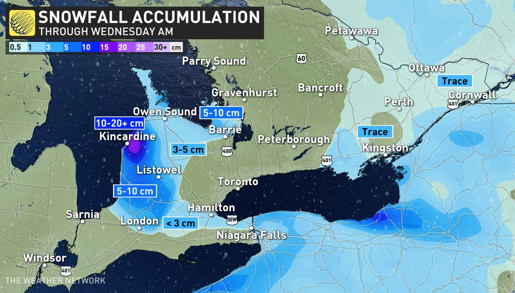
Some drivers will face another day of difficult travel across parts of southern Ontario, as bands of heavier lake-effect snow will continue off of Lake Huron and Georgian Bay. That's as snow banks remain high from last week's epic early week blizzard, and a fresh round of snow that brought additional accumulations just yesterday. Though most of Tuesday's squalls will impact the traditional snowbelt regions, some will also stretch as far as the western extents of the Greater Toronto Area at times. Afternoon and evening commute times may be jeopardized once again. While the majority of the snow squalls will ease through pre-dawn Wednesday, temperatures are set to plunge Tuesday night, with the frigid conditions locking in for the week. Extreme cold warnings are widespread across the south, including for the city of Toronto. More on the snow squall timing and impacts, as well as a look ahead to the colder temperatures, below.
DON’T MISS: Here's how to stock your vehicle's emergency kit, BEFORE you get stranded
TUESDAY: LAKE-EFFECT SNOW SQUALLS CONTINUE TO HAMPER TRAVEL
Combined with a clipper, southwesterly winds over Lake Ontario enhanced snowfall rates in the eastern GTA Monday, especially for areas closer to the lakeshore. It made for tricky and dangerous travel, with as much as 20 cm forecast for the hardest hit places.
Snow squalls are forecast to impact communities southeast of Lake Huron and Georgian Bay through the day on Tuesday, with some squalls even stretching as far as the western extents of the GTA at times. Snow squall warnings and winter weather travel advisories have been issued for parts of the region.
SEE ALSO: Did a water main break near your home? Here's what happens next
With blustery northwest winds of 30-50 km/h expected through much of the day, the snow squalls are forecast to extend into parts of the GTA, just in time for the afternoon and evening commute once again.
"The snow squall off Lake Huron is forecast to extend into Kitchener-Waterloo, the western side of the Golden Horseshoe including Hamilton, and stretch across parts of the QEW as far as St. Catharines and Niagara Falls into the evening," says Kelly Sonnenburg, a meteorologist at The Weather Network. "This will bring bursts of snow and reduced visibility. "
The majority of the snow squalls in southern Ontario will ease through pre-dawn Wednesday.
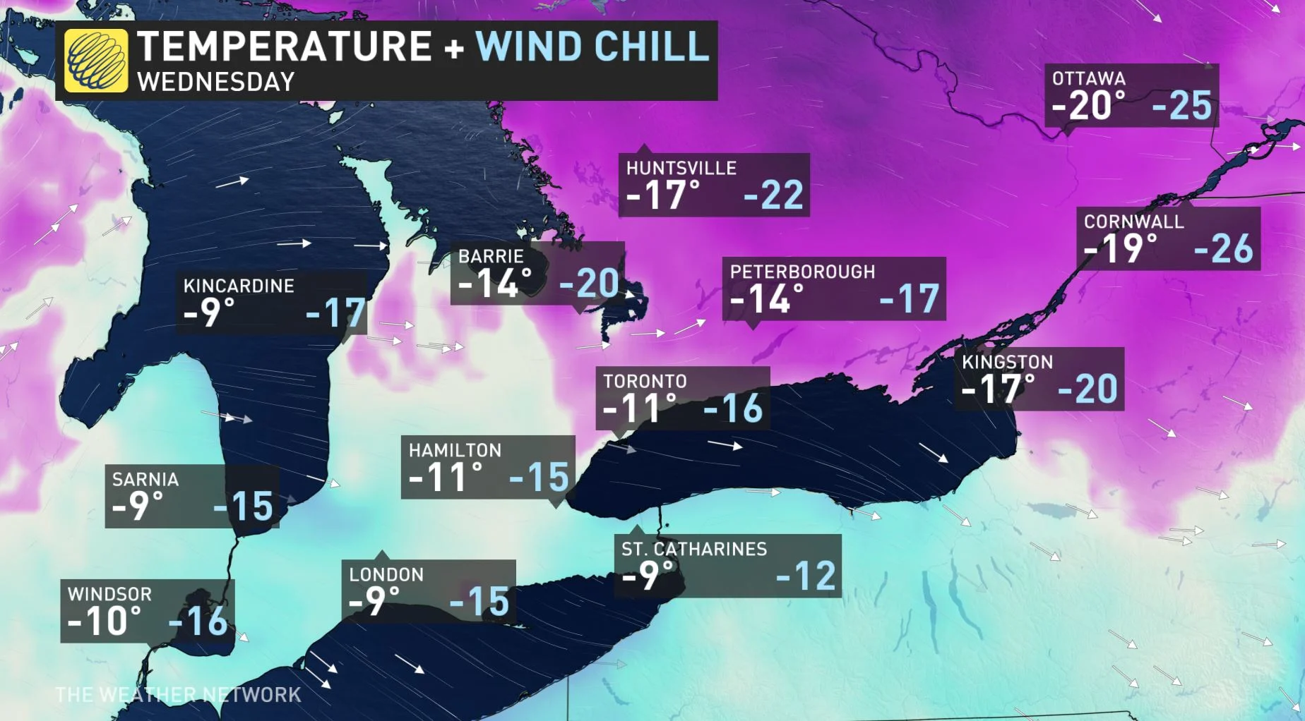
WEDNESDAY AND BEYOND: TEMPERATURES PLUNGE WITH ANOTHER BLAST OF ARCTIC AIR
As the squalls ease, Ontario is facing a persistently cold pattern through much of this week. A shot of reinforced cold air will make a return to southern Ontario Tuesday night into early Wednesday morning. Extreme cold warnings span much of the south.
Temperatures are expected to dip into the -20s Tuesday night, plunging below -30 towards cottage country. Wednesday, the coldest day of the week, will see daytime high temperatures struggling to reach the -20s for Ottawa and staying below the -10-degree mark for the GTA.
"Extreme cold puts everyone at risk," says Environment and Climate Change Canada in the warning. "Risks are greater for young children, older adults, people with chronic illnesses, people working or exercising outdoors, and those without proper shelter. Dress warmly. Dress in layers that you can remove if you get too warm. The outer layer should be wind resistant."
Frostbite can develop within minutes on exposed skin, especially with wind chill.
Thursday will see see temperatures moderate somewhat, however, a gusty southwest wind will keep it from feeling milder due to the wind chill. Another shot of Arctic air will send temperatures back well below seasonal Friday and on the weekend.
LOOK AHEAD TO FEBRUARY AND THE BATTLE FOR MILDER AIR
A bigger pattern change is expected for the start of February, as the frigid weather will shift back to Western Canada and remain there for the month. While the pattern will definitely be milder than what we are seeing for the second half of January, it is possible that early February will also include some high-impact and messy storms.
"The question is whether the warmer weather can take over and give us an extended thaw or whether the Arctic air to the west will fight back and attempt to push back into the region at times — resulting in a changeable and stormy pattern," says Dr. Doug Gillham, another meteorologist at The Weather Network.
Subscribe to 'This Day in Weather History': Apple Podcasts | Amazon Alexa | Google Assistant | Spotify | Google Podcasts | iHeartRadio | Overcast'
Check back for the latest forecast across Ontario.