Friday, June 24th 2022, 10:05 pm - Slow-moving severe thunderstorms and heavy rain will continue to roll across the eastern Prairies overnight Friday into Saturday.
Thunderstorms and widespread heavy rainfall will continue rolling through portions of Manitoba and northwestern Ontario overnight Friday into Saturday morning as a system slowly makes its way across the Prairies. Folks in the path of the storms can expect intense rainfall, strong wind gusts, and large hail. More on what to expect tonight and through next week, below.
TORNADO 101: What you need to know about staying safe
FRIDAY NIGHT: SEVERE STORMS RUMBLE THROUGH MANITOBA AND NORTHWEST ONTARIO
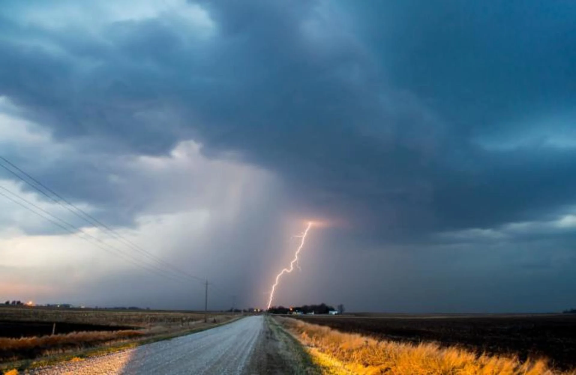
Yet another round of severe thunderstorms targeted the eastern Prairies during the day on Friday. A slow-moving squall line developed south of the border and gradually filled into southern Manitoba and northwestern Ontario through Friday evening.
Folks in the path of the strongest storms can expect intense rainfall rates at the very least, with strong wind gusts and large hail possible in some of the storms. Keep an eye on warnings through the evening and make sure you’re prepared to take quick action if your location is under threat.
These slow-moving storms will continue through Friday night and into the wee hours on Saturday.
WATCH BELOW: TORNADO SAFETY TIPS
LOOKING AHEAD: TEMPERATURES RISE AND FALL WITH RAIN CHANCES
The weekend will start off on a wet note across Manitoba as widespread rain spreads over the province for the day on Saturday. Scattered showers are possible farther west in Saskatchewan.
A risk for thunderstorms will build across the western Prairies as a boundary parks itself over the region.
Some of the thunderstorms could approach severe limits from northeastern British Columbia through central Saskatchewan, including Fort McMurray, Prince Albert, and Saskatoon.
The strongest storms that form in these areas could produce strong wind gusts, large hail, and heavy rainfall.
READ MORE: Here’s what to stock your vehicle emergency kit with, BEFORE you hit the road
Sunday will see a cold front sagging south from the northern Prairies. Conditions will briefly warm up ahead of the front, with temperatures falling to near- or below-seasonal levels for much of the week.
Here's a look at some of the storms that have swept across the Prairies this week:
Thank you @KarenTookTK for providing the evidence of the giant hail that fell in #Binscarth, Manitoba! Today once again there is a risk of damaging storms beginning in southern MB this aft & shifting east into NW Ontario tonight. Stay weather aware! @weathernetwork pic.twitter.com/LLOLSxTfHy
Thank you Chris Murphy TWN on Twitter: "Thank you @KarenTookTK for providing the evidence of the giant hail that fell in #Binscarth, Manitoba! Today once again there is a risk of damaging storms beginning in southern MB this aft & shifting east into NW Ontario tonight. Stay weather aware! @weathernetwork pic.twitter.com/LLOLSxTfHy / Twitter" for providing the evidence of the giant hail that fell in Chris Murphy TWN on Twitter: "Thank you @KarenTookTK for providing the evidence of the giant hail that fell in #Binscarth, Manitoba! Today once again there is a risk of damaging storms beginning in southern MB this aft & shifting east into NW Ontario tonight. Stay weather aware! @weathernetwork pic.twitter.com/LLOLSxTfHy / Twitter", Manitoba! Today once again there is a risk of damaging storms beginning in southern MB this aft & shifting east into NW Ontario tonight. Stay weather aware! Chris Murphy TWN on Twitter: "Thank you @KarenTookTK for providing the evidence of the giant hail that fell in #Binscarth, Manitoba! Today once again there is a risk of damaging storms beginning in southern MB this aft & shifting east into NW Ontario tonight. Stay weather aware! @weathernetwork pic.twitter.com/LLOLSxTfHy / Twitter" Chris Murphy TWN on Twitter: "Thank you @KarenTookTK for providing the evidence of the giant hail that fell in #Binscarth, Manitoba! Today once again there is a risk of damaging storms beginning in southern MB this aft & shifting east into NW Ontario tonight. Stay weather aware! @weathernetwork pic.twitter.com/LLOLSxTfHy / Twitter"
— Chris Murphy TWN (@MurphTWN) Chris Murphy TWN on Twitter: "Thank you @KarenTookTK for providing the evidence of the giant hail that fell in #Binscarth, Manitoba! Today once again there is a risk of damaging storms beginning in southern MB this aft & shifting east into NW Ontario tonight. Stay weather aware! @weathernetwork pic.twitter.com/LLOLSxTfHy / Twitter"
Supercell NW of Foxwarren, Manitoba has quickly become HP #mbstorm 9:30PM @PrairieChasers pic.twitter.com/nJtPa5ouvG
Supercell NW of Foxwarren, Manitoba has quickly become HP Braydon Morisseau on Twitter: "Supercell NW of Foxwarren, Manitoba has quickly become HP #mbstorm 9:30PM @PrairieChasers pic.twitter.com/nJtPa5ouvG / Twitter" 9:30PM Braydon Morisseau on Twitter: "Supercell NW of Foxwarren, Manitoba has quickly become HP #mbstorm 9:30PM @PrairieChasers pic.twitter.com/nJtPa5ouvG / Twitter" Braydon Morisseau on Twitter: "Supercell NW of Foxwarren, Manitoba has quickly become HP #mbstorm 9:30PM @PrairieChasers pic.twitter.com/nJtPa5ouvG / Twitter"
— Braydon Morisseau (@BraydonMoreSo) Braydon Morisseau on Twitter: "Supercell NW of Foxwarren, Manitoba has quickly become HP #mbstorm 9:30PM @PrairieChasers pic.twitter.com/nJtPa5ouvG / Twitter"
Intense lightning SW of Oyen this afternoon! #abstorm @weathernetwork pic.twitter.com/heeBxF1c3d
Intense lightning SW of Oyen this afternoon! Kyle Brittain on Twitter: "Intense lightning SW of Oyen this afternoon! #abstorm @weathernetwork pic.twitter.com/heeBxF1c3d / Twitter" Kyle Brittain on Twitter: "Intense lightning SW of Oyen this afternoon! #abstorm @weathernetwork pic.twitter.com/heeBxF1c3d / Twitter" Kyle Brittain on Twitter: "Intense lightning SW of Oyen this afternoon! #abstorm @weathernetwork pic.twitter.com/heeBxF1c3d / Twitter"
— Kyle Brittain (@KyleTWN) Kyle Brittain on Twitter: "Intense lightning SW of Oyen this afternoon! #abstorm @weathernetwork pic.twitter.com/heeBxF1c3d / Twitter"
UNREAL #SKstorm pic.twitter.com/iNZ4RvQYVE
UNREAL Andrew Guidarelli 🌪 on Twitter: "UNREAL #SKstorm pic.twitter.com/iNZ4RvQYVE / Twitter" Andrew Guidarelli 🌪 on Twitter: "UNREAL #SKstorm pic.twitter.com/iNZ4RvQYVE / Twitter"
— Andrew Guidarelli 🌪 (@a_guidarelli) Andrew Guidarelli 🌪 on Twitter: "UNREAL #SKstorm pic.twitter.com/iNZ4RvQYVE / Twitter"
Oh my not good #skstorm possible wedge tornado 636pm trying to get better look can't confirm pic.twitter.com/bfxP8vUanT
Oh my not good Craig Boehm on Twitter: "Oh my not good #skstorm possible wedge tornado 636pm trying to get better look can't confirm pic.twitter.com/bfxP8vUanT / Twitter" possible wedge tornado 636pm trying to get better look can’t confirm Craig Boehm on Twitter: "Oh my not good #skstorm possible wedge tornado 636pm trying to get better look can't confirm pic.twitter.com/bfxP8vUanT / Twitter"
— Craig Boehm (@Skstormchaser) Craig Boehm on Twitter: "Oh my not good #skstorm possible wedge tornado 636pm trying to get better look can't confirm pic.twitter.com/bfxP8vUanT / Twitter"
Storm west of Morrin! #abstorm 330PM pic.twitter.com/7po0esd2u5
Storm west of Morrin! Kyle Brittain on Twitter: "Storm west of Morrin! #abstorm 330PM pic.twitter.com/7po0esd2u5 / Twitter" 330PM Kyle Brittain on Twitter: "Storm west of Morrin! #abstorm 330PM pic.twitter.com/7po0esd2u5 / Twitter"
— Kyle Brittain (@KyleTWN) Kyle Brittain on Twitter: "Storm west of Morrin! #abstorm 330PM pic.twitter.com/7po0esd2u5 / Twitter"
Thumbnail courtesy of Unsplash.
Be sure to check back for the latest updates across the Prairies.