Science Behind the Weather: What is a derecho?

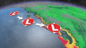
Derechos are so powerful they can rival the strength of a hurricane
The word invokes just as much trepidation as "hurricane" or "tornado" to those who know the power of a derecho, but what's behind this uncommon form of severe weather?
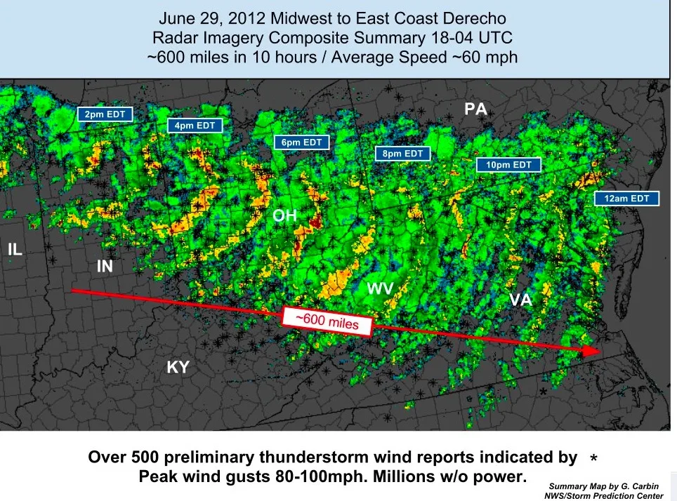
A derecho is defined as a violent, prolonged wind event, produced along the leading edge of a widespread storm system known as a 'mesoscale convective system', or MCS. It forms a curved (or bowed) line of thunderstorms, frequently called a 'bow echo' due to its shape on radar. A derecho can generate hurricane-force winds, spawn tornadoes and even cause flash flooding due to the heavy rainfall associated with them.
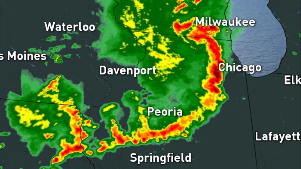
A composite radar image showing the June 29-30, 2012 derecho that impacted much of the eastern United States. Winds from the storm toppled and uprooted trees, damaged buildings, and caused widespread power failures in the middle of an extreme heatwave. Credit: NOAA/NWS
What's behind these violent weather outbreaks?
The mechanisms that come into play to produce a derecho are relatively common, regularly seen with other types of storms. In this case, however, the intensity is ramped up into the extreme.
When a large thunderstorm or line of thunderstorms develops, currents of air known as updrafts blow upwards inside the cloud. Driven by the heat released by the condensing of water vapour from the rising humid air, this grows the cloud and produces rain droplets. As the storm matures, precipitation and cooled air from the top of the cloud fall towards the ground, forming a rain-laden downdraft. This is the normal progression of thunderstorm development.
Sometimes, the raindrops in the downdraft encounter dry air just beneath the base of the stormcloud. If you have ever seen virga, where rain falls from a cloud, but it does not reach the ground, this is an example of having dry air beneath a thunderstorm. In this case, the falling raindrops quickly evaporate into that dry air, causing the air to cool. The drier the air was before the rain started to fall into it, the cooler that pocket of air becomes.
Now, as a general rule, cooler air is denser than warmer air. So, as that air pocket just beneath the cloud cools, it also becomes denser than the warmer beneath it. As a result, it sinks towards the ground, and the warmer air underneath rises to take its place. This injection of warmer air into the cloud's base causes a strengthening of the storm. Meanwhile, when that sinking cool air reaches the ground, it expands outward from under the storm, producing a gust front.
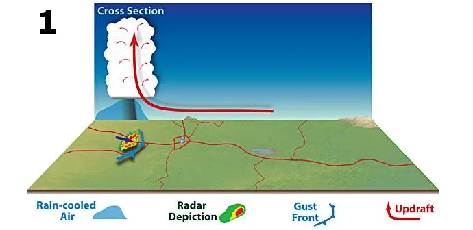
The formation of a storm and gust front. Credit: NOAA Storm Prediction Center
As shown in the diagram above, this gust front acts just like a mini Cold Front. The winds plow forward like a steep wedge, driving the warmer air in their path to quickly rise. This produces even more thunderstorm activity along the gust front.
The setup is now complete, but a derecho takes this whole scenario to an extreme!
In the beginning stages of a derecho, the rain falling from the base of the cloud encounters extremely dry air. This air cools so rapidly due to rainfall evaporation that it plummets towards the ground. This produces not only a gust front, but it also generates a small area of low pressure in its wake. This low pressure pulls in a flow of air from behind the storm, which meteorologists call a rear-inflow jet.
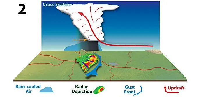
The storm with an expanded cool pocket of air beneath, forming a stronger gust front, and drawing in the rear-inflow jet to increase its forward motion. Credit: NOAA Storm Prediction Center
As shown in the diagram above, the jet causes the base of the updraft to suddenly surge forward, tilting the entire updraft towards the rear of the storm. This increases the total area affected by the storm, including the size of the dry air pocket beneath it. This ultimately causes the entire process to strengthen, in a positive feedback loop.
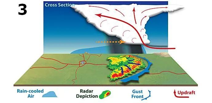
The bow echo is now widespread, producing powerful thunderstorms along the leading edge of the storm system. Credit: NOAA Storm Prediction Center
NOT ALL GUST FRONTS
Many storms can produce gust fronts, but specific criteria are needed for one to qualify as a derecho.
If a bow echo reaches at least 250 miles wide and produces persistent winds of at least 58 mph, then it can be called a derecho (pronounced as dare-AY-cho).
Watch below: Trees snap as derecho hits U.S. Midwest
DANGEROUS, BUT ALSO STRIKINGLY BEAUTIFUL
One striking visual aspect of a derecho is the immense shelf clouds that this weather pattern can produce.
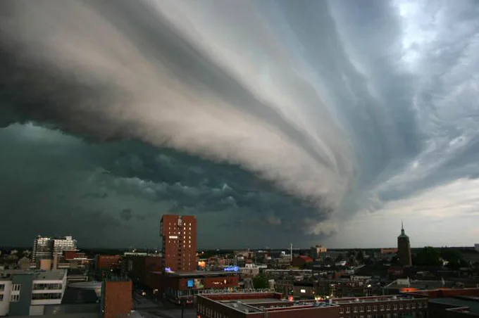
This amazing shelf cloud passed over Enschede, the Netherlands on July 17, 2004. Credit: John Kerstholt/Wikimedia Commons
WHY ARE DERECHOS SUCH A CONCERN?
There's a reason why a common nickname for a derecho is an 'inland hurricane'. The winds produced by these events can be just as powerful and damaging as those experienced during a tropical storm or hurricane. The vigorous storms produced along the derecho squall line can even spawn tornadoes, adding to any straight-line wind damages.
Additionally, the swift movement of these storms, along with the 'wedging' effect the system has on any warm, moist air just in front of the gust front, can produce thunderstorms with extremely heavy rainfall amounts that can touch off flash flooding.
Sources: WeatherPredition.com | NOAA Storm Prediction Center