Quebec: Heavy snow continues to blanket southern areas of the province

Parts of Quebec could see 10-20 cm of snow through Tuesday morning
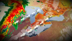
The same system tha brought hours of freezing rain to large parts of Ontario is continuing to bring heavy snow to southern Quebec and will do so through Tuesday morning.
Snowfall warnings and special weather statements remain in place for many, as snowfall totals will hit 10-20 cm through Tuesday.
We take a look at the current blast of snow and how long it will last, below.
WEATHER HIGHLIGHTS:
Heavy snow continues for warned areas through Tuesday morning
Temperatures climb behind system
Stay up-to-date on the ALERTS in your area
SNOW CONTINUES THROUGH TUESDAY MORNING
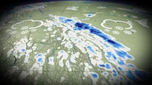
Heavy snow will blanket southern Quebec through Tuesday morning. The highest accumulations will fall in the southern Laurentians, Montreal, Eastern Townships and much of the St. Lawrence Valley, where 10-20 cm is expected. Central and northern areas will see 5-10 cm of snow.

BRIEF WARMUP TO START THE NEW YEAR
A week westerly flow will set up behind the system and continue into the new year, keeping temperatures above seasonal through the first weekend of 2020. However, arctic air will sink south over Hudson Bay to start next week, causing temperatures to dip well below seasonal.
Stay tuned to The Weather Network for the latest forecast updates.